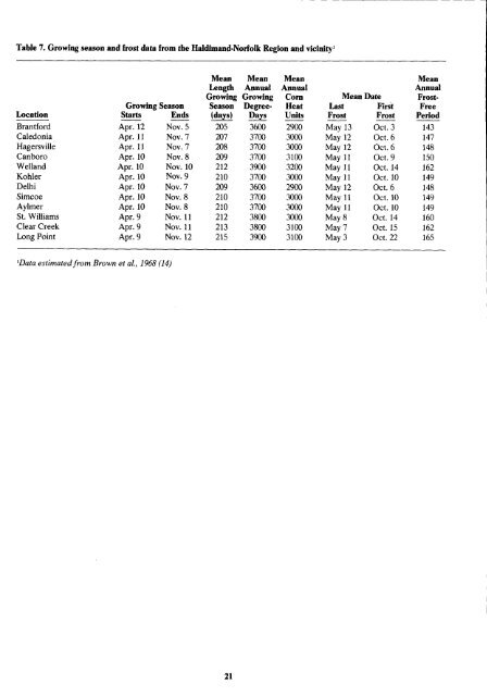
Table 7 . Growing season and frost data from the Haldimand-Norfolk Region and vicinity' 'Data estimatedfrom Brown <strong>et</strong> aL, 1968 (14) Mean Length Growing Mean Annual Growing Mean Annual Corn Mean Date Mean Annual Frost- Growing Season Season Degree- Heat Last First Free Location Starts Ends (days) Days Units Frost Frost Period Brantford Apr . 12 Nov . 5 205 3600 2900 May 13 Oct . 3 143 Caledonia Apr . 11 Nov . 7 207 3700 3000 May 12 Oct . 6 147 Hagersville Apr . 11 Nov . 7 208 3700 3000 May 12 Oct . 6 148 Canboro Apr . 10 Nov . 8 209 3700 3100 May 11 Oct . 9 150 W<strong>et</strong>land Apr . 10 Nov . 10 212 3900 3200 May 11 Oct. 14 162 Kohler Apr . 10 Nov. 9 210 3700 3000 May 11 Oct . 10 149 Delhi Apr . 10 Nov . 7 209 3600 2900 May 12 Oct . 6 148 Simcoe Apr . 10 Nov. 8 210 3700 3000 May 11 Oct . 10 149 Aylmer Apr. 10 Nov . 8 210 3700 3000 May 11 Oct. 10 149 St. Williams Apr. 9 Nov. 11 212 3800 3000 May 8 Oct . 14 160 Clear Creek Apr. 9 Nov. 11 213 3800 3100 May 7 Oct. 15 162 Long Point Apr . 9 Nov. 12 215 3900 3100 May 3 Oct . 22 165
Table 8. First field seeding or planting dates for commercial production of veg<strong>et</strong>ables in the Haldimand-Norfolk region' Crops First Planting Dates FROST-HARDY asparagus, broccoli, brussel April 15 - April 25 sprouts, cabbage, l<strong>et</strong>tuce, onion, radish, rhubarb, pea, spinach, parsnip, early potato SEMI-FROST-HARDY be<strong>et</strong>, carrot, cauliflower, celery, late potato, early swe<strong>et</strong> corn SEMI-FROST-TENDER snap bean, swe<strong>et</strong> corn, tomato May 15 - May 25 FROST-TENDER April 25 - May 10 lima bean, cucumber, May 25 - June 5 eggplant, muskmelon, pepper, pumpkin, squash, watermelon 'Adapted from OMAF Publication 363, 1983 Veg<strong>et</strong>able Production Recommendations Forest Veg<strong>et</strong>ation Although s<strong>et</strong>tlers began clearing forests in the Haldimand- Norfolk Region in the late 1700's, 75% of the land was still forested by 1850 (16) . During the next 50 years much of the remaining forest cover was removed ; by 1900 only about 20% was still standing . In 1981 woodland occupied 9% of the region .' During this long forest-clearing period, lumbering was the chief industry in the region until the late 1800's, when agriculture became dominant . Many of the logs were floated down Big Creek and the Grand River to lakeside ports from whence they were shipped . Soon after the sand plains were cleared, depl<strong>et</strong>ed fertility and wind erosion forced the abandonment of many farms . Some fairly extensive areas of these degraded sands were reforested in the early 1900's to mainly exotic and nonindigenous conifer species, such as Scots pine, red pine and jack pine (16) . Many windbreaks of these species were planted in remaining sections of the sand plains, during the 1920's and 1930's, as tobacco became the most important agricultural crop . 'Data compiledfrom Census of <strong>Canada</strong>, 1981 . Figure 18 . Aerial view of tobacco farm, showing windbreaks and reforestation to reduce wind erosion Notes and maps from the original surveys compl<strong>et</strong>ed prior to s<strong>et</strong>tlement in the region indicate an extremely diverse original forest due, in part, to variable soil and moisture conditions, but also due to fires s<strong>et</strong> by Indians prior to white s<strong>et</strong>tlement (16) . Among the dominant forest associations recorded were hard maple - beech - elm - basswood on many of the upland clay and silt areas ; almost as widespread on similar upland areas was a butternut - chestnut - white ash - black cherry association . The sand plains were dominated by white pine associations, and oak savannas . Moist lowland areas were often dominated by a single species such as white cedar, willow, alder, tamarack, soft maple or black ash (16) . The Haldimand-Norfolk Region is entirely within the Carolinian zone, a climatic zone that supports native plants and animals having affinities with more southerly areas . Trees of the Carolinian zone that occur in the region include black walnut, shagbark hickory, swe<strong>et</strong> chestnut, black oak . tulip tree, sassafras and sycamore . Although the original surveys noted some stands dominated by walnut near the mouth of the Grand River, it was estimated that only about 1 %, of the original forest consisted of such Carolinian species, about the same proportion as in present-day stands (16) . In 1963 Maycock (17) estimated that there were fewer than 25 forest stands of 10 ac or more in the Region that were not being logged severely or grazed . One of the bestconserved stands is the Backus Woods in the Port Rowan - Turkey Point area . It occurs on predominantly moist silty clays and sands, and contains many Carolinian elements. Other unique stands occur on the eolian sands and dunes of Turkey Point Provincial Park, and on Long Point Peninsula . The dune ridges of Long Point contain several interesting savanna and forest communities, dominated by such species as eastern cottonwood, red cedar, red oak, white pine, red maple and red ash (18) . The 1981 Census of <strong>Canada</strong> indicated that woodland comprised about 9% of the total area of the region . Plantation forests of red pine, white pine, jack pine, Scots pine, Norway spruce and white spruce occupy a significant portion of woodlands on well-drained sands . Elsewhere, the present forest associations are generally similar to those indicated in Figures 19, 20 and 21 .