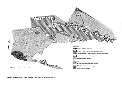
Port Dover Figure 9. Bedrock geology of the Regional Municipality of Haldimand-Norfolk DEVONIAN Marcellus Formation - gray shale Dundee Formation - weakly cherty fossiliferous limestone Onondaga Formation (D<strong>et</strong>roit River Group) - limestone and dolostone Bois Blanc Formation - cherry limestone Oriskany Formation - sandstone SILURIAN WAWAN iiAN Bertie and Bass Islands Formations - dolostone Salina Formation - shale, dolostone, gypsum Guelph Formation - dolostone
mainly bedrock-controlled. Most of the streams, such as the Nanticoke, Sandusk and Stoney, reflect the low gradient of the limestone bedrock (5) . There is some dissected moderately well-drained land close to these streams, but most of the land is imperfectly or poorly drained . Bedrock Geology The bedrock of the Regional Municipality of Haldimand- Norfolk is shown in Figure 9 . It is composed of sedimentary Paleozoic rocks of Silurian and Devonian ages . These rocks occur in flat-lying beds that slope gently in a southerly direction . The main bedrock relief is provided by the Onondaga escarpment, formed by resistant dolostones and limestones over softer shales . Its maximum height is 15 m, but it is usally more subdued and often masked by surficial sediments. The oldest bedrock in the region is the Guelph formation north of Caledonia, which consists of gray to buff, sugary dolostone . Most of the oil and natural gas, that have been drilled for so extensively in the Region, has come from Silurian sandstones and dolostones that underlie the Guelph formation (7) . The Salina formation, which forms the caprock b<strong>et</strong>ween the Guelph formation and the Onondaga escarpment, has a greater thickness of surficial deposits than the adjacent dolostones, because of its greater erodibility . It consists of alternating layers of gray shale and dolostone with lenses of anhydrite and gypsum . Outcrops are very scarce ; there are a few along the Grand River . The Salina formation has had a strong influence on the course of the Grand River and also, apparently, on the location of the drumlin field north of Hagersville . Gypsum is mined from the Salina formation near Hagersville and Caledonia (8) . The Bertie formation is composed mainly of resistant dolostones, which have produced the Onondaga escarpment (7) . These rocks outcrop at the surface in many places on, and adjacent to, the escarpment . They are a major regional source of crushed stone from quarries that extend from Dunnville to Hagersville (7) . The Oriskany formation underlies only one small area near Clanbrasil, east of Hagersville. It consists of quartz sandstone that outcrops at the surface or has only a thin soil cover . A unique assemblage of fossils, flora and fauna are found at this site (9) . The sandstone has been used as a source of building stone, silica and glass sand (8), and is presently being quarried for crushed stone. The Bois Blanc formation extends in a narrow band south and west of the Onondaga escarpment. It consists of moderately to thinly bedded cherty limestone, often with a basal sandstone member (7) . Drift thickness is rarely more than 5rriover this limestone, and there are numerous surface outcrops. These rocks also are extensively quarried in the region . The D<strong>et</strong>roit River group, consisting of limestone and dolostone, only forms a small wedge of the bedrock of the region north of Delhi . The Onondaga formation underlies part of the region, southwest of the Onondaga escarpment . It consists mainly of variable cherty, fossiliferous limestone (7) . Most of this formation occurs near the surface, at depths of 3 to 10 m. Many outcrops are present along stream courses and the Lake Erie shoreline . This limestone has been used, to a limited extent, for building stone and crushed stone . The Dundee formation occupies most of the bedrock of the region b<strong>et</strong>ween the Onondaga formation and Lake Erie . It consists ofweakly cherty, fossiliferous limestone, containing minor shale (7) . There is wide variation in the depth from the ground surface to this formation . It ranges from only 3 m below the ground surface in the Selkirk-Cheapside area, to 115 m near Port Rowan . Numerous outcrops of Dundee limestone occur along stream courses east of Port Dover . There are also several sinkholes in the floodplains of streams flowing over Dundee limestone (5). The Dundee limestone is quarried near Port Dover and Nanticoke . The youngest bedrock in the region is the Marcellus formation . It underlies the southwest corner of the region along the Lake Erie shore, and consists predominantly of gray shale, with interbeds ofgray, crystalline, cherty limestone . It is 80 to 100 m below the ground surface, and no surface outcrops are known . Surficial Geology and its Relation to the <strong>Soil</strong>s of the Region The surficial geology of most of the Haldimand-Norfolk region has been described in d<strong>et</strong>ail by Cowan (10), Feenstra (12,4,11), and Barn<strong>et</strong>t (5, 13) . The major physiographic regions and features are shown in Figure 6. In Table 4, the surficial deposits are correlated with the soils that developed on them . For example, the Fox, Brady and Granby soils developed mainly in the coarser sands deposited in shallower waters of glacial lakes Warren and Whittlesey, and which blank<strong>et</strong> much of the western part of the region . The Wattford, Normandale and St . Williams soils developed in the finer, more wind-modified sands, that represent deeper-water deposits of the same glacial lakes . Virtually all of these lacustrine sands have been eroded and sorted by wind action that created eolian landforms and deposits ranging from a few centim<strong>et</strong>res thick, to spectacular longitudinal dunes several m<strong>et</strong>res thick . The Plainfield, Walsingham, and Waterin soils have been mapped where eolian fine sand and very fine sand is greater than 1 m thick over the lacustrine sands . A Plainfield dune phase has been mapped wherever larger sand dunes are apparent. The landscape relationship of the Plainfield soils to the lacustrine Fox and Brady soils is shown schematically in Figure 10. Two other soils of limited extent were mapped on glacial and post-glacial fluvial and lacustrine sediments. Lowbanks soils, the so-called "black sands" of the Dunnville area, are mapped on the poorly drained sands deposited by the ancestral Grand River, and Burford soils occur on the sand and gravel terraces of old river channels . Three major tills outcrop in the region ; the Port Stanley, Wentworth, and Halton tills . The oldest of these, the Port Stanley till, outcrops near the western boundary of the region and is expressed in the Tillsonburg, Courtland and Mabee moraines (Figure 6) . The Muriel, Gobles and Kelvin soils have developed on this brown, silty clay loam till . Where sand blank<strong>et</strong>s the till to a depth of 40 to 100 cm, till phases of the Bookton, Berrien and Wauseon soils are mapped . The relationship of these soils on the Tillsonburg moraine, to adjacent eolian and lacustrine sands, is shown in Figure 11 .