

Soil Report - Agriculture et Agroalimentaire Canada
Soil Report - Agriculture et Agroalimentaire Canada
Soil Report - Agriculture et Agroalimentaire Canada

You also want an ePaper? Increase the reach of your titles
YUMPU automatically turns print PDFs into web optimized ePapers that Google loves.
The Wentworth till occurs on two quite different landforms<br />
in the region . It outcrops on the drumlins centred b<strong>et</strong>ween<br />
Caledonia and Cayuga (Figure 6) . The Seneca soils developed<br />
on this drumlinized loam till are surrounded and often partly<br />
covered by glacial Lake Warren clays . This landscape<br />
relationship is shown schematically in Figure 12 . The other<br />
major location of the Wentworth till is in the moraines that<br />
extend from the north through Waterford, Simcoe and<br />
Delhi (Figure 6) . These extensions of the Galt and Paris<br />
moraines have been modified considerably by the action of<br />
waves and currents within glacial lakes . Consequently, the<br />
texture is mainly gravelly sandy loam, often overlain by sand<br />
deposits . Where sand deposits are absent to thin, the<br />
Wilsonville soils have been mapped, but wherever sand<br />
thickness ranges from 40 to 100 cm over till, the Scotland .<br />
Oakland and Vanessa soils are mapped . Gravel is being<br />
mined from these deposits, mostly in the Waterford and<br />
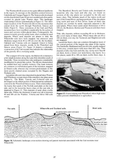
Simcoe areas (Figure 13) . Figure 14 depicts a schematic<br />
cross-section of the Galt moraine that indicates the relationship<br />
of the gravelly till to overlying sands .<br />
The youngest till in the region, the Halton till, is limited to<br />
a few small moraines along the Lake Erie shoreline south of<br />
Dunnville . These moraines have also undergone considerable<br />
modification by glacial lake action . The tills are characterized<br />
by reddish hues and variable textures . Clay loam textures<br />
are common on well-drained parts of the moraines, mapped<br />
as Ontario soils, whereas clay textures predominate on the<br />
more poorly drained areas occupied by the Niagara and<br />
Welland soils.<br />
Lacustrine silts and clays deposited in glacial lakes Warren<br />
and Whittlesey occupy most of the extensive clay plain areas<br />
(Figure 6) . The Brant, Tuscola and Colwood soils are<br />
developed on the siltiest portion of these lacustrine sediments,<br />
centred in the Waterford-Simcoe area . Their relationship to<br />
the loamy fine sands of the Norfolk sand plain on the west<br />
side, and to the lacustrine heavy clays on the east side, is<br />
depicted in Figure 15 . Thin deposits of sand often overlie<br />
these silts . Where the thickness of sand over silt is b<strong>et</strong>ween<br />
40 and 100 cm the Walsher, Vittoria and Silver Hill soils<br />
occur .<br />
Fox soils<br />
1<br />
% o<br />
77N_<br />
I o _aDO c3°,'"<br />
°<br />
. . . . . . °UQ<br />
ëop~oQ .40<br />
lacustrine loamy sand and sand<br />
: .:<br />
: : ::,c' : J~Op°<br />
:lacustrine . loamy ° : ; : : : '' .' . O° ° ° 0 QQdo° ° ` lot . . Q<br />
p od °<br />
o ° QQo4 d0o 00 " QO a° ~° ° o' O o ° Oo<br />
.sand and sand'' d0 .O Qo ô o~p °0400<br />
Wilsonville and Scotland soils<br />
The Brantford, Beverly and Toledo soils, developed on<br />
lacustrine silty clay loam and silty clay, are found on<br />
sections of the clay plains not occupied by the silts and<br />
heavy clays . That includes much of the region north and<br />
east of the Grand River, and large portions of the clay plains<br />
lying north and west of Port Dover . Some of these clay<br />
deposits are overlain by sands, especially adjacent to the<br />
sand plains . Where these sands attain thicknesses of 40 to<br />
100 cm, the Bookton, Berrien and Wauseon soils have been<br />
mapped .<br />
Thin, silty deposits, seldom exceeding 40 cm in thickness,<br />
also cover many of these clays . Where these silts are 40 to<br />
100 cm thick over clay the Tavistock and Maplewood soils<br />
are mapped .<br />
Lacustrine heavy clays are common throughout most of<br />
the central portion of the largest clay plain of the region .<br />
The Smithville, Haldimand and Lincoln soils, usually mapped<br />
in this area, contain layers with more than 60%, clay . Thin<br />
deposits of silty clay loam and silty clay, rarely more than 40<br />
cm thick, form a veneer over most heavy clay layers . In a<br />
few places, sands 40 to 100 cm thick overlie these clays . A<br />
Figure 13 . Gravel mining near Waterford, where high water<br />
tables prevent rehabilitation to agriculture<br />
"oa °~40° 0<br />
I Brant soils<br />
O o~<br />
o0°O°~<br />
Q o " p-~<br />
~ ~n<br />
o Q<br />
0 ~D<br />
o°DQ°0~ °U ° p A.Q~O° °~0<br />
~o ( QQ~QO o<br />
o ° .-~..~`Y++ï<br />
)<br />
o 0 ôo pd °Q aoQ ° _ ° o0e9ravelly sandy till , "0<br />
o<br />
°Q o 0 O o o ° Q o 0<br />
3~0D V~nQQ~ N °o~ op<br />
°ô~4ôaQ ôaQa<br />
° " ( ° :~doQ0L ô~~~~ô~~~<br />
°~~~~~<br />
Q°0a3 °<br />
'-O<br />
n_<br />
"<br />
pôpopp0°~Q QoQo~oOp~ô ~ôâooôô<br />
°o QOQo°°O~~°0o~0° Qo,Op<br />
dQ~ ~Ô e<br />
~~o~a<br />
Oo °<br />
c<br />
c<br />
°O ;<br />
0<br />
.O '° > , Q° D~aOü~~°°D~~~°O~~`aO°7~<br />
" oQQowv°V° ~-<br />
0<br />
Qp<br />
° Q°0 ~,0 ° ° °C<br />
Q% 0. °O oQQQaO" oo °O° °° OQO°°QQe . Ooo oO°Q 0<br />
0O' co<br />
OaQ~ ~~ "~ô oo~ o~QO oo~~ °OD. OQo~ O O~ o<br />
up<br />
OO ,<br />
Q .Ooo-o~°n °<br />
%~aQrnO°~~~aOro r~adô ,.°n(io/~o,-O_<br />
0.0 °~. ° . oéo-<br />
Figure 14 . Schematic landscape cross-section showing soil parent materials associated with the Galt moraine near<br />
Wilsonville<br />
(


