

Soil Report - Agriculture et Agroalimentaire Canada
Soil Report - Agriculture et Agroalimentaire Canada
Soil Report - Agriculture et Agroalimentaire Canada

You also want an ePaper? Increase the reach of your titles
YUMPU automatically turns print PDFs into web optimized ePapers that Google loves.
Lonsdale <strong>Soil</strong>s (LDL)<br />
Location and Extent Lonsdale soils are only mapped in a<br />
few locations in the Township of Delhi, northwest of<br />
Te<strong>et</strong>erville . There are 38 ha of pure Lonsdale map units, and<br />
81 ha of Lonsdale soils in complex map units where they are<br />
associated with Granby soils .<br />
Landform and Topography Lonsdale soils occupy depressional<br />
areas in the clav till moraines that cut across the<br />
northwest corner of the Township of Delhi . Topography is<br />
usually level .<br />
Parent Materials and Textures Lonsdale soils consist of 40-<br />
160 cm of organic soil over fine-textured soil materials,<br />
mainly clays. The surface organic soil is mainly highly<br />
decomposed humic material, and the underlying mineral<br />
soil is usually Port Stanley till with silty clay loam or silty clay<br />
textures .<br />
<strong>Soil</strong> Moisture Characteristics Lonsdale soils are very<br />
poorly drained . They are rapidly permeable, but groundwater<br />
is close to or above the ground surface most of the<br />
year . They have high water-holding capacities and very slow<br />
surface runoff.<br />
General <strong>Soil</strong> Description Lonsdale soils consist of 40-160<br />
cm of highly decomposed organic material overlying mineral<br />
soils . The mineral soils are predominantly silty clay loam till<br />
in the Haldimand-Norfolk Region . <strong>Soil</strong> classification is<br />
usually Terric Humisol .<br />
Commonly Associated <strong>Soil</strong>s Lonsdale soils may be associated<br />
with Granby (GNY) soils . Granby soils are poorly drained<br />
with loamy sand or sand textures .<br />
General Land Use Comments<br />
(1) Most Lonsdale soils would require extensive clearing<br />
and draining to be capable of agricultural use, and the<br />
advisability of this is questionable .<br />
(2) Because of their w<strong>et</strong>ness, Lonsdale soils are of little use<br />
for commercial forestry .<br />
Lowbanks <strong>Soil</strong>s (LOW)<br />
Location and Extent Lowbanks soils are confined to the<br />
shallow sand plain at the eastern end of the region near<br />
Dunnville . There are 475 ha of pure Lowbanks map units,<br />
and 2108 ha of Lowbanks soils in complex map units in<br />
which the main associated soils are Walsingham or coarse<br />
phase Toledo soils .<br />
Landform and Topography Lowbanks soils occupy the<br />
plain east of Dunnville where lacustrine sands overlie<br />
lacustrine silts and clays . The topography is usually level,<br />
but there are some very gently sloping and hummocky<br />
areas .<br />
Parent Materials and Textures The parent materials of<br />
Lowbanks soils consist mainly of fine sand and loamy fine<br />
sand deposited in lacustrine environments, and later modified<br />
by wind action . These sands were deposited over lacustrine<br />
silty clay loam and silty clay, usually at depths ranging<br />
b<strong>et</strong>ween one and two m .<br />
<strong>Soil</strong> Moisture Characteristics Lowbanks soils are very<br />
poorly drained . They are moderately to rapidly permeable,<br />
but the groundwater surface is near the soil surface for much<br />
of the year . Lowbanks soils have moderate water-holding<br />
capacity and slow surface runoff .<br />
General <strong>Soil</strong> Description The cultivated surface horizons<br />
of Lowbanks soils usually consist of loamy fine sand or fine<br />
sand, about 20 em thick . Their black color reflects high<br />
4 1<br />
organic matter contents ranging b<strong>et</strong>ween 8 and 17% . The<br />
subsurface B horizons are usually composed of light gray,<br />
fine sand having distinct or prominent yellowish-brown<br />
mottles . The depth to the calcareous C horizon is quite<br />
variable, usually 40-50 cm, but som<strong>et</strong>imes much less . The C<br />
horizon is usually fine sand, som<strong>et</strong>imes loamy very fine sand .<br />
Thin layers of silt loam or silty clay loam are more numerous<br />
with depth, eventually grading into continuous lacustrine<br />
clays and silts . C horizons are usually strongly or very<br />
strongly calcareous . <strong>Soil</strong> reaction varies from medium<br />
acidic to mildly alkaline in all but the C horizons, where it is<br />
mildly to moderately alkaline . <strong>Soil</strong> classification is usually<br />
Orthic Humic Gleysol.<br />
Commonly Associated <strong>Soil</strong>s Lowbanks soils are usually<br />
associated with Walsingham (WAM) in map unit LOW 3, or<br />
with coarse phase Toledo (TLD .C) soils in LOW 4 .<br />
Walsingham soils differ from Lowbanks soils by being<br />
imperfectly drained and by having considerably less organic<br />
matter in the surface horizons . Coarse phase Toledo soils<br />
have only 15-40 cm sand over poorly drained lacustrine silty<br />
clay .<br />
General Land Use Comments<br />
(1) Lowbanks soils are used for grain corn, soybeans,<br />
several horticultural crops and sod crops . The high watertables<br />
tend to recede during the growing season, but artificial<br />
drainage is definitely beneficial .<br />
(2) Lowbanks soils are generally not suitable for commercial<br />
wood production because of their w<strong>et</strong>ness .<br />
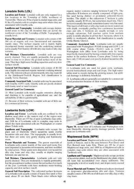
Figure 34 . Aerial view of Lowbanks and Walsingham soils<br />
near Dunnville, showing patchy drainage pattern . Darker<br />
areas are Lowbanks soils<br />
Maplewood <strong>Soil</strong>s (MPW)<br />
Location and Extent Maplewood soils occur in a few places<br />
north of Simcoe, and in the area b<strong>et</strong>ween Port Dover and<br />
Port Burwell near Lake Erie . There are 195 ha of pure<br />
Maplewood map units, and 1008 ha of Maplewood soils in<br />
complex map units where they are often associated with<br />
Tavistock soils .<br />
Landform and Topography Maplewood soils occupy portions<br />
of lacustrine plains, such as the Haldimand clay plain, where<br />
silt loam has accumulated over clayey sediments . The<br />
topography is level or nearly level, and slopes rarely exceed<br />
1 .5% .<br />
Parent Materials and Textures Maplewood soils are developed<br />
on deep-water glaciolacustrine silts and clays. Textures<br />
usually consist of 40-100 cm of silt loam over silty clay or silty<br />
clay loam .


