

Soil Report - Agriculture et Agroalimentaire Canada
Soil Report - Agriculture et Agroalimentaire Canada
Soil Report - Agriculture et Agroalimentaire Canada

You also want an ePaper? Increase the reach of your titles
YUMPU automatically turns print PDFs into web optimized ePapers that Google loves.
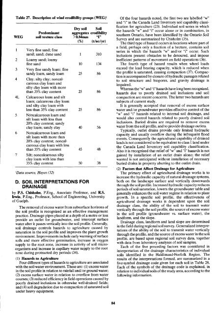
Table 27. Description of wind erodibility groups (WEG)'<br />
Dry soil <strong>Soil</strong><br />
WEG<br />
Predominant<br />
soil texture class<br />
aggregates erodibility<br />
>0.84mm "I"<br />
(%I (t/ac/yr)<br />
1 Very fine sand ; fine<br />
sand ; sand ; dune sand<br />
2 Loamy sand ; loamy<br />
fine sand<br />
3 Very fine sandy loam ; fine<br />
sandy loam, sandy loam<br />
4 Clay ; silty clay ; noncalcareous<br />
clay loam and<br />
silty clay loam with more<br />
than 35% clay content<br />
4L Calcareous loam and silt<br />
loam ; calcareous clay loam<br />
and silty clay loam with<br />
less than 35% clay content<br />
5 Noncalcareous loam and<br />
silt loam with less than<br />
20% clay content; sandy<br />
clay loam ; sandy clay<br />
6 Noncalcareous loam and<br />
silt loam with more than<br />
20% clay content; noncal<br />
careous clay loam with less<br />
than 35% clay content<br />
7 Silt ; noncalcareous silty<br />
clay loam with less than<br />
35% clay content<br />
'Data source, Hayes (32)<br />
D . SOIL INTERPRETATIONS FOR<br />
DRAINAGE<br />
1 310<br />
10 134<br />
25 86<br />
25 86<br />
25 86<br />
40 56<br />
45 48<br />
by P.S . Chisholm, P.Eng., Associate Professor, and R.S .<br />
Irwin, P.Eng ., Professor, School of Engineering, University<br />
of Guelph .<br />
The removal of excess water from subsurface horizons of<br />
the soil profile is recognized as an effective management<br />
practice . Drainage pipes placed at a depth of a m<strong>et</strong>re or less<br />
provide an outl<strong>et</strong> for groundwater, and intercept surface<br />
water after it passes vertically into the soil profile . Generally,<br />
soil drainage controls hazards to agriculture caused by<br />
saturation in the soil profile and improves the plant growth<br />
environment. Improvements include early warming of surface<br />
soils and more effective germination, increase in oxygen<br />
supply to the root zone, increase in activity of soil microorganisms<br />
and increase in capillary water supply to the root<br />
zone during protracted dry periods (34) .<br />
(1) Hazards to <strong>Agriculture</strong><br />
Four different types of hazards to agriculture are associated<br />
with the soil-water environment . These are : (1) excess water<br />
in the soil profile in relation to rainfall and/or ground water ;<br />
(2) excess surface water in relation to overflow from water<br />
courses ; (3) reduced efficiency in field operations caused by<br />
poorly drained inclusions in otherwise well-drained fields ;<br />
and (4) soil degradation due to compaction of saturated soil<br />
under heavy equipment .<br />
50<br />
38<br />
Of the four hazards noted, the first two are labelled "w"<br />
and "i" in the <strong>Canada</strong> Land Inventory soil capability classification<br />
for agriculture (23) . Individual soil series in which<br />
the hazards "w" and "i" occur alone or in combination, in<br />
southern Ontario, have been identified by the Ontario <strong>Soil</strong><br />
Survey and are summarized by Chisholm (35) .<br />
The third type of hazard occurs in locations where part of<br />
a field, perhaps only a fraction of a hectare, contains soil<br />
series in which the hazards "w" and/or "i" occur . Such<br />
inclusions present obstacles to be d<strong>et</strong>oured, and impose<br />
inefficient patterns of movement on field operations (36) .<br />
The fourth type of hazard results when wheel loads<br />
exceed the load bearing capacity, which is reduced when<br />
the profile is saturated, causing compaction (37) . Compaction<br />
is accompanied by closure of hydraulic passages related<br />
to soil structure and biopores, and gravity drainage is<br />
impaired.<br />
Whereas the "w" and "i" hazards have long been recognized,<br />
hazards due to poorly drained soil inclusions and soil<br />
compaction are recent concerns . The latter two hazards are<br />
subjects of current study .<br />
It is generally accepted that removal of excess . surface<br />
water and/or groundwater provides effective control of the<br />
"w" and "i" hazards related to internal soil drainage, and<br />
would also control hazards related to poorly drained soil<br />
inclusions . Buried drains are required to remove excess<br />
water from the soil profile, and to provide drainage outl<strong>et</strong>s .<br />
Typically, outl<strong>et</strong> drains provide only limited hydraulic<br />
capacity and usually overflow during the infrequent flood<br />
events . Consequently the agricultural capability of drained<br />
lands is not considered to be equivalent to class 1 land under<br />
the <strong>Canada</strong> Land Inventory soil capability classification.<br />
Also it is recognized that relief of "w" and "i" hazards is not<br />
gained by installation of an outl<strong>et</strong> drain alone ; the relief<br />
wanted is not anticipated without installation of necessary<br />
buried drains in property abutting to the outl<strong>et</strong> drain .<br />
(2) Factors that Affect Drainage for <strong>Agriculture</strong><br />
The primary effect of agricultural drainage works is to<br />
increase the hydraulic capacity of natural drainage systems,<br />
both on the landscape surface and vertically downwards<br />
through the soil profile . Increased hydraulic capacityreduces<br />
periods of soil saturation, lowers the groundwater table and<br />
generally enhances the soil water regime in relation to plant<br />
growth . In a specific soil profile, the effectiveness of<br />
agricultural drainage works is dependent upon the soil<br />
drainage class, the ability of the soil to transmit water<br />
vertically through the soil profile, the source of excess water<br />
in the soil profile (groundwater vs. surface water), the<br />
landform, and the slope .<br />
Drainage class, landform and land slope are d<strong>et</strong>ermined<br />
in the field during regional soil survey . Generalized interpr<strong>et</strong>ations<br />
of the ability of the soil to transmit water vertically<br />
through the profile, and the source of excess water in the soil<br />
profile, are based upon regional soil survey data, tog<strong>et</strong>her<br />
with data from laboratory analyses of soil samples .<br />
Each of the five preceding factors was considered in<br />
interpr<strong>et</strong>ation of the drainage characteristics of individual<br />
soils identified in the Haldimand-Norfolk Region. The<br />
results of the interpr<strong>et</strong>ations formed, are summarized in a<br />
five-symbol drainage code given for each soil in Table 28 .<br />
Each of the symbols of the drainage code is explained, in<br />
relation to individual soils of the study area, according to the<br />
following information.


