NOT TO BE PRINTED_Draft Final TAAP comments duly
NOT TO BE PRINTED_Draft Final TAAP comments duly
NOT TO BE PRINTED_Draft Final TAAP comments duly

Create successful ePaper yourself
Turn your PDF publications into a flip-book with our unique Google optimized e-Paper software.
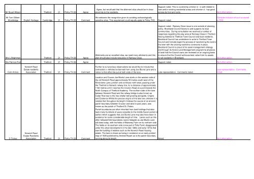
Mr Stuart Wilson Thetford 21 Policy TH 28 Agree<br />
Mr Tom Gilbert-<br />
Wooldridge English Heritage Cambridge 21 Policy TH 28 Comment<br />
Mrs L Brightman Thetford 21 Policy TH 28 Agree<br />
Agree, but would add that the allotment sites should be in close<br />
proximity to the residents.<br />
We welcome the recognition given to avoiding archaeologically<br />
sensitive sites. This requirement could equally apply to Policy TH3. Support noted.<br />
Allotments are an excellent idea, we need more allotments and this<br />
plan should also include new plots in Ramsey Close.<br />
Support noted. This is covered by criterion b - is well related to<br />
new and/or existing residential areas and criterion d - has good<br />
access by foot and cycle. No further action.<br />
Consider inclusion of such a caveat<br />
in TH3.<br />
Support noted. Ramsey Close issue is one outside of planning<br />
policy. Breckland Council listens to and supports its local<br />
communities. During consultation we received a number of<br />
responses regarding the play area at Ramsay Close in Thetford.<br />
Having listened to Thetford Town Council and local residents,<br />
Breckland Council has undertaken to write to Thetford Town<br />
Council and formally begin the process of transferring the land to<br />
the town with the existing restrictive covenants in place.<br />
Breckland Council is proud of its asset management strategy<br />
and through its Active Land Management programme all pieces<br />
of land that the Council owns are reviewed on an ongoing basis<br />
to ensure that the Council achieves best value from its assets<br />
for all residents in Breckland. No further action.<br />
Mrs Patricia Poel Thetford 21 Policy TH 28 Agree Support noted. No further action.<br />
Colin Armes<br />
D Tricker<br />
Norwich Road<br />
Estate residents<br />
Association Thetford 21 Policy TH 29 Comment<br />
Norwich Road<br />
Estate Residents<br />
Association Thetford 21 Policy TH 29 Comment<br />
Further to our previous observations we would like to include that<br />
contractors v vehicles be banned from using Joe Blunts Lane and a<br />
notice to that effect be put at both ends of the lane . Late representation. Comments noted.<br />
Location and Course Joe Blunts Lane starts on the western side of<br />
the old Norwich Road approximately 50 metres south west of the<br />
Kilverstone Lane junction and continues north west, passing under<br />
the Thetford to Norwich railway line, for a distance of approximately<br />
1150 metres until it reaches the Croxton Road at a point beside the<br />
North Campus of Thetford Academy. The northern side of the lane<br />
between Norwich Road and the railway bridge is also known as<br />
Cedar Row due to the tree shelter belt growing alongside. Origins<br />
and Existence Whilst the precise origins of the lane are unknown it is<br />
notable that throughout its length it follows the course of an ancient<br />
parish boundary between Croxton and what in past years, was<br />
known as the parish of Thetford St. Peters.<br />
Late representation. Comments<br />
noted.<br />
Parish boundaries are often inherited from land holdings that date<br />
back many hundreds of years (possibly to the middle Saxon period or<br />
earlier) which suggests that Joe Blunts Lane may also have been in<br />
existence for some considerable length of time. Lanes such as this<br />
often followed field boundaries (some hedged) as Joe Blunts Lane<br />
still does today, with the fields of Blakeney Farm on its northern side.<br />
The fields on its southern side (once part of Folly Farm) disappeared<br />
under the urban development in the late I 960s and early I 970s that<br />
saw the building of estates such as the Norwich Road housing<br />
estate. The lane is shown as being in existence on an early printed<br />
map of 1826 published by Andrew Bryant as is the parish boundary<br />
running along its length. Noted. No further action.