- Page 1 and 2: COOPERATIVE INSTITUTE FOR RESEARCH
- Page 3: Table of Contents Letter from the D
- Page 7 and 8: Executive Summary and Research High
- Page 9 and 10: Executive Summary and Research High
- Page 11 and 12: Executive Summary and Research High
- Page 13 and 14: Chemical Sciences Division (CSD) CI
- Page 15 and 16: CIRES in 2006-2007: Administration
- Page 17 and 18: CIRES in 2006-2007: Contributions t
- Page 19 and 20: CIRES in 2006-2007: Creating a Dyna
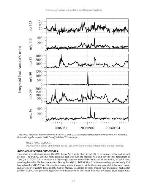
- Page 21 and 22: CIRES in 2006-2007: Creating a Dyna
- Page 23 and 24: CIRES in 2006-2007: Creating a Dyna
- Page 25 and 26: Theme report: Advanced Modeling and
- Page 27: Theme report: Advanced Modeling and
- Page 31 and 32: Theme report: Advanced Modeling and
- Page 33 and 34: Theme report: Advanced Modeling and
- Page 35 and 36: Theme report: Advanced Modeling and
- Page 37 and 38: GSD01: Numerical Weather Prediction
- Page 39 and 40: Theme report: Advanced Modeling and
- Page 41 and 42: Theme report: Advanced Modeling and
- Page 43 and 44: Theme report: Advanced Modeling and
- Page 45 and 46: Theme report: Advanced Modeling and
- Page 47 and 48: Theme report: Advanced Modeling and
- Page 49 and 50: Theme report: Advanced Modeling and
- Page 51 and 52: Theme report: Climate System Variab
- Page 53 and 54: Theme report: Climate System Variab
- Page 55 and 56: Theme report: Climate System Variab
- Page 57 and 58: Theme report: Climate System Variab
- Page 59 and 60: Theme report: Climate System Variab
- Page 61 and 62: Theme report: Climate System Variab
- Page 63 and 64: Theme report: Climate System Variab
- Page 65 and 66: Theme report: Climate System Variab
- Page 67 and 68: Theme report: Climate System Variab
- Page 69 and 70: Theme report: Climate System Variab
- Page 71 and 72: Theme report: Climate System Variab
- Page 73 and 74: NOAA Operation Model NOAA Optimally
- Page 75 and 76: Scientific Theme: Geodynamics This
- Page 77 and 78: Scientific Theme: Geodynamics MILES
- Page 79 and 80:
Scientific Theme: Integrating Activ
- Page 81 and 82:
Scientific Theme: Integrating Activ
- Page 83 and 84:
Scientific Theme: Integrating Activ
- Page 85 and 86:
Scientific Theme: Integrating Activ
- Page 87 and 88:
Scientific Theme: Integrating Activ
- Page 89 and 90:
Scientific Theme: Integrating Activ
- Page 91 and 92:
Scientific Theme: Planetary Metabol
- Page 93 and 94:
Scientific Theme: Planetary Metabol
- Page 95 and 96:
Scientific Theme: Regional Processe
- Page 97 and 98:
CSD08: Regional Air Quality Scienti
- Page 99 and 100:
Scientific Theme: Regional Processe
- Page 101 and 102:
k 1(T) (10 -11 cm 3 molecule -1 s -
- Page 103 and 104:
Scientific Theme: Regional Processe
- Page 105 and 106:
Scientific Theme: Regional Processe
- Page 107 and 108:
Scientific Theme: Regional Processe
- Page 109 and 110:
Global Snow Cover Mapping Richard A
- Page 111 and 112:
Complementary Research: Faculty Fel
- Page 113 and 114:
Land Surface Hydrology and Global C
- Page 115 and 116:
Complementary Research: Faculty Fel
- Page 117 and 118:
Complementary Research: Faculty Fel
- Page 119 and 120:
Complementary Research: Faculty Fel
- Page 121 and 122:
Complementary Research: Faculty Fel
- Page 123 and 124:
Complementary Research: Faculty Fel
- Page 125 and 126:
The Arctic's Shrinking Sea Ice Cove
- Page 127 and 128:
Complementary Research: Faculty Fel
- Page 129 and 130:
Laboratory Studies of Clouds and Ae
- Page 131 and 132:
Complementary Research: Faculty Fel
- Page 133 and 134:
Complementary Research: Faculty Fel
- Page 135 and 136:
Complementary Research: Education a
- Page 137 and 138:
Center for the Study of Earth from
- Page 139 and 140:
Complementary Research: CIRES Scien
- Page 141 and 142:
National Snow and Ice Data Center C
- Page 143 and 144:
Center for Limnology Complementary
- Page 145 and 146:
Climate Diagnostics Center Compleme
- Page 147 and 148:
Complementary Research: Innovative
- Page 149 and 150:
Complementary Research: Innovative
- Page 151 and 152:
Complementary Research: Innovative
- Page 153 and 154:
Complementary Research: Innovative
- Page 155 and 156:
Complementary Research: Innovative
- Page 157 and 158:
Complementary Research: Innovative
- Page 159 and 160:
Complementary Research: CIRES Fello
- Page 161 and 162:
Complementary Research: CIRES Fello
- Page 163 and 164:
CIRES’ Leadership Konrad Steffen:
- Page 165 and 166:
Appendices: Governance and Manageme
- Page 167 and 168:
Appendices: Student Diversity Progr
- Page 169 and 170:
Appendices: Publications Publicatio
- Page 171 and 172:
Appendices: Publications Beaver, M.
- Page 173 and 174:
Appendices: Publications Cimini, D.
- Page 175 and 176:
Appendices: Publications standard u
- Page 177 and 178:
Appendices: Publications Garrett, T
- Page 179 and 180:
Appendices: Publications Holland, M
- Page 181 and 182:
Appendices: Publications Li, S., G.
- Page 183 and 184:
Appendices: Publications Mcguire, A
- Page 185 and 186:
Appendices: Publications Olsen, N.,
- Page 187 and 188:
Appendices: Publications Regonda, S
- Page 189 and 190:
Appendices: Publications Sierau, B.
- Page 191 and 192:
Appendices: Publications Turnbull,
- Page 193 and 194:
Appendices: Publications Yoon, S.C.
- Page 195 and 196:
Appendices: Publications Maus, S.,
- Page 197 and 198:
Appendices: Publications Miller, J.
- Page 199 and 200:
Appendices: Publications Chernogor,
- Page 201 and 202:
Appendices: Publications Petropavlo
- Page 203 and 204:
Appendices: Publications Refereed J
- Page 205 and 206:
Appendices: Honors and Awards Honor
- Page 207 and 208:
Appendices: Honors and Awards Maure
- Page 209 and 210:
Appendices: Service Service: Calend
- Page 211 and 212:
Appendices: Service Army Office of
- Page 213 and 214:
Appendices: Acronyms Acronyms and A
- Page 215 and 216:
Appendices: Acronyms DOE Department
- Page 217 and 218:
Appendices: Acronyms MBBDB MultiBea
- Page 219 and 220:
Appendices: Acronyms SHEBA Surface