

Scientific Theme: Advanced Modeling and Observing Systems
Scientific Theme: Advanced Modeling and Observing Systems
Scientific Theme: Advanced Modeling and Observing Systems

Create successful ePaper yourself
Turn your PDF publications into a flip-book with our unique Google optimized e-Paper software.
<strong>Scientific</strong> <strong>Theme</strong>: Geodynamics<br />
ACCOMPLISHMENTS FOR NGDC05.3:<br />
The two primary reference models for magnetic navigation <strong>and</strong> pointing are<br />
the World Magnetic Model <strong>and</strong> the International Geomagnetic Reference<br />
Field. The CIRES geomagnetism team is strongly involved in producing <strong>and</strong><br />
supporting both of these models. This requires a detailed monitoring of the<br />
time variations of the geomagnetic field. These time variations are captured<br />
in scientific main field models, which are updated every year.<br />
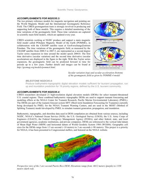
CIRES scientists working at NGDC produce <strong>and</strong> support a main magnetic<br />
field model called POtsdam Magnetic Model of the Earth (POMME), in<br />
collaboration with the CHAMP satellite team at GeoForschungsZentrum<br />
Potsdam. The time variations of the geomagnetic field, as measured by the<br />
CHAMP satellite from 2000.5 to 2007.5, are represented as a second degree<br />
Taylor series expansion in time around the model epoch 2004.0. The first<br />
time derivative (secular variation) <strong>and</strong> the second time derivative (secular<br />
acceleration) are displayed in the figure to the right. With this Taylor series<br />
expansion, the geomagnetic field can be predicted forward in time for<br />
periods up to a few years. Further details <strong>and</strong> images can be found at<br />
http://geomag.org/models/pomme4.html.<br />
Secular variation (top) <strong>and</strong> secular acceleration (bottom)<br />
of the geomagnetic field as given by POMME-4 model<br />
MILESTONE NGDC05.4:<br />
Produce bathymetric-topographic digital elevation models sufficient for tsunami propagation, run<br />
up <strong>and</strong> inundation prediction for 19 priority regions, defined by the U.S. tsunami community.<br />
ACCOMPLISHMENTS FOR NGDC05.4:<br />
CIRES researchers developed 21 high-resolution digital elevation models (DEMs) for select tsunami-threatened<br />
U.S. coastal regions. These combined bathymetric–topographic DEMs are used to support tsunami forecasting <strong>and</strong><br />
modeling efforts at the NOAA Center for Tsunami Research, Pacific Marine Environmental Laboratory (PMEL).<br />
The DEMs are part of the tsunami forecast system SIFT (Short-term Inundation Forecasting for Tsunamis) currently<br />
being developed by PMEL for the NOAA Tsunami Warning Centers, <strong>and</strong> are used in the MOST (Method of<br />
Splitting Tsunami) model developed by PMEL to simulate tsunami generation, propagation, <strong>and</strong> inundation.<br />
Bathymetric, topographic, <strong>and</strong> shoreline data used in DEM compilation are obtained from various sources, including<br />
NGDC, NOAA‘s National Ocean Service (NOS), the U.S. Geological Survey (USGS), the U.S. Army Corps of<br />
Engineers (USACE), the Federal Emergency Management Agency (FEMA), <strong>and</strong> other federal, state, <strong>and</strong> local<br />
government agencies, academic institutions, <strong>and</strong> private companies. DEMs are referenced to the vertical tidal datum<br />
of Mean High Water (MHW) <strong>and</strong> horizontal datum of World Geodetic System 1984 (WGS84). Geographic cell<br />
sizes for the DEMs range from 1/3 arc-second (~10 meters) to 3 arc-seconds (~90 meters). This project is a priority<br />
for NOAA; it has been presented to Congressional staffers, <strong>and</strong> featured on the NOAA website.<br />
Perspective view of the 1 arc-second Puerto Rico DEM. Elevations range from -6612 meters (purple) to 1330<br />
meters (dark red).<br />
70


