

Scientific Theme: Advanced Modeling and Observing Systems
Scientific Theme: Advanced Modeling and Observing Systems
Scientific Theme: Advanced Modeling and Observing Systems

Create successful ePaper yourself
Turn your PDF publications into a flip-book with our unique Google optimized e-Paper software.
<strong>Scientific</strong> <strong>Theme</strong>: Geodynamics<br />
This research also directly supported the International Association of Geomagnetism <strong>and</strong> Aeronomy World Digital<br />
Magnetic Anomaly Map Project (IAGA/WDMAM) <strong>and</strong> studies of crustal magnetism contributing to geodynamic<br />
models of the lithosphere, geologic mapping, <strong>and</strong> natural resource exploration. Inferences from crustal magnetic<br />
field maps, such as the WDMAM, interpreted in conjunction with other information, can help delineate geologic<br />
provinces, locate impact structures, dikes, faults, <strong>and</strong> other geologic entities that have a magnetic contrast with their<br />
surroundings. The Magnetic Anomaly Map of the World, based on the NGDC-720 model, will be published in July<br />
2007 by UNESCO <strong>and</strong> the Commission for the Geological Map of the World.<br />
Products include:<br />
The Extended Magnetic Field Model (EMM-06), including software <strong>and</strong> the main field, secular variation,<br />
NGDC-720-V1 crustal field, magnetospheric field, <strong>and</strong> induced field is now available via on-line access<br />
(http://www.ngdc.noaa.gov/seg/EMM/).<br />
C<strong>and</strong>idate model for the World Digital Magnetic Anomaly Map Project<br />
(http://geomag.org/models/wdmam.html).<br />
MILESTONE NGDC05.2:<br />
Produce a climatological model of the equatorial electrojet by analyzing CHAMP, Ørsted, <strong>and</strong><br />
SAC-C satellite magnetic data.<br />
ACCOMPLISHMENTS FOR NGDC05.2:<br />
69<br />
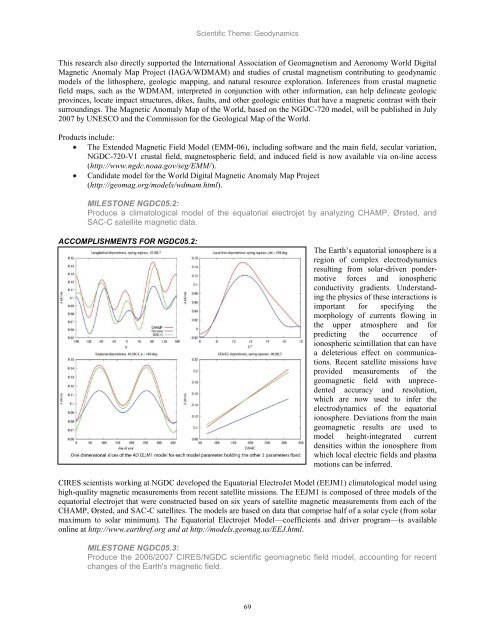
The Earth‘s equatorial ionosphere is a<br />
region of complex electrodynamics<br />
resulting from solar-driven pondermotive<br />
forces <strong>and</strong> ionospheric<br />
conductivity gradients. Underst<strong>and</strong>ing<br />
the physics of these interactions is<br />
important for specifying the<br />
morphology of currents flowing in<br />
the upper atmosphere <strong>and</strong> for<br />
predicting the occurrence of<br />
ionospheric scintillation that can have<br />
a deleterious effect on communications.<br />
Recent satellite missions have<br />
provided measurements of the<br />
geomagnetic field with unprecedented<br />
accuracy <strong>and</strong> resolution,<br />
which are now used to infer the<br />
electrodynamics of the equatorial<br />
ionosphere. Deviations from the main<br />
geomagnetic results are used to<br />
model height-integrated current<br />
densities within the ionosphere from<br />
which local electric fields <strong>and</strong> plasma<br />
motions can be inferred.<br />
CIRES scientists working at NGDC developed the Equatorial ElectroJet Model (EEJM1) climatological model using<br />
high-quality magnetic measurements from recent satellite missions. The EEJM1 is composed of three models of the<br />
equatorial electrojet that were constructed based on six years of satellite magnetic measurements from each of the<br />
CHAMP, Ørsted, <strong>and</strong> SAC-C satellites. The models are based on data that comprise half of a solar cycle (from solar<br />
maximum to solar minimum). The Equatorial Electrojet Model—coefficients <strong>and</strong> driver program—is available<br />
online at http://www.earthref.org <strong>and</strong> at http://models.geomag.us/EEJ.html.<br />
MILESTONE NGDC05.3:<br />
Produce the 2006/2007 CIRES/NGDC scientific geomagnetic field model, accounting for recent<br />
changes of the Earth's magnetic field.


