

Scientific Theme: Advanced Modeling and Observing Systems
Scientific Theme: Advanced Modeling and Observing Systems
Scientific Theme: Advanced Modeling and Observing Systems

You also want an ePaper? Increase the reach of your titles
YUMPU automatically turns print PDFs into web optimized ePapers that Google loves.
<strong>Theme</strong> report: <strong>Advanced</strong> <strong>Modeling</strong> <strong>and</strong> <strong>Observing</strong> <strong>Systems</strong><br />
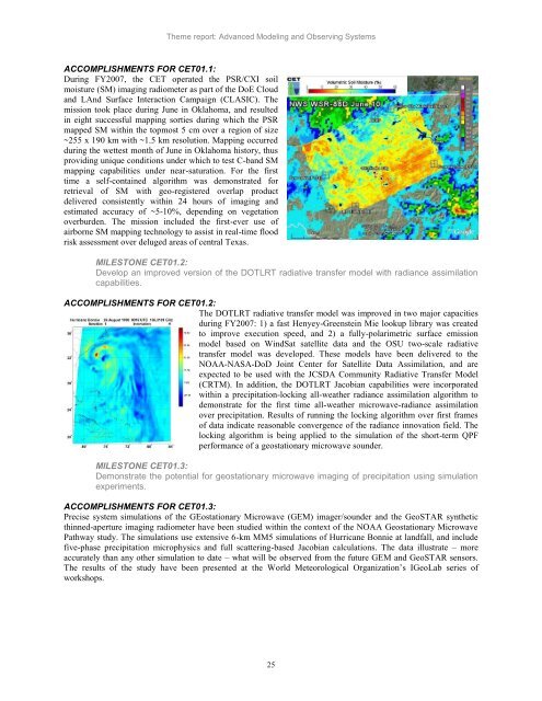
ACCOMPLISHMENTS FOR CET01.1:<br />
During FY2007, the CET operated the PSR/CXI soil<br />
moisture (SM) imaging radiometer as part of the DoE Cloud<br />
<strong>and</strong> LAnd Surface Interaction Campaign (CLASIC). The<br />
mission took place during June in Oklahoma, <strong>and</strong> resulted<br />
in eight successful mapping sorties during which the PSR<br />
mapped SM within the topmost 5 cm over a region of size<br />
~255 x 190 km with ~1.5 km resolution. Mapping occurred<br />
during the wettest month of June in Oklahoma history, thus<br />
providing unique conditions under which to test C-b<strong>and</strong> SM<br />
mapping capabilities under near-saturation. For the first<br />
time a self-contained algorithm was demonstrated for<br />
retrieval of SM with geo-registered overlap product<br />
delivered consistently within 24 hours of imaging <strong>and</strong><br />
estimated accuracy of ~5-10%, depending on vegetation<br />
overburden. The mission included the first-ever use of<br />
airborne SM mapping technology to assist in real-time flood<br />
risk assessment over deluged areas of central Texas.<br />
MILESTONE CET01.2:<br />
Develop an improved version of the DOTLRT radiative transfer model with radiance assimilation<br />
capabilities.<br />
ACCOMPLISHMENTS FOR CET01.2:<br />
The DOTLRT radiative transfer model was improved in two major capacities<br />
during FY2007: 1) a fast Henyey-Greenstein Mie lookup library was created<br />
to improve execution speed, <strong>and</strong> 2) a fully-polarimetric surface emission<br />
model based on WindSat satellite data <strong>and</strong> the OSU two-scale radiative<br />
transfer model was developed. These models have been delivered to the<br />
NOAA-NASA-DoD Joint Center for Satellite Data Assimilation, <strong>and</strong> are<br />
expected to be used with the JCSDA Community Radiative Transfer Model<br />
(CRTM). In addition, the DOTLRT Jacobian capabilities were incorporated<br />
within a precipitation-locking all-weather radiance assimilation algorithm to<br />
demonstrate for the first time all-weather microwave-radiance assimilation<br />
over precipitation. Results of running the locking algorithm over first frames<br />
of data indicate reasonable convergence of the radiance innovation field. The<br />
locking algorithm is being applied to the simulation of the short-term QPF<br />
performance of a geostationary microwave sounder.<br />
MILESTONE CET01.3:<br />
Demonstrate the potential for geostationary microwave imaging of precipitation using simulation<br />
experiments.<br />
ACCOMPLISHMENTS FOR CET01.3:<br />
Precise system simulations of the GEostationary Microwave (GEM) imager/sounder <strong>and</strong> the GeoSTAR synthetic<br />
thinned-aperture imaging radiometer have been studied within the context of the NOAA Geostationary Microwave<br />
Pathway study. The simulations use extensive 6-km MM5 simulations of Hurricane Bonnie at l<strong>and</strong>fall, <strong>and</strong> include<br />
five-phase precipitation microphysics <strong>and</strong> full scattering-based Jacobian calculations. The data illustrate – more<br />
accurately than any other simulation to date – what will be observed from the future GEM <strong>and</strong> GeoSTAR sensors.<br />
The results of the study have been presented at the World Meteorological Organization‘s IGeoLab series of<br />
workshops.<br />
25


