

Scientific Theme: Advanced Modeling and Observing Systems
Scientific Theme: Advanced Modeling and Observing Systems
Scientific Theme: Advanced Modeling and Observing Systems

Create successful ePaper yourself
Turn your PDF publications into a flip-book with our unique Google optimized e-Paper software.
<strong>Scientific</strong> <strong>Theme</strong>: Geodynamics<br />
MILESTONE NGDC05.5:<br />
Provide community with web access to bathymetric-topographic grids developed for tsunami<br />
prediction as st<strong>and</strong>ard products, with documentation of procedures, analysis, quality control <strong>and</strong><br />
quality assessment of data.<br />
ACCOMPLISHMENTS FOR NGDC05.5:<br />
CIRES scientists at NGDC developed the ―NGDC Tsunami Inundation Gridding Project‖ website<br />
(http://www.ngdc.noaa.gov/mgg/inundation/) for public access of tsunami inundation DEMs. On this site, visitors<br />
may download completed DEMs, with corresponding metadata <strong>and</strong> documentation. The site also identifies coastal<br />
communities for which bathymetric–topographic DEMs are planned to be built in the future.<br />
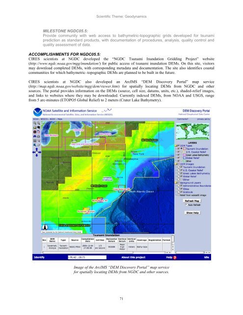
CIRES scientists at NGDC also developed an ArcIMS ―DEM Discovery Portal‖ map service<br />
(http://map.ngdc.noaa.gov/website/mgg/dem/viewer.htm) for spatially locating DEMs from NGDC <strong>and</strong> other<br />
sources. The portal provides information on the DEMs (source, cell size, datums, units, etc.), shaded-relief images,<br />
<strong>and</strong> links to websites where they may be downloaded. Currently indexed DEMs, from NOAA <strong>and</strong> USGS, range<br />
from 5 arc-minutes (ETOPO5 Global Relief) to 2 meters (Crater Lake Bathymetry).<br />
Image of the ArcIMS ―DEM Discovery Portal‖ map service<br />
for spatially locating DEMs from NGDC <strong>and</strong> other sources.<br />
71


