BOARD OF COUNTY COMMISSIONERS LEON COUNTY, FLORIDA
BOARD OF COUNTY COMMISSIONERS LEON COUNTY, FLORIDA
BOARD OF COUNTY COMMISSIONERS LEON COUNTY, FLORIDA
Create successful ePaper yourself
Turn your PDF publications into a flip-book with our unique Google optimized e-Paper software.
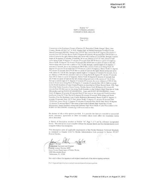
Exhibit "A"<br />
NEW CYPRESS LANDING<br />
CONSERVATION AREA#4<br />
Description<br />
Page 1 of3<br />
Attachment #1<br />
Page 14 of 20<br />
Commence at the Southwest Comer of Section 23, Township 2 North, Range 3 East, Leon<br />
County, Florida. (FCM 3"x3" X-TOP, Florida Dept. of Natural Resources Cetiified Comer<br />
Record Document #45558). Thence East 2333 .07 feet; thence North 47 degrees 28 minutes 51<br />
seconds East 623.50 feel; thence North 21degrees 40 ·minutes 40 seconds East 1596.84 feet to a<br />
point of curve to the right; thence along said curve with a radius of 716.20 feet, through a central<br />
angle of 36 degrees 33 minutes 39 seconds, for an arc distance of 457.01 feet, (chord of said<br />
curve being North 39 degrees 57 minutes 29 seconds East 449.30 feet) to a point of tangency;<br />
thence N01th 58 degrees 14 minutes 19 seconds East 48.69 feet to a point of curve to the left;<br />
thence along said curve with a radius of 7 42 .76 feet, through a central angle of 26 degrees 17<br />
minutes 57 seconds, for an arc distance of 340.93 feet, (chord of said curve being North 45<br />
degrees 05 minutes 20 seconds East 337.95 feet) to a point of tangency; thence North 31 degrees<br />
56 minutes 22 seconds East 278.18 feet to a point of curve to the right; thence along said curve<br />
with radius of 1738.40 feet, through a central angle of 16 degrees 22 minutes 02 seconds, for an<br />
arc distance of 496.60 feet, (chord of said curve being North 40 degrees 07 minutes 23 seconds<br />
East 494.21 feet) to a point of tangency; thence North 48 degrees18 minutes 24 seconds East<br />
28.19 feet to a point of curve to the left; thence along said curve with a radius of716.20 feet,<br />
through a central angle of 31 degrees 13 minutes 03 seconds, for an arc distance of 390.22 feet,<br />
(chord of said curve being North 32 degrees 41 minutes 23 seconds East 385.41 feet) to a point<br />
on the South boundary of Leon County Propet1y as described in Official Record Book 1950, Page<br />
226 of the Public Records of Leon County, Florida; thence North 90 degrees 00 minutes 00<br />
seconds East 436 feet more or less along South boundary to the Ordinary High Waterline of Lake<br />
Miccosukee and the POINT <strong>OF</strong> BEGINNING. From said POINT <strong>OF</strong> BEGINNING, thence<br />
North 90 degrees 00 minutes 00 seconds West 47 feet more or less along said South boundary<br />
(said point lying 26.73 feet N01th 90 degrees 00 minutes 00 seconds West along said South<br />
boundary from the Southeast Leon County Reference Monument); thence North 01 degrees 13<br />
minutes 48 seconds West 192.57 feet; thence Notih 12 degrees 51 minutes 28 seconds East<br />
138.86 feet; thence North 19 degrees 55 minutes 03 seconds East 184.95 feet; North 49 degrees<br />
16 minutes 52 seconds East 57 feet more or less to the Ordinary High Waterline of Lake<br />
Miccosukee; thence Southerly along said Ordinary High Water Mark of Lake Miccosukee to the<br />
POINT <strong>OF</strong> BEGINNING. Containing 1.028 acres more or less.<br />
No abstract of title or title opinion provided. It is possible that there are recorded or unrecorded<br />
deeds, easements, agreements or other instruments which could affect the boundaries herein<br />
above described.<br />
A Sketch of Description attached as Exhibit "A", Page 3 of 3 and by reference incorporated<br />
herein. This description is not complete without the attached sketch and the attached sketch is not<br />
complete without the description.<br />
This description meets all applicable requirements of the Florida Minimum Technical Standards<br />
as contained in Chapter 61G17-6 Florida Administrative Code pursl.l':il1t to Section 472.027<br />
Florida Statutes.<br />
rofcssional Surveyor and Mapper<br />
r-lorida License Number 6059<br />
Leon County Department of Public Works<br />
2280 Miccosukee Road<br />
Tallahassee, FL 32308<br />
Not valid without the signature and original raised seal of the above signing surveyor.<br />
File:C:\Eagl epoinlProjecls\NewCyressLnnding\Conservalion Ensmenl\NewCylessLegol-4.doc<br />
Page 79 of 282 Posted at 5:00 p.m. on August 31, 2012


