

environmental assessment for the hog lake road improvement project
environmental assessment for the hog lake road improvement project
environmental assessment for the hog lake road improvement project

Create successful ePaper yourself
Turn your PDF publications into a flip-book with our unique Google optimized e-Paper software.
Ramona Hog Lake Road Improvement Project August 2011<br />
proposed <strong>project</strong> was requested by <strong>the</strong> Sovereign Nation of <strong>the</strong> Ramona Tribe<br />
and <strong>the</strong> RTA. It would cross Federal Forest System lands and is funded by Tribal<br />
government.<br />
One comment additionally requested in<strong>for</strong>mation be more available in <strong>the</strong> local<br />
Anza publications. The <strong>project</strong> mailing list has been updated with <strong>the</strong> local<br />
contacts requested.<br />
Chapter 2 – Alternatives<br />
This chapter describes and compares <strong>the</strong> alternatives considered <strong>for</strong> <strong>the</strong> Hog Lake<br />
Road Improvement Project EA. It describes both alternatives considered in detail<br />
and those eliminated from detailed study. The end of this chapter presents <strong>the</strong><br />
alternatives in a table so that <strong>the</strong> alternatives and <strong>the</strong>ir <strong>environmental</strong> impacts can be<br />
readily compared.<br />
The Proposed Action Alternative<br />
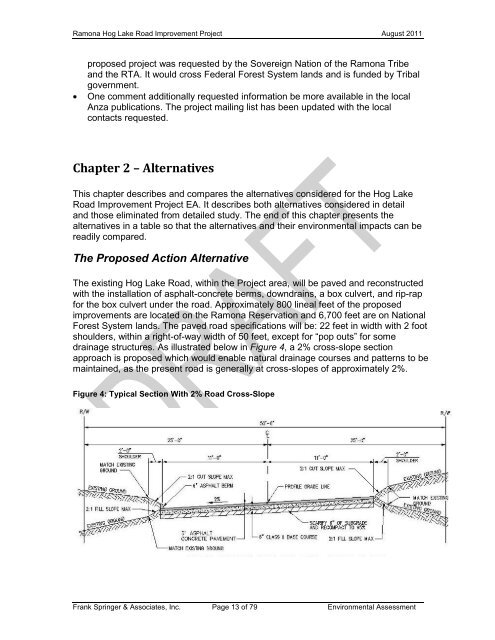
The existing Hog Lake Road, within <strong>the</strong> Project area, will be paved and reconstructed<br />
with <strong>the</strong> installation of asphalt-concrete berms, downdrains, a box culvert, and rip-rap<br />
<strong>for</strong> <strong>the</strong> box culvert under <strong>the</strong> <strong>road</strong>. Approximately 800 lineal feet of <strong>the</strong> proposed<br />
<strong>improvement</strong>s are located on <strong>the</strong> Ramona Reservation and 6,700 feet are on National<br />
Forest System lands. The paved <strong>road</strong> specifications will be: 22 feet in width with 2 foot<br />
shoulders, within a right-of-way width of 50 feet, except <strong>for</strong> “pop outs” <strong>for</strong> some<br />
drainage structures. As illustrated below in Figure 4, a 2% cross-slope section<br />
approach is proposed which would enable natural drainage courses and patterns to be<br />
maintained, as <strong>the</strong> present <strong>road</strong> is generally at cross-slopes of approximately 2%.<br />
Figure 4: Typical Section With 2% Road Cross-Slope<br />
Frank Springer & Associates, Inc. Page 13 of 79 Environmental Assessment


