Supporting documents - Renfrewshire Council
Supporting documents - Renfrewshire Council
Supporting documents - Renfrewshire Council

You also want an ePaper? Increase the reach of your titles
YUMPU automatically turns print PDFs into web optimized ePapers that Google loves.
2. DEVELOPMENT PROPOSAL DESCRIPTION<br />
2.1 Site location<br />
Dawn Developments Ltd/467374673/Queen’s Quay Masterplan EIA/KD<br />
04/01/2012<br />
Major Mixed Use Development, Queen's Quay, Clydebank<br />
EIA Scoping Report<br />
The Development site is situated in the town of Clydebank on the north bank of the River<br />
Clyde. The site is centred on OS Grid reference NS 4950 6990 (see Figure 1, Appendix<br />
B).<br />
The site is bounded by the River Clyde to the south-west; Queen’s Quay Enterprise and<br />
Learning District/ Queen’s Gate residential development to the south-east; undeveloped<br />
land and light industry/ commercial properties along Cable Depot Road to the north; and<br />
the A814 Glasgow Road/ residential, commercial and civic properties along Dumbarton<br />
Road to the northeast and east.<br />
The site is generally flat but there is a gentle gradient (typically falling south-east to northwest)<br />
from Dumbarton Road down towards the River Clyde. Ground levels range<br />
between 8.7m above ordnance datum (AOD) (in the north-eastern corner of the site at<br />
the Dumbarton Road boundary) and 4.5m AOD (at the quayside). The majority of the site,<br />
north-west of the Queen’s Dock, is lower than 5.7m AOD.<br />
The site is underlain by made ground deposited in the 19 th century during the original<br />
development of the greenfield site to raise the existing ground level and accommodate<br />
the dock infrastructure. The natural drift deposits below the made ground comprise<br />
alluvium overlying glacial till. The bedrock is mudstone, believed to be part of the<br />
Lawmuir Formation (sandstones and mudstones with thin bands of limestone and coal<br />
measures).<br />
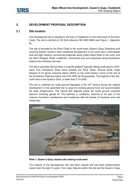
Plate 1: Queen’s Quay cleared site looking north-west<br />
The majority of the Development site has been cleared and has been predominantly<br />
vacant over the past 10 years. Two major features within the site are the Queen’s Quay<br />
Page 5<br />
Final for Issue