DHIJWASv Software FEFLOW 6.1
DHIJWASv Software FEFLOW 6.1
DHIJWASv Software FEFLOW 6.1

Create successful ePaper yourself
Turn your PDF publications into a flip-book with our unique Google optimized e-Paper software.
QK=tçêâáåÖ=ïáíÜ=j~éë<br />
OM=ö=rëÉê=j~åì~ä<br />
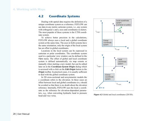
QKO `ççêÇáå~íÉ=póëíÉãë<br />
Dealing with spatial data requires the definition of a<br />
unique coordinate system as a reference. <strong>FEFLOW</strong> can<br />
use data in any metric cartesian system, i.e., any system<br />
with orthogonal x and y axes and coordinates in meters.<br />
The most popular of these systems is the UTM coordinate<br />
system.<br />
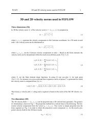
To achieve better precision in the calculations,<br />
<strong>FEFLOW</strong> always uses a local and a global coordinate<br />
system at the same time. The axes in both systems have<br />
the same orientation, only the origin of the local system<br />
has an offset in global coordinates.<br />
Locations in the local system can be expressed in<br />
cartesian or polar coordinates. The coordinate system<br />
used in a particular view window can be defined in the<br />
View menu. The offset of global and local coordinate<br />
system is defined automatically via map extents or<br />
manually when starting a new model, but can be edited<br />
later on in the Coordinate-System Origin dialog which<br />
is accessed with a click on the Edit Origin button in the<br />
Origin toolbar. In practical cases, it is usually sufficient<br />
to deal with the global coordinate system.<br />
In 2D cross-sectional and axisymmetric models the<br />
y coordinate refers to the elevation. In these cases an<br />
offset between local and global coordinates in y should<br />
be avoided so that there is no doubt about the elevation<br />
reference. Internally, <strong>FEFLOW</strong> uses the local y coordinate<br />
as the reference for elevation-dependent parameters,<br />
e.g., when converting hydraulic head to pressure<br />
head and vice versa.<br />
Figure 4.2 Global and local coordinates (2D/3D).