AFRTS Defense Media Center Satellite Handbook
AFRTS Defense Media Center Satellite Handbook
AFRTS Defense Media Center Satellite Handbook

You also want an ePaper? Increase the reach of your titles
YUMPU automatically turns print PDFs into web optimized ePapers that Google loves.
<strong>Defense</strong> <strong>Media</strong> <strong>Center</strong> <strong>Satellite</strong> <strong>Handbook</strong> V.3.26<br />
Chapter 5 Procedures for finding the <strong>AFRTS</strong> ® digital<br />
satellite signals<br />
The intent of this section is to aid in overcoming the difficulties of pointing a<br />
satellite antenna at an object 22,300 miles from earth. It contains step-by-step<br />
satellite dish pointing guidance, receiver setup procedures and a trouble-shooting<br />
guide. It is understood there are varying degrees of experience in setting up<br />
satellite systems, so this is written as a general procedure. Take a couple of<br />
minutes to read and familiarize yourself with the content of this section before<br />
making adjustments to your system. If the dish is installed in military housing or<br />
where other <strong>AFRTS</strong> dishes are installed one can get an idea of the compass<br />
heading (azimuth) and elevation that others are using. It is important to<br />
understand that the dish must be accurately pointed and the set-top receiver<br />
correctly programmed before signals may be received.<br />
There are currently four different models of digital IRD’s: two consumer set-top<br />
models and two commercial quality rack mount models. Please be aware that<br />
there are setup differences and they are noted where appropriate though out this<br />
chapter. Appendix D of this document will list out the receiver settings for each<br />
receiver and area around the world.<br />
Obtaining your site Azimuth and Elevation<br />
Aiming a satellite antenna is basically the same principle used to aim a TV<br />
antenna, with just a few new terms to deal with. Direction to a satellite from an<br />
earth station site is typically expressed as “Azimuth”, the compass heading East<br />
or West in the site horizontal plane, and “Elevation”, the angular amount up from<br />
the site horizon, or the angular amount of tilt. The larger the antenna, the more<br />
critical it becomes to aim accurately, but offers more gain and therefore better<br />
signal reception. If you can’t find information in appendix C regarding your site<br />
azimuth and elevation, call HQ <strong>AFRTS</strong> at commercial (703) 428-0268, DSN 328-<br />
0268 or the <strong>AFRTS</strong>-BC 24 hours a day at commercial (951) 413-2236, DSN 348-<br />
1236.<br />
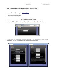
Step One: IRD Authorization<br />
The first step in getting your IRD to work is to have its Tracking Identification<br />
(TID) number entered in the <strong>AFRTS</strong> decoder database by logging into<br />
https://pvconnect.net, if Internet service is not available call <strong>AFRTS</strong>-BC 24 hours<br />
a day at (951) 413-2339, DSN 348-1339 or <strong>AFRTS</strong>-HQ during normal working<br />
hours east coast time at (703) 428-0616, DSN 328-0616.<br />
Step Two: Finding a Clear line of Sight<br />
(a) Two tools are required to survey your site location, a magnetic compass,<br />
and angle locator. If you can’t locate an angle finder gauge see figure 5-6,<br />
“Use of Protractor”.<br />
(b) Go outside to the antenna site and hold your compass flat in your hand.<br />
Rotate the compass to get the ”N” (north) and the pointer to align, see<br />
5-1