

Neil D. Burgess, Paul Harrison, Peter Sumbi, James Laizer, Adam ...
Neil D. Burgess, Paul Harrison, Peter Sumbi, James Laizer, Adam ...
Neil D. Burgess, Paul Harrison, Peter Sumbi, James Laizer, Adam ...

Create successful ePaper yourself
Turn your PDF publications into a flip-book with our unique Google optimized e-Paper software.
SPATIAL PLANNING BASELINE: TANZANIA’S COASTAL FORESTS 2011<br />
A broad consultation with stakeholders from this landscape in 2011 (Kashaigili et al. 2011) identified and<br />
mapped the remaining corridors, which are:<br />
Selous Game Reserve (GR)–Tapika–Kichi–Katundu FR–Rufiji River<br />
Tawi–Kiwengoma–Namakutwa FR–Tamburu–Kiwanga and then cross the main tarmac road.<br />
Tawi–Kitope–Somanga–Simu (Sanduku FR). This corridor is followed during the breeding season.<br />
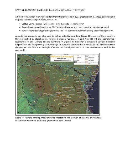
A modelling approach was also used to define potential corridors (Figure 10); some of these confirm<br />
those identified by stakeholders, notably between Rupiange FR and Kichi Hill FR and Namakutwa-<br />
Nyamwete FR and Mohoro FR and Tamburu FR (Figure 9). However, a simulated corridor between<br />
Kingoma FR and Mangroves passes through settlements because that is the least cost route between<br />
the two patches. This is an example of where the model produces a corridor which cannot work in the<br />
real world.<br />
Figure 9: Remote sensing image showing vegetation and location of reserves and villages<br />
in Matumbi-Kichi Hills landscape (from Perkin et al. 2008a)


