

Chapter 1 Minimum Flows and Levels - Southwest Florida Water ...
Chapter 1 Minimum Flows and Levels - Southwest Florida Water ...
Chapter 1 Minimum Flows and Levels - Southwest Florida Water ...

You also want an ePaper? Increase the reach of your titles
YUMPU automatically turns print PDFs into web optimized ePapers that Google loves.
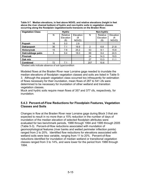
Table 5-7. Median elevations, in feet above NGVD, <strong>and</strong> relative elevations (height in feet<br />
above the river channel bottom) of hydric <strong>and</strong> non-hydric soils in vegetation classes<br />
occurring along the floodplain vegetation/soils transects on the Braden River.<br />
Vegetation Class<br />
Hydric<br />
Non-hydric<br />
N Relative<br />
Elevation<br />
(ft)<br />
Elevation<br />
(ft<br />
NGVD)<br />
N Relative<br />
Elevation<br />
(ft)<br />
Elevation<br />
(ft<br />
NGVD)<br />
Popash 16 5.0 2.8<br />
Oak/popash 36 7.1 19.9 2 6.8 21.8<br />
Hickory/oak 15 7.8 25.2 53 9.1 15.8<br />
Oak/cabbage palm 5 9.4 18.0 99 9.4 24.5<br />
Pine/oak 24 14.3 19.5<br />
Oak mix 27 13.3 11.1<br />
Combined 72 7.1 207 10.6<br />
*Shaded cells indicate absence of soil type/condition<br />
Modeled flows at the Braden River near Lorraine gage needed to inundate the<br />
median elevations of floodplain vegetation classes <strong>and</strong> soils are listed in Table 5-<br />
3. Although the popash vegetation class occurred too infrequently for estimation<br />
of flows necessary for their inundation, mean flows of 287 to 541 cfs were<br />
determined to be necessary for inundation of other wetl<strong>and</strong> <strong>and</strong> transition<br />
vegetation classes.<br />
Muck <strong>and</strong> hydric soils require mean flows of 357 <strong>and</strong> 377 cfs, respectively, for<br />
inundation.<br />
5.4.3 Percent-of-Flow Reductions for Floodplain Features, Vegetation<br />
Classes <strong>and</strong> Soils<br />
Changes in flow at the Braden River near Lorraine gage during Block 3 that are<br />
expected to result in no more than a 15% reduction in the number of days of<br />
inundation of the median elevation of selected floodplain attributes were<br />
evaluated for two benchmark periods, 1988 through 1994 <strong>and</strong> 1995 through 2005<br />
(Table 5-3). Percent-of-flow reductions associated with inundation of<br />
geomorphological features (river banks <strong>and</strong> wetted perimeter inflection points)<br />
ranged from 2 to 20%. Identified flow reductions for elevations associated with<br />
wetl<strong>and</strong> soils were less variable, ranging from 11 to 20%. Percent-of-flow<br />
reductions identified for inundation of median wetl<strong>and</strong> or transitional vegetation<br />
classes ranged from 3 to 14%, <strong>and</strong> were lower for the period from 1988 through<br />
1994.<br />
5-15


