

Chapter 1 Minimum Flows and Levels - Southwest Florida Water ...
Chapter 1 Minimum Flows and Levels - Southwest Florida Water ...
Chapter 1 Minimum Flows and Levels - Southwest Florida Water ...

Create successful ePaper yourself
Turn your PDF publications into a flip-book with our unique Google optimized e-Paper software.
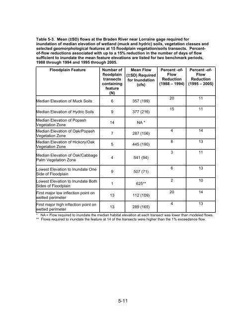
Table 5-3. Mean (±SD) flows at the Braden River near Lorraine gage required for<br />
inundation of median elevation of wetl<strong>and</strong> (muck <strong>and</strong> hydric) soils, vegetation classes <strong>and</strong><br />
selected geomorphological features at 15 floodplain vegetation/soils transects. Percentof-flow<br />
reductions associated with up to a 15% reduction in the number of days of flow<br />
sufficient to inundate the mean feature elevations are listed for two benchmark periods,<br />
1988 through 1994 <strong>and</strong> 1995 through 2005.<br />
Floodplain Feature<br />
Number of<br />
floodplain<br />
transects<br />
containing<br />
feature<br />
(N)<br />
Mean Flow<br />
(±SD) Required<br />
for Inundation<br />
(cfs)<br />
Median Elevation of Muck Soils 6 357 (199)<br />
Median Elevation of Hydric Soils 9 377 (216)<br />
Percent -of-<br />
Flow<br />
Reduction<br />
(1988 – 1994)<br />
Percent -of-<br />
Flow<br />
Reduction<br />
(1995 – 2005)<br />
20 11<br />
15 11<br />
Median Elevation of Popash<br />
Vegetation Zone<br />
Median Elevation of Oak/Popash<br />
Vegetation Zone<br />
Median Elevation of Hickory/Oak<br />
Vegetation Zone<br />
Median Elevation of Oak/Cabbage<br />
Palm Vegetation Zone<br />
14 NA *<br />
7 287 (106)<br />
5 445 (190)<br />
4 541 (94)<br />
4 14<br />
8 13<br />
3 11<br />
Lowest Elevation to Inundate One<br />
6 13<br />
9 507 (71)<br />
Side of Floodplain<br />
Lowest Elevation to Inundate Both<br />
2 10<br />
1 625**<br />
Sides of Floodplain<br />
First major low inflection point on<br />
20 14<br />
13 112 (109)<br />
wetted perimeter<br />
First major high inflection point on<br />
4 13<br />
13 289 (165)<br />
wetted perimeter<br />
* NA = Flow required to inundate the median habitat elevation at each transect was lower than modeled flows.<br />
** <strong>Flows</strong> required to inundate the feature at 14 of the transects were higher than the 1% exceedance flow.<br />
5-11


