

Chapter 1 Minimum Flows and Levels - Southwest Florida Water ...
Chapter 1 Minimum Flows and Levels - Southwest Florida Water ...
Chapter 1 Minimum Flows and Levels - Southwest Florida Water ...

You also want an ePaper? Increase the reach of your titles
YUMPU automatically turns print PDFs into web optimized ePapers that Google loves.
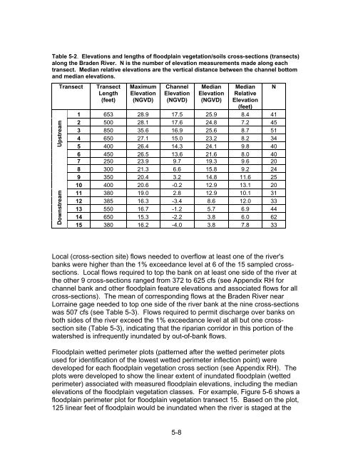
Table 5-2. Elevations <strong>and</strong> lengths of floodplain vegetation/soils cross-sections (transects)<br />
along the Braden River. N is the number of elevation measurements made along each<br />
transect. Median relative elevations are the vertical distance between the channel bottom<br />
<strong>and</strong> median elevations.<br />
Downstream Upstream<br />
Transect<br />
Transect<br />
Length<br />
(feet)<br />
Maximum<br />
Elevation<br />
(NGVD)<br />
Channel<br />
Elevation<br />
(NGVD)<br />
Median<br />
Elevation<br />
(NGVD)<br />
Median<br />
Relative<br />
Elevation<br />
(feet)<br />
1 653 28.9 17.5 25.9 8.4 41<br />
2 500 28.1 17.6 24.8 7.2 45<br />
3 850 35.6 16.9 25.6 8.7 51<br />
4 650 27.1 15.0 23.2 8.2 34<br />
5 400 26.4 14.3 24.1 9.8 40<br />
6 450 26.5 13.6 21.6 8.0 40<br />
7 250 23.9 9.7 19.3 9.6 20<br />
8 300 21.3 6.6 15.8 9.2 24<br />
9 350 20.4 3.2 14.8 11.6 25<br />
10 400 20.6 -0.2 12.9 13.1 20<br />
11 380 19.0 2.8 12.9 10.1 31<br />
12 385 16.3 -3.4 8.6 12.0 33<br />
13 550 16.7 -1.2 5.7 6.9 44<br />
14 650 15.3 -2.2 3.8 6.0 62<br />
15 380 16.2 -4.0 3.8 7.8 33<br />
N<br />
Local (cross-section site) flows needed to overflow at least one of the river's<br />
banks were higher than the 1% exceedance level at 6 of the 15 sampled crosssections.<br />
Local flows required to top the bank on at least one side of the river at<br />
the other 9 cross-sections ranged from 372 to 625 cfs (see Appendix RH for<br />
channel bank <strong>and</strong> other floodplain feature elevations <strong>and</strong> associated flows for all<br />
cross-sections). The mean of corresponding flows at the Braden River near<br />
Lorraine gage needed to top one side of the river bank at the nine cross-sections<br />
was 507 cfs (see Table 5-3). <strong>Flows</strong> required to permit discharge over banks on<br />
both sides of the river exceed the 1% exceedance level at all but one crosssection<br />
site (Table 5-3), indicating that the riparian corridor in this portion of the<br />
watershed is infrequently inundated by out-of-bank flows.<br />
Floodplain wetted perimeter plots (patterned after the wetted perimeter plots<br />
used for identification of the lowest wetted perimeter inflection point) were<br />
developed for each floodplain vegetation cross section (see Appendix RH). The<br />
plots were developed to show the linear extent of inundated floodplain (wetted<br />
perimeter) associated with measured floodplain elevations, including the median<br />
elevations of the floodplain vegetation classes. For example, Figure 5-6 shows a<br />
floodplain perimeter plot for floodplain vegetation transect 15. Based on the plot,<br />
125 linear feet of floodplain would be inundated when the river is staged at the<br />
5-8


