

Chapter 1 Minimum Flows and Levels - Southwest Florida Water ...
Chapter 1 Minimum Flows and Levels - Southwest Florida Water ...
Chapter 1 Minimum Flows and Levels - Southwest Florida Water ...

Create successful ePaper yourself
Turn your PDF publications into a flip-book with our unique Google optimized e-Paper software.
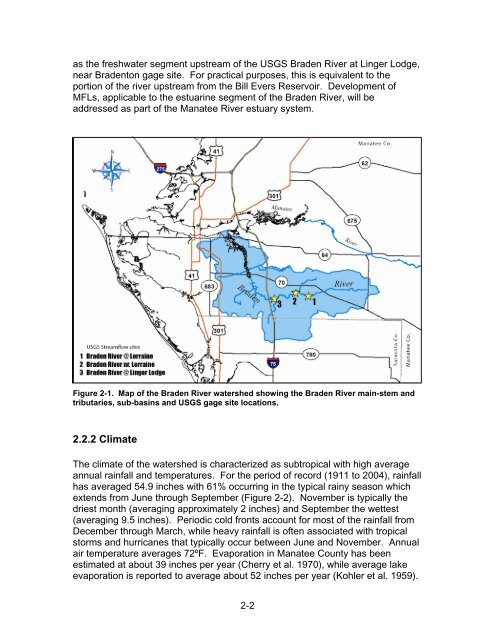
as the freshwater segment upstream of the USGS Braden River at Linger Lodge,<br />
near Bradenton gage site. For practical purposes, this is equivalent to the<br />
portion of the river upstream from the Bill Evers Reservoir. Development of<br />
MFLs, applicable to the estuarine segment of the Braden River, will be<br />
addressed as part of the Manatee River estuary system.<br />
Figure 2-1. Map of the Braden River watershed showing the Braden River main-stem <strong>and</strong><br />
tributaries, sub-basins <strong>and</strong> USGS gage site locations.<br />
2.2.2 Climate<br />
The climate of the watershed is characterized as subtropical with high average<br />
annual rainfall <strong>and</strong> temperatures. For the period of record (1911 to 2004), rainfall<br />
has averaged 54.9 inches with 61% occurring in the typical rainy season which<br />
extends from June through September (Figure 2-2). November is typically the<br />
driest month (averaging approximately 2 inches) <strong>and</strong> September the wettest<br />
(averaging 9.5 inches). Periodic cold fronts account for most of the rainfall from<br />
December through March, while heavy rainfall is often associated with tropical<br />
storms <strong>and</strong> hurricanes that typically occur between June <strong>and</strong> November. Annual<br />
air temperature averages 72ºF. Evaporation in Manatee County has been<br />
estimated at about 39 inches per year (Cherry et al. 1970), while average lake<br />
evaporation is reported to average about 52 inches per year (Kohler et al. 1959).<br />
2-2


