Living with Risk. A global review of disaster reduction initiatives
Living with Risk. A global review of disaster reduction initiatives
Living with Risk. A global review of disaster reduction initiatives

Create successful ePaper yourself
Turn your PDF publications into a flip-book with our unique Google optimized e-Paper software.
2<br />
<strong>Living</strong> <strong>with</strong> <strong>Risk</strong>: A <strong>global</strong> <strong>review</strong> <strong>of</strong> <strong>disaster</strong> <strong>reduction</strong> <strong>initiatives</strong><br />
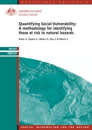
Community risks in Australia<br />
aspects <strong>of</strong> vulnerability/capacity, especially<br />
those related to the social nature <strong>of</strong> these concepts,<br />
pose a different range <strong>of</strong> challenges to<br />
risk assessment.<br />
Often there is a huge gap in the understanding<br />
and application <strong>of</strong> vulnerability/capacity<br />
assessments between the institutions undertaking<br />
these tasks, and the local authorities<br />
and communities involved in the exercise.<br />
A great deal <strong>of</strong> work has been focused on the<br />
assessment <strong>of</strong> the physical aspects <strong>of</strong> vulnerability.<br />
This has been done mainly in relation<br />
to more conventional hazardous phenomenon,<br />
such as windstorms, earthquakes and<br />
floods. A high percentage <strong>of</strong> the vulnerability<br />
mapping developments at an earlier stage<br />
is reflecting this trend. This was accentuated<br />
by the wide utilisation <strong>of</strong> GIS techniques for<br />
the spatial integration <strong>of</strong> different variables in<br />
the 1980s. The spatial overlapping <strong>of</strong> hazard<br />
zones <strong>with</strong> infrastructure such as airports,<br />
main highways, health facilities and power<br />
lines, amongst others, is one <strong>of</strong> the common<br />
One <strong>of</strong> the advantages <strong>of</strong> GIS techniques is the possibility to<br />
carry out multi-hazard analysis. Community <strong>Risk</strong> in Cairns is<br />
the first <strong>of</strong> a series <strong>of</strong> multi-hazard case studies by the Australian<br />
Geological Survey Organization (AGSO). It considers<br />
earthquakes, landslides, floods and cyclones.<br />
A report detailing the hazard history <strong>of</strong> Cairns, the risk<br />
assessment methodology and results has been prepared by<br />
several researchers and AGSO, in collaboration <strong>with</strong> Cairns<br />
City Council and ERSIS Australia.<br />
The AGSO Cities Project undertakes research towards the<br />
mitigation <strong>of</strong> the risks posed by a range <strong>of</strong> geo-hazards to<br />
Australian urban communities. Extensive use <strong>of</strong> GIS has<br />
been made to drive analysis and assessment. <strong>Risk</strong>-GIS, as it<br />
has been christened in the Cities Project, is a fusion <strong>of</strong> the decision<br />
support capabilities <strong>of</strong> GIS and the philosophy <strong>of</strong> risk<br />
management. An interactive online mapping system for Geoscience<br />
Australia’s Community <strong>Risk</strong> in Cairns project is<br />
available online as well as an advanced mapping system for<br />
experienced GIS users.<br />
Source: http://www.agso.gov.au/pdf/UC0001.pdf<br />
exercises, highly focused on in the examination<br />
<strong>of</strong> the physical aspects <strong>of</strong> vulnerability.<br />
The Organization <strong>of</strong> American States (OAS)<br />
has been one <strong>of</strong> the pioneers in Latin America<br />
in using GIS tools for physical vulnerability<br />
assessment, focused on infrastructure and<br />
critical facilities. A pilot project launched<br />
early in the 1980s on GIS Applications for<br />
Natural Hazards Management in Latin<br />
America and the Caribbean, implemented<br />
more than 200 applications in 20 countries <strong>of</strong><br />
the region, integrating hazards, natural<br />
resources, population and infrastructure<br />
data. The fact that it was discovered that all<br />
<strong>of</strong> the main airports in Guatemala are located<br />
<strong>with</strong>in high intensity seismic areas, or that<br />
670 kilometers <strong>of</strong> paved routes in Ecuador<br />
were located <strong>with</strong>in a 30 kilometre radius <strong>of</strong><br />
active volcanos, have been instructive, to say<br />
the least.<br />
Several <strong>initiatives</strong> towards comprehensive<br />
risk assessments are currently going on in the<br />
Pacific islands states. In the Cook Islands, for<br />
example, risk assessments related to tropical<br />
cyclones and associated flooding have been<br />
undertaken. These include both the technical<br />
aspects <strong>of</strong> hazard mapping, vulnerability<br />
assessments <strong>of</strong> building stock, infrastructure,<br />
lifelines and critical facilities, and the social<br />
aspects <strong>of</strong> potential economic losses and<br />
impacts on communities. The risk assessment<br />
information provided input for community<br />
early warning systems for tropical<br />
cyclones, ERWIN, as well as primary information<br />
for reports and technical support<br />
materials such as: Cook Islands Building<br />
Code; Disaster Management Work Plan;<br />
National Disaster Management Plan;<br />
Cyclone Response Procedures; Tsunami<br />
Response Procedures.<br />
Another good example for this region is provided<br />
by Fiji, where in recent years, several<br />
comprehensive risk assessment projects have<br />
been undertaken. These have always involved<br />
the relevant government departments and<br />
infrastructure agencies, and include representation<br />
from NGOs and the private sector.<br />
The participation <strong>of</strong> international agencies<br />
and/or consultants which has ensured that<br />
70