developer policy manual - Grand Strand Water and Sewer Authority
developer policy manual - Grand Strand Water and Sewer Authority
developer policy manual - Grand Strand Water and Sewer Authority
Create successful ePaper yourself
Turn your PDF publications into a flip-book with our unique Google optimized e-Paper software.
SERVICE AUTHORIZATION AND FINAL ACCEPTANCE<br />
CHAPTER FOUR<br />
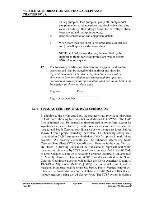
on, lag pump on, lead pump on, pump off, pump model,<br />
pump impeller, discharge pipe size, check valve size, plug<br />
valve size, design flow, design head (TDH), voltage, phase,<br />
horsepower, <strong>and</strong> rpm (pump/motor).<br />
e. Relevant construction <strong>and</strong> component details.<br />
f. When more than one sheet is required, items (a), (b), (c),<br />
<strong>and</strong> (d) shall appear on the same sheet.<br />
NOTE: CAD drawings that may be modified by the<br />
engineer to fit his particular project are available from<br />
GSWSA upon request.<br />
12. The following certification statement must appear on all as-built<br />
drawings <strong>and</strong> shall be signed by the engineer <strong>and</strong> show his<br />
registration number: I hereby certify that the sewer utilities as<br />
shown have been installed in accordance with the approved<br />
construction drawings <strong>and</strong> specifications <strong>and</strong> are, to the best of my<br />
knowledge, as shown on these plans.<br />
________________________________<br />
Engineer<br />
Date<br />
________________________________<br />
Registration Number<br />
4.1.4 FINAL AS-BUILT DIGITAL DATA SUBMISSION<br />
In addition to the mylar drawings, the engineer shall provide all drawings<br />
in CAD form showing facilities that are dedicated to GSWSA. The CAD<br />
files submitted shall be identical to those plotted in mylar form, except for<br />
signatures <strong>and</strong> seals placed by h<strong>and</strong>. <strong>Water</strong> <strong>and</strong> sewer services shall be<br />
located <strong>and</strong> South Carolina coordinate value (to the nearest foot) shall be<br />
shown. Overall project boundary (new plan, PUD, boundary survey, etc.)<br />
is required in CAD form upon submission of the first phase in multi-phase<br />
projects. All drawing elements shall be submitted referencing South<br />
Carolina State Plane (SCSP) Coordinates. Features in drawing files that<br />
are stored in drawing units must be translated to represent real world<br />
locations as referenced by SCSP coordinates. As specified in the SC Code<br />
of Laws Chapter 2, Title 27 (The South Carolina Coordinate Act, amended<br />
31 Mar89), elements referencing SCSP (formally identified as the South<br />
Carolina Coordinate System) will utilize the North American Datum of<br />
1983-1986 Adjustment (NAD83 [1986]) for horizontal control <strong>and</strong> be<br />
measured in International Feet (not US Survey Foot). Vertical control will<br />
reference the North America Vertical Datum of 1988 (NAVD88) <strong>and</strong> shall<br />
include measures using the US Survey Foot. The SCSP system includes a<br />
Service Authorization <strong>and</strong> Final Acceptance July 2009 <strong>Gr<strong>and</strong></strong> <strong>Str<strong>and</strong></strong> <strong>Water</strong> <strong>and</strong> <strong>Sewer</strong> <strong>Authority</strong><br />
Page 30<br />
Developer Policy Manual


