- Page 1 and 2: GARNER TRANSPORTATION GARNER PLAN p
- Page 3 and 4: LIST OF FIGURES AND TABLES PAGE Fig
- Page 5 and 6: to be considered in the recommendat
- Page 7 and 8: Roadways While generally in good re
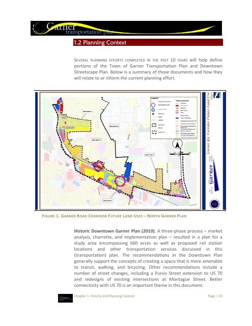
- Page 9 and 10: Chapter 1: Past Events and Plans 1.
- Page 11: Like many North Carolina locales, G
- Page 15 and 16: oadways under the authority of the
- Page 17 and 18: Transportation Plan. Article 6 prov
- Page 19 and 20: that includes unincorporated areas
- Page 21 and 22: Chapter 2: The Planning Process THE
- Page 23 and 24: • Norm Karr • Council Member Bu
- Page 25 and 26: 70 would ultimately be replaced as
- Page 27 and 28: White Oak Road Currently a two‐la
- Page 29 and 30: defined starting and ending points.
- Page 31 and 32: It is worthwhile to note that CAT a
- Page 33 and 34: the Garner Route 102 will extend to
- Page 35 and 36: Special Transit Advisory Commission
- Page 37 and 38: FIGURE 6. NCRR PASSENGER RAIL SERVI
- Page 39 and 40: TABLE 6. TRANSIT SERVICE MODE CHARA
- Page 41 and 42: families and businesses looking to
- Page 43 and 44: This page left intentionally blank.
- Page 45 and 46: walking in the central Garner area,
- Page 47 and 48: ike lanes and improve traffic flow
- Page 49 and 50: FIGURE 9. VEHICLE AND BICYCLE/PEDES
- Page 51 and 52: the age of 65 live below the nation
- Page 53 and 54: conform to existing regulations for
- Page 55 and 56: Chapter 4: Recommendations 4. 1 Cha
- Page 57 and 58: “ ‘Due to the 2007 federal ener
- Page 59 and 60: Recommendation: Conduct a conceptua
- Page 61 and 62: Automobile Performance. The bottom
- Page 63 and 64:
[This page left intentionally blank
- Page 65 and 66:
identifies a number of proposed ped
- Page 67 and 68:
On Road To Road From Road Priority
- Page 69 and 70:
Sidewalk Project Prioritization & P
- Page 71 and 72:
Facility Type Mileage Sidewalk 56.0
- Page 73 and 74:
Phase Location From To Estimated Co
- Page 75 and 76:
FIGURE 13. PROPOSED SIDEWALK PROJEC
- Page 77 and 78:
Bicycle Lane (Top) and Sharrows Sou
- Page 79 and 80:
Minimum easements for a shared‐us
- Page 81 and 82:
Crossing Improvements Crossing impr
- Page 83 and 84:
4.4 Public Transportation Services
- Page 85 and 86:
add a garbage receptacle, and add a
- Page 87 and 88:
Town of Garner may also pursue appr
- Page 89 and 90:
FIGURE 15. PUBLIC TRANSPORTATION RE
- Page 91 and 92:
Chapter 5: Implementation Guidance
- Page 93 and 94:
• Land Use Zone. Defining the nee
- Page 95 and 96:
FIGURE 17. HORIZONTAL CLEARANCE “
- Page 97 and 98:
added to the east side, including a
- Page 99 and 100:
The Street Catalog. The following p
- Page 101 and 102:
Chapter 5: Implementation Page | 99
- Page 103 and 104:
Chapter 5: Implementation Page | 10
- Page 105 and 106:
Chapter 5: Implementation Page | 10
- Page 107 and 108:
Chapter 5: Implementation Page | 10
- Page 109 and 110:
• The post‐year (i.e., after 20
- Page 111 and 112:
This leaves only two premier source
- Page 113 and 114:
TABLE 17. ROADWAY PRIORITY PROJECT
- Page 115 and 116:
5.3 Policies and Programs The Town
- Page 117 and 118:
3.3 Add an element to the I‐40 Ov
- Page 119 and 120:
streets and non‐uniform provision
- Page 121 and 122:
education campaign could be impleme
- Page 123 and 124:
TABLE 19. PEDESTRIAN AND TRANSIT CO
- Page 125 and 126:
such pamphlet has been developed by
- Page 127 and 128:
information on local resources are
- Page 129 and 130:
Appendix A: Public Engagement Proce
- Page 131 and 132:
Roadway Comments Transit Comments P
- Page 133 and 134:
Appendix B: Survey Results Summary
- Page 135 and 136:
Table 3. More Bicycling and Walking
- Page 137 and 138:
Part II. About Transportation in Ga
- Page 139 and 140:
We always have to weigh our priorit
- Page 141 and 142:
Please tell us if there are any oth
- Page 143 and 144:
Please tell us if there are any oth
- Page 145 and 146:
Please tell us if there are any oth
- Page 147 and 148:
Appendix C: Roadway Maps The follow
- Page 149 and 150:
Appendix C: Roadway Maps and Cross
- Page 151 and 152:
Appendix C: Roadway Maps and Cross
- Page 153 and 154:
Appendix C: Roadway Maps and Cross
- Page 155 and 156:
Appendix C: Roadway Maps and Cross
- Page 157 and 158:
Appendix C: Roadway Maps and Cross
- Page 159 and 160:
Appendix C: Roadway Maps and Cross
- Page 161 and 162:
Appendix D: Access Management Guide
- Page 163 and 164:
Administration: The Policy on Stree
- Page 165 and 166:
Cross‐Access - A service drive pr
- Page 167 and 168:
Traffic Impact Study - A report ini
- Page 169 and 170:
Near a signalized intersection, the
- Page 171 and 172:
Throat Length Distances: The connec
- Page 173 and 174:
edge, minimum vehicle storage of 50
- Page 175 and 176:
DRIVEWAY ACCESS REVIEW CHECKLIST Th
- Page 177 and 178:
DESIGN GUIDANCE PURPOSES The Garner
- Page 179 and 180:
COLLECTOR STREET PURPOSES To create
- Page 181 and 182:
BOULEVARD PURPOSES An important con
- Page 183 and 184:
RAIL CROSSINGS PURPOSES Rail crossi
- Page 185 and 186:
PEDESTRIAN FACILITIES PURPOSES Walk
- Page 187 and 188:
TRAFFIC CALMING PURPOSES Due to sta
- Page 189 and 190:
CONTACT NUMBERS PURPOSES The street
- Page 191 and 192:
Appendix E: Design Guidance Page |
- Page 193 and 194:
Appendix E: Design Guidance Page |