

200 - Typhoon Committee
200 - Typhoon Committee
200 - Typhoon Committee

Create successful ePaper yourself
Turn your PDF publications into a flip-book with our unique Google optimized e-Paper software.
TCAR<br />
CHAPTER 1 - TYPHOON COMMITTEE ACTIVITIES <strong>200</strong>7<br />
<strong>200</strong>7<br />
Fig. 2 Outline of aerial laser measurement<br />
In Japan, this issue is being addressed by utilizing aerial<br />
laser measurement that can capture wide-area terrain data<br />
simply with high density. With these measurements, the<br />
channel cross-section of medium- and small-size rivers<br />
is grasped, followed by calculation of flow capacity,<br />
which in turn contributes to surveys and evaluations of<br />
the flood safety of rivers.<br />
Aerial laser measurement is a technology to obtain the<br />
three-dimensional terrain data on the basis of the distance<br />
to the ground determined from the time difference<br />
between the laser irradiation from the air-borne laser<br />
scanner to the ground and the laser reflection from the<br />
ground as well as the location data of aircraft obtained<br />
with GPS locators and IMU (Inertia Measurement Unit).<br />
In turn, the three-dimensional data leads to a channel<br />
cross-section profile or topographical condition of<br />
floodplains, which makes evaluation of the flow capacity<br />
possible.<br />
To evaluate the flood safety of medium- and small-size<br />
rivers by using aerial laser measurement, measurement<br />
of about 50,000 km 2 was made in <strong>200</strong>5 on model rivers.<br />
In <strong>200</strong>6 and after, aerial laser measurement was made<br />
of about 120,000 km 2 (of 380,000 km 2 of the national<br />
land) for all Class-A rivers. As of July <strong>200</strong>7, aerial laser<br />
measurement was nearly done, and a primary evaluation<br />
of the flow capacity was completed for 72 river<br />
systems (of a total 109). Future plans include surveys,<br />
evaluations, and official announcements of flood control<br />
safety, which are scheduled for all Class-A rivers by the<br />
end of fiscal <strong>200</strong>7.<br />
2.2 Publication of “Guideline on Warning and Evacuation<br />
for Sediment-Related Disaster Prevention”<br />
It is necessary to mitigate Sediment-Related (S.R.) Disaster<br />
damage by dispensing information warning people about<br />
the degree of risk of S.R. Disasters occurring. Early<br />
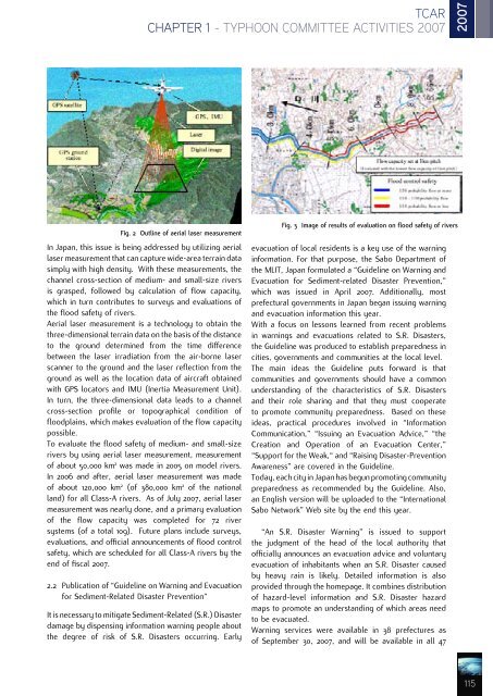
Fig. 3 Image of results of evaluation on flood safety of rivers<br />
evacuation of local residents is a key use of the warning<br />
information. For that purpose, the Sabo Department of<br />
the MLIT, Japan formulated a “Guideline on Warning and<br />
Evacuation for Sediment-related Disaster Prevention,”<br />
which was issued in April <strong>200</strong>7. Additionally, most<br />
prefectural governments in Japan began issuing warning<br />
and evacuation information this year.<br />
With a focus on lessons learned from recent problems<br />
in warnings and evacuations related to S.R. Disasters,<br />
the Guideline was produced to establish preparedness in<br />
cities, governments and communities at the local level.<br />
The main ideas the Guideline puts forward is that<br />
communities and governments should have a common<br />
understanding of the characteristics of S.R. Disasters<br />
and their role sharing and that they must cooperate<br />
to promote community preparedness. Based on these<br />
ideas, practical procedures involved in “Information<br />
Communication,” “Issuing an Evacuation Advice,” “the<br />
Creation and Operation of an Evacuation Center,”<br />
“Support for the Weak,“ and “Raising Disaster-Prevention<br />
Awareness” are covered in the Guideline.<br />
Today, each city in Japan has begun promoting community<br />
preparedness as recommended by the Guideline. Also,<br />
an English version will be uploaded to the “International<br />
Sabo Network” Web site by the end this year.<br />
“An S.R. Disaster Warning” is issued to support<br />
the judgment of the head of the local authority that<br />
officially announces an evacuation advice and voluntary<br />
evacuation of inhabitants when an S.R. Disaster caused<br />
by heavy rain is likely. Detailed information is also<br />
provided through the homepage. It combines distribution<br />
of hazard-level information and S.R. Disaster hazard<br />
maps to promote an understanding of which areas need<br />
to be evacuated.<br />
Warning services were available in 38 prefectures as<br />
of September 30, <strong>200</strong>7, and will be available in all 47<br />
115


