200 - Typhoon Committee
200 - Typhoon Committee
200 - Typhoon Committee
You also want an ePaper? Increase the reach of your titles
YUMPU automatically turns print PDFs into web optimized ePapers that Google loves.
TCAR<br />
CHAPTER 1 - TYPHOON COMMITTEE ACTIVITIES <strong>200</strong>7<br />
<strong>200</strong>7<br />
• An ensemble prediction system for typhoon tracks<br />
An ensemble prediction system was set up for typhoon<br />
track prediction based on GRAPES-TCM model. 21<br />
prediction members constituted the system. Each of<br />
the members had a horizontal resolution of 0.5 degree,<br />
in which the Breeding Method was employed for<br />
initial perturbation. In addition, vortex relocation and<br />
bogus vortex were also implemented during the quasioperational<br />
experiments. Presently, 0-72h prediction on<br />
typhoon track’s probability was made twice a day on<br />
00UTC and 12 UTC.<br />
• Evaluation on the performance of typhoon numerical<br />
model in QPF<br />
The performance of GRAPES-TCM in Quantitative<br />
Precipitation Forecast (QPF) was evaluated for cases<br />
making landfall on East China in <strong>200</strong>6. The results were<br />
also compared with those of Shanghai Regional Numerical<br />
Prediction Model and TRaP (Tropical Rainfall Potential<br />
Technique). It showed that GRAPES-TCM could represent<br />
generally well the coverage of rainfall and outperformed<br />
the other two methods, due mainly to the consistency<br />
between the vortex structure and environmental field<br />
with the updated relocation technique.<br />
• An updated model output statistical tropical cyclone<br />
intensity prediction scheme for the western North<br />
Pacific<br />
An updated model output statistical tropical cyclone<br />
intensity prediction scheme for the western North Pacific<br />
(MSTIP) was developed based on samples stronger than<br />
17.2m/s from 1996 to <strong>200</strong>2. All the samples were divided<br />
into 3 sub-groups according to the initial position: the<br />
region near the coast of East China (ECR), the South<br />
China Sea region (SCR), and the far ocean region (FOR).<br />
Regression equations were developed respectively<br />
for each region, with major predictors different for<br />
different regions. 5 versions of MSTIP were developed<br />
using different operational model output. Independent<br />
test and operational experiment in <strong>200</strong>6 showed that<br />
the version based on T213 model operating at National<br />
Meteorological Center and the one based on GFS had<br />
positive skills.<br />
• An updated consensus scheme for tropical cyclone<br />
track forecast<br />
The consensus scheme for typhoon track prediction was<br />
updated by replacing 3 statistical sub-methods with 3<br />
numerical prediction models, Shanghai <strong>Typhoon</strong> model,<br />
GRAPES-TCM, and the <strong>Typhoon</strong> model operating at<br />
National Meteorological Center. The forecast leading<br />
time was extended from 48 hour to 72 hour. Mean errors<br />
of the updated scheme for <strong>200</strong>6 were 74.8, 116.9, 158.9,<br />
208.3, 239.1, and 311km for 12, 24, 36, 48, 60, and 72 h<br />
forecast, respectively. It was put into operation in May<br />
<strong>200</strong>7.<br />
Operational system<br />
No changes in the operational system<br />
Research and development on TC track prediction<br />
1) A new vortex initialization scheme was developed<br />
and used in the new experimental TC track prediction<br />
system based on the SSI data assimilation system. The<br />
mean track errors are greatly reduced. The differences<br />
between the operational system and the new TC track<br />
prediction system are as table 1.<br />
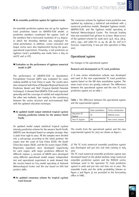
Table 1. The difference between the operational system<br />
and the experimental system<br />
Dada assimilation<br />
Vortex initialization<br />
Operation TC<br />
System<br />
OI<br />
BOGUS vortex<br />
New TC System SSI New vortex scheme<br />
The results from the operational system and the new<br />
experimental system for <strong>200</strong>7 are shown as figure 1.<br />
2) The TC track numerical ensemble prediction system<br />
was developed and put into real time running in July<br />
<strong>200</strong>7<br />
The TC track numerical ensemble prediction system was<br />
developed based on the global medium range numerical<br />
ensemble prediction system and the BOGUS vortex<br />
technique used in the operation TC track prediction<br />
system in <strong>200</strong>6 and put into real time run in <strong>200</strong>7. The<br />
ensemble tracks and the strike probability (shown as<br />
figure 2 and figure 3) are provided to the forecasting<br />
office in NMC.<br />
25


