ESCAP/WMO <strong>Typhoon</strong> <strong>Committee</strong> Annual Review <strong>200</strong>7 b. Implications for Operational Progress b.1 RSMC Data Serving System Since 25 October <strong>200</strong>5, JMA has operated a new RSMC Data Serving System (DSS) to stably provide users with higher accessibility to the Agency’s products through the Internet. WMO general file name conventions are applied in the new DSS to facilitate users’ identification of the data required. In addition to the data and products provided through the old DSS, high-density atmospheric motion vectors derived from MTSAT-1R images have been available to users through the new DSS since 2 August <strong>200</strong>6. The system provides 14 user countries/territories with the data and products shown in Tables 1 and 2 as of October <strong>200</strong>7. On 21 November <strong>200</strong>7, the system will start providing products of GSMs four times a day. Table 1 List of GPV Products on the RSMC Data Serving System Oct <strong>200</strong>7 Model GSM GSM GSM Area and resolution Levels and elements Forecast hours Whole globe, 1.25° × 1.25° 10 hPa: Z, U, V, T 20 hPa: Z, U, V, T 30 hPa: Z, U, V, T 50 hPa: Z, U, V, T 70 hPa: Z, U, V, T 100 hPa: Z, U, V, T 150 hPa: Z, U, V, T <strong>200</strong> hPa: Z, U, V, T, ψ, χ 250 hPa: Z, U, V, T 300 hPa: Z, U, V, T, H, ω 400 hPa: Z, U, V, T, H, ω 500 hPa: Z, U, V, T, H, ω, ζ 600 hPa: Z, U, V, T, H, ω 700 hPa: Z, U, V, T, H, ω 850 hPa: Z, U, V, T, H, ω, ψ, χ 925 hPa: Z, U, V, T, H, ω 1000 hPa: Z, U, V, T, H, ω Surface: P, U, V, T, H, R† 0–84 every 6 hours and 96–192 every 12 hours † Except analysis 10 hPa: Z*, U*, V*, T* 20°S–60°N, 60°E–160°W 1.25° × 1.25° Whole globe, 2.5° × 2.5° 10 hPa: Z, U, V, T 20 hPa: Z, U, V, T Surface: P , U , V , T , D , R 30 hPa: Z, U, V, T 20 hPa: Z*, U*, V*, T* 50 hPa: Z, U, V, T 30 hPa: Z°, U°, V°, T° 70 hPa: Z, U, V, T 50 hPa: Z°, U°, V°, T° 100 hPa: Z, U, V, T 70 hPa: Z°, U°, V°, T° 150 hPa: Z, U, V, T 100 hPa: Z°, U°, V°, T° <strong>200</strong> hPa: Z § , U § , V § , T § , ψ, χ 150 hPa: Z*, U*, V*, T* 250 hPa: Z, U, V, T <strong>200</strong> hPa: Z, U, V, T 300 hPa: Z, U, V, T, D 250 hPa: Z°, U°, V°, T° 400 hPa: Z, U, V, T, D 300 hPa: Z, U, V, T, D*‡ 500 hPa: Z § , U § , V § , T § , D § , ζ 400 hPa: Z*, U*, V*, T*, D*‡ 700 hPa: Z § , U § , V § , T § , D § , ω 500 hPa: Z, U, V, T, D*‡ 850 hPa: Z § , U § , V § , T § , D § , ω, 700 hPa: Z, U, V, T, D ψ, χ 850 hPa: Z, U, V, T, D 925 hPa: Z, U, V, T, D, ω 1000 hPa: Z, U*, V*, T*, D*‡ 1000 hPa: Z, U, V, T, D Surface: P, U, V, T, D‡, R† 0–84 every 6 hours § additional 96–192 every 24 hours for 12 UTC 0–192 every 6 hours Initial times 00, 06 1) ,12,18 1) UTC 00, 06 1) ,12,18 1) UTC 0–72 every 24 hours and 96–192 every 24 hours for 12 UTC ° 0–120 for 12 UTC † Except analysis * Analysis only 00 UTC and 12 UTC ‡ 00 UTC only Model GSM Mid-range EPS Area and 20°S–60°N, 80°E–<strong>200</strong>°E Whole globe, 2.5° × 2.5° resolution 2.5°× 2.5° 100 hPa: Z, U, V, T 150 hPa: Z, U, V, T 250 hPa: µU, σU, µV, σV <strong>200</strong> hPa: Z, U, V, T 500 hPa: µZ, σZ 250 hPa: Z, U, V, T Levels and 850 hPa: µU, σU, µV, σV, µT, 300 hPa: Z, U, V, T elements σT 500 hPa: Z, U, V, T, D, ζ 1000 hPa: µZ, σZ 700 hPa: Z, U, V, T, D, ω Surface: µP, σP 850 hPa: Z, U, V, T, D, ω Surface: P, U, V, T, D, R Forecast hours 0–36 every 6 hours, 48, 60 and 72 Initial times 00 UTC and 12 UTC 12 UTC 0–192 every 12 hours 32
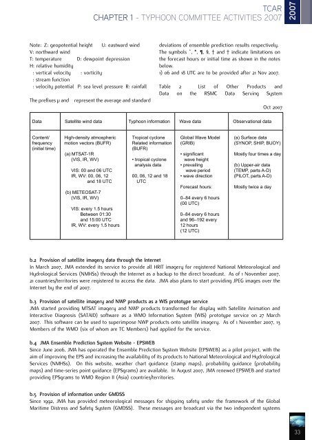
TCAR CHAPTER 1 - TYPHOON COMMITTEE ACTIVITIES <strong>200</strong>7 <strong>200</strong>7 Note: Z: geopotential height U: eastward wind V: northward wind T: temperature D: dewpoint depression H: relative humidity ω: vertical velocity (: vorticity ψ: stream function χ: velocity potential P: sea level pressure R: rainfall The prefixes µ and σ represent the average and standard deviations of ensemble prediction results respectively. The symbols °, *, , §, ‡ and † indicate limitations on the forecast hours or initial time as shown in the notes below. 1) 06 and 18 UTC are to be provided after 21 Nov <strong>200</strong>7. Table 2 List of Other Products and Data on the RSMC Data Serving System Oct <strong>200</strong>7 Data Satellite wind data <strong>Typhoon</strong> information Wave data Observational data Content/ frequency (initial time) High-density atmospheric motion vectors (BUFR) (a) MTSAT-1R (VIS, IR, WV) VIS: 00 and 06 UTC IR, WV: 00, 06, 12 and 18 UTC (b) METEOSAT-7 (VIS, IR, WV) VIS: every 1.5 hours Between 01:30 and 15:00 UTC IR, WV: every 1.5 hours Tropical cyclone Related information (BUFR) • tropical cyclone analysis data 00, 06, 12 and 18 UTC Global Wave Model (GRIB) • significant wave height • prevailing wave period • wave direction Forecast hours: 0–84 every 6 hours (00 UTC) 0–84 every 6 hours and 96–192 every 12 hours (12 UTC) (a) Surface data (SYNOP, SHIP, BUOY) Mostly four times a day (b) Upper-air data (TEMP, parts A-D) (PILOT, parts A-D) Mostly twice a day b.2 Provision of satellite imagery data through the Internet In March <strong>200</strong>7, JMA extended its service to provide all HRIT imagery for registered National Meteorological and Hydrological Services (NMHSs) through the Internet as a backup to the direct broadcast. As of 1 November <strong>200</strong>7, 21 countries/territories were registered to access the data. JMA also plans to start providing JPEG images over the Internet by the end of <strong>200</strong>7. b.3 Provision of satellite imagery and NWP products as a WIS prototype service JMA started providing MTSAT imagery and NWP products transformed for display with Satellite Animation and Interactive Diagnosis (SATAID) software as a WMO Information System (WIS) prototype service on 27 March <strong>200</strong>7. This software can be used to superimpose NWP products onto satellite imagery. As of 1 November <strong>200</strong>7, 13 Members of the WMO (six of whom are TC Members) had applied for the service. b.4 JMA Ensemble Prediction System Website - EPSWEB Since June <strong>200</strong>6, JMA has operated the Ensemble Prediction System Website (EPSWEB) as a pilot project, with the aim of improving the EPS and increasing the availability of its products to National Meteorological and Hydrological Services (NMHSs). On this website, weather chart guidance (stamp maps), probability guidance (probability maps) and time-series point guidance (EPSgrams) are available. In August <strong>200</strong>7, JMA renewed EPSWEB and started providing EPSgrams to WMO Region II (Asia) countries/territories. b.5 Provision of information under GMDSS Since 1992, JMA has provided meteorological messages for shipping safety under the framework of the Global Maritime Distress and Safety System (GMDSS). These messages are broadcast via the two independent systems 33
- Page 1 and 2: ESCAP/WMO Typhoon Committee TCAR An
- Page 3 and 4: TCAR Contents 2007 CONTENTS ESCAP,
- Page 5 and 6: TCAR Contents 2007 Appendix I Revis
- Page 7 and 8: TCAR ESCAP, WMO and the ESCAP/WMO T
- Page 9 and 10: TCAR ESCAP/WMO Typhoon Committee 20
- Page 11 and 12: TCAR ESCAP/WMO Typhoon Committee ES
- Page 13 and 14: TCAR Foreword 2007 Foreword The ESC
- Page 15 and 16: TCAR Introduction 2007 Introduction
- Page 17 and 18: TCAR CHAPTER 1 - TYPHOON COMMITTEE
- Page 19 and 20: TCAR CHAPTER 1 - TYPHOON COMMITTEE
- Page 21 and 22: TCAR CHAPTER 1 - TYPHOON COMMITTEE
- Page 23 and 24: TCAR CHAPTER 1 - TYPHOON COMMITTEE
- Page 25 and 26: TCAR CHAPTER 1 - TYPHOON COMMITTEE
- Page 27 and 28: TCAR CHAPTER 1 - TYPHOON COMMITTEE
- Page 29 and 30: TCAR CHAPTER 1 - TYPHOON COMMITTEE
- Page 31: TCAR CHAPTER 1 - TYPHOON COMMITTEE
- Page 35 and 36: TCAR CHAPTER 1 - TYPHOON COMMITTEE
- Page 37 and 38: TCAR CHAPTER 1 - TYPHOON COMMITTEE
- Page 39 and 40: TCAR CHAPTER 1 - TYPHOON COMMITTEE
- Page 41 and 42: TCAR CHAPTER 1 - TYPHOON COMMITTEE
- Page 43 and 44: TCAR CHAPTER 1 - TYPHOON COMMITTEE
- Page 45 and 46: TCAR CHAPTER 1 - TYPHOON COMMITTEE
- Page 47 and 48: TCAR CHAPTER 1 - TYPHOON COMMITTEE
- Page 49 and 50: TCAR CHAPTER 1 - TYPHOON COMMITTEE
- Page 51 and 52: TCAR CHAPTER 1 - TYPHOON COMMITTEE
- Page 53 and 54: TCAR CHAPTER 1 - TYPHOON COMMITTEE
- Page 55 and 56: TCAR CHAPTER 1 - TYPHOON COMMITTEE
- Page 57 and 58: TCAR CHAPTER 1 - TYPHOON COMMITTEE
- Page 59 and 60: TCAR CHAPTER 1 - TYPHOON COMMITTEE
- Page 61 and 62: TCAR CHAPTER 1 - TYPHOON COMMITTEE
- Page 63 and 64: TCAR CHAPTER 1 - TYPHOON COMMITTEE
- Page 65 and 66: TCAR CHAPTER 1 - TYPHOON COMMITTEE
- Page 67 and 68: TCAR CHAPTER 1 - TYPHOON COMMITTEE
- Page 69 and 70: TCAR CHAPTER 1 - TYPHOON COMMITTEE
- Page 71 and 72: TCAR CHAPTER 1 - TYPHOON COMMITTEE
- Page 73 and 74: TCAR CHAPTER 1 - TYPHOON COMMITTEE
- Page 75 and 76: TCAR CHAPTER 1 - TYPHOON COMMITTEE
- Page 77 and 78: TCAR CHAPTER 1 - TYPHOON COMMITTEE
- Page 79 and 80: TCAR CHAPTER 1 - TYPHOON COMMITTEE
- Page 81 and 82: TCAR CHAPTER 1 - TYPHOON COMMITTEE
- Page 83 and 84:
TCAR CHAPTER 1 - TYPHOON COMMITTEE
- Page 85 and 86:
TCAR CHAPTER 1 - TYPHOON COMMITTEE
- Page 87 and 88:
TCAR CHAPTER 1 - TYPHOON COMMITTEE
- Page 89 and 90:
TCAR CHAPTER 1 - TYPHOON COMMITTEE
- Page 91 and 92:
TCAR CHAPTER 1 - TYPHOON COMMITTEE
- Page 93 and 94:
TCAR CHAPTER 1 - TYPHOON COMMITTEE
- Page 95 and 96:
TCAR CHAPTER 1 - TYPHOON COMMITTEE
- Page 97 and 98:
TCAR CHAPTER 1 - TYPHOON COMMITTEE
- Page 99 and 100:
TCAR CHAPTER 1 - TYPHOON COMMITTEE
- Page 101 and 102:
TCAR CHAPTER 1 - TYPHOON COMMITTEE
- Page 103 and 104:
TCAR CHAPTER 1 - TYPHOON COMMITTEE
- Page 105 and 106:
TCAR CHAPTER 1 - TYPHOON COMMITTEE
- Page 107 and 108:
TCAR CHAPTER 1 - TYPHOON COMMITTEE
- Page 109 and 110:
TCAR CHAPTER 1 - TYPHOON COMMITTEE
- Page 111 and 112:
TCAR CHAPTER 1 - TYPHOON COMMITTEE
- Page 113 and 114:
TCAR CHAPTER 1 - TYPHOON COMMITTEE
- Page 115 and 116:
TCAR CHAPTER 1 - TYPHOON COMMITTEE
- Page 117 and 118:
TCAR CHAPTER 1 - TYPHOON COMMITTEE
- Page 119 and 120:
TCAR CHAPTER 1 - TYPHOON COMMITTEE
- Page 121 and 122:
TCAR CHAPTER 1 - TYPHOON COMMITTEE
- Page 123 and 124:
TCAR CHAPTER 1 - TYPHOON COMMITTEE
- Page 125 and 126:
TCAR CHAPTER 1 - TYPHOON COMMITTEE
- Page 127 and 128:
TCAR CHAPTER 1 - TYPHOON COMMITTEE
- Page 129 and 130:
TCAR CHAPTER 1 - TYPHOON COMMITTEE
- Page 131 and 132:
TCAR CHAPTER 1 - TYPHOON COMMITTEE
- Page 133 and 134:
TCAR CHAPTER 1 - TYPHOON COMMITTEE
- Page 135 and 136:
TCAR CHAPTER 1 - TYPHOON COMMITTEE
- Page 137 and 138:
TCAR CHAPTER 1 - TYPHOON COMMITTEE
- Page 139 and 140:
TCAR CHAPTER 1 - TYPHOON COMMITTEE
- Page 141 and 142:
TCAR CHAPTER 1 - TYPHOON COMMITTEE
- Page 143 and 144:
TCAR CHAPTER 1 - TYPHOON COMMITTEE
- Page 145 and 146:
TCAR CHAPTER 1 - TYPHOON COMMITTEE
- Page 147 and 148:
TCAR CHAPTER 1 - TYPHOON COMMITTEE
- Page 149 and 150:
TCAR CHAPTER 1 - TYPHOON COMMITTEE
- Page 151 and 152:
TCAR CHAPTER 1 - TYPHOON COMMITTEE
- Page 153 and 154:
TCAR CHAPTER 1 - TYPHOON COMMITTEE
- Page 155 and 156:
TCAR CHAPTER 1 - TYPHOON COMMITTEE
- Page 157 and 158:
TCAR CHAPTER 1 - TYPHOON COMMITTEE
- Page 159 and 160:
TCAR CHAPTER 1 - TYPHOON COMMITTEE
- Page 161 and 162:
TCAR CHAPTER 1 - TYPHOON COMMITTEE
- Page 163 and 164:
TCAR CHAPTER 1 - TYPHOON COMMITTEE
- Page 165 and 166:
TCAR CHAPTER 1 - TYPHOON COMMITTEE
- Page 167 and 168:
TCAR CHAPTER 1 - TYPHOON COMMITTEE
- Page 169 and 170:
TCAR CHAPTER 1 - TYPHOON COMMITTEE
- Page 171 and 172:
TCAR CHAPTER 1 - TYPHOON COMMITTEE
- Page 173 and 174:
TCAR CHAPTER 1 - TYPHOON COMMITTEE
- Page 175 and 176:
TCAR CHAPTER 1 - TYPHOON COMMITTEE
- Page 177 and 178:
TCAR CHAPTER 1 - TYPHOON COMMITTEE
- Page 179 and 180:
TCAR CHAPTER 1 - TYPHOON COMMITTEE
- Page 181 and 182:
TCAR CHAPTER 1 - TYPHOON COMMITTEE
- Page 183 and 184:
TCAR CHAPTER 1 - TYPHOON COMMITTEE
- Page 185 and 186:
TCAR CHAPTER 1 - TYPHOON COMMITTEE
- Page 187 and 188:
TCAR CHAPTER 1 - TYPHOON COMMITTEE
- Page 189 and 190:
TCAR CHAPTER 1 - TYPHOON COMMITTEE
- Page 191 and 192:
TCAR CHAPTER 1 - TYPHOON COMMITTEE
- Page 193 and 194:
TCAR CHAPTER 1 - TYPHOON COMMITTEE
- Page 195 and 196:
TCAR CHAPTER 1 - TYPHOON COMMITTEE
- Page 197 and 198:
TCAR CHAPTER 2 - TROPICAL CYCLONES
- Page 199 and 200:
TCAR CHAPTER 2 - TROPICAL CYCLONES
- Page 201 and 202:
TCAR CHAPTER 2 - TROPICAL CYCLONES
- Page 203 and 204:
TCAR CHAPTER 2 - TROPICAL CYCLONES
- Page 205 and 206:
TCAR CHAPTER 2 - TROPICAL CYCLONES
- Page 207 and 208:
TCAR CHAPTER 2 - TROPICAL CYCLONES
- Page 209 and 210:
TCAR CHAPTER 2 - TROPICAL CYCLONES
- Page 211 and 212:
TCAR CHAPTER 2 - TROPICAL CYCLONES
- Page 213 and 214:
TCAR CHAPTER 2 - TROPICAL CYCLONES
- Page 215 and 216:
TCAR CHAPTER 2 - TROPICAL CYCLONES
- Page 217 and 218:
TCAR CHAPTER 2 - TROPICAL CYCLONES
- Page 219 and 220:
TCAR CHAPTER 2 - TROPICAL CYCLONES
- Page 221 and 222:
TCAR CHAPTER 2 - TROPICAL CYCLONES
- Page 223 and 224:
TCAR CHAPTER 2 - TROPICAL CYCLONES
- Page 225 and 226:
TCAR CHAPTER 2 - TROPICAL CYCLONES
- Page 227 and 228:
TCAR CHAPTER 2 - TROPICAL CYCLONES
- Page 229 and 230:
TCAR CHAPTER 2 - TROPICAL CYCLONES
- Page 231 and 232:
TCAR CHAPTER 2 - TROPICAL CYCLONES
- Page 233 and 234:
TCAR CHAPTER 2 - TROPICAL CYCLONES
- Page 235 and 236:
TCAR CHAPTER 2 - TROPICAL CYCLONES
- Page 237 and 238:
TCAR CHAPTER 2 - TROPICAL CYCLONES
- Page 239 and 240:
TCAR CHAPTER 2 - TROPICAL CYCLONES
- Page 241 and 242:
TCAR CHAPTER 2 - TROPICAL CYCLONES
- Page 243 and 244:
TCAR CHAPTER 2 - TROPICAL CYCLONES
- Page 245 and 246:
TCAR CHAPTER 2 - TROPICAL CYCLONES
- Page 247 and 248:
TCAR CHAPTER 2 - TROPICAL CYCLONES
- Page 249 and 250:
TCAR CHAPTER 2 - TROPICAL CYCLONES
- Page 251 and 252:
TCAR CHAPTER 2 - TROPICAL CYCLONES
- Page 253 and 254:
TCAR CHAPTER 3 - CONTRIBUTED PAPERS
- Page 255 and 256:
TCAR CHAPTER 3 - CONTRIBUTED PAPERS
- Page 257 and 258:
TCAR CHAPTER 3 - CONTRIBUTED PAPERS
- Page 259 and 260:
TCAR CHAPTER 3 - CONTRIBUTED PAPERS
- Page 261 and 262:
TCAR CHAPTER 3 - CONTRIBUTED PAPERS
- Page 263 and 264:
TCAR CHAPTER 3 - CONTRIBUTED PAPERS
- Page 265 and 266:
TCAR CHAPTER 3 - CONTRIBUTED PAPERS
- Page 267 and 268:
TCAR CHAPTER 3 - CONTRIBUTED PAPERS
- Page 269 and 270:
TCAR CHAPTER 3 - CONTRIBUTED PAPERS
- Page 271 and 272:
TCAR CHAPTER 3 - CONTRIBUTED PAPERS
- Page 273 and 274:
TCAR CHAPTER 3 - CONTRIBUTED PAPERS
- Page 275 and 276:
TCAR CHAPTER 3 - CONTRIBUTED PAPERS
- Page 277 and 278:
TCAR CHAPTER 3 - CONTRIBUTED PAPERS
- Page 279 and 280:
TCAR CHAPTER 3 - CONTRIBUTED PAPERS
- Page 281 and 282:
TCAR CHAPTER 3 - CONTRIBUTED PAPERS
- Page 283 and 284:
TCAR CHAPTER 3 - CONTRIBUTED PAPERS
- Page 285 and 286:
TCAR CHAPTER 3 - CONTRIBUTED PAPERS
- Page 287 and 288:
TCAR CHAPTER 3 - CONTRIBUTED PAPERS
- Page 289 and 290:
TCAR CHAPTER 3 - CONTRIBUTED PAPERS
- Page 291 and 292:
TCAR CHAPTER 3 - CONTRIBUTED PAPERS
- Page 293 and 294:
TCAR CHAPTER 3 - CONTRIBUTED PAPERS
- Page 295 and 296:
TCAR CHAPTER 4 - WMO Tropical Cyclo
- Page 297 and 298:
TCAR CHAPTER 4 - WMO Tropical Cyclo
- Page 299 and 300:
TCAR CHAPTER 4 - WMO Tropical Cyclo
- Page 301 and 302:
TCAR CHAPTER 4 - WMO Tropical Cyclo
- Page 303 and 304:
TCAR APPENDIX I - TROPICAL CYCLONES
- Page 305 and 306:
TCAR APPENDIX II - CHAIRMEN OF THE
- Page 307:
TCAR APPENDIX II - CHAIRMEN OF THE