

Guidelines for the use of GNSS in surveying and mapping
Guidelines for the use of GNSS in surveying and mapping
Guidelines for the use of GNSS in surveying and mapping

Create successful ePaper yourself
Turn your PDF publications into a flip-book with our unique Google optimized e-Paper software.
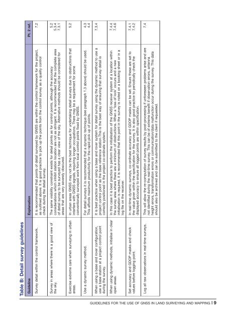
Table B: Detail survey guidel<strong>in</strong>es<br />
Guidel<strong>in</strong>e Explanation Pt. 2 ref.<br />
Survey detail with<strong>in</strong> <strong>the</strong> control framework. It is recommended that po<strong>in</strong>ts <strong>of</strong> detail surveyed by <strong>GNSS</strong> are with<strong>in</strong> <strong>the</strong> control framework <strong>for</strong> <strong>the</strong> project,<br />
as outl<strong>in</strong>ed above. It is good practice to pick up <strong>the</strong> po<strong>in</strong>ts from <strong>the</strong> control survey as a quality control<br />
check dur<strong>in</strong>g <strong>the</strong> detail survey.<br />
7.2<br />
Survey <strong>in</strong> areas where <strong>the</strong>re is a good view <strong>of</strong><br />
<strong>the</strong> sky.<br />
The same visibility constra<strong>in</strong>t exists <strong>for</strong> detail po<strong>in</strong>ts as <strong>for</strong> control po<strong>in</strong>ts, although <strong>the</strong> accuracy<br />
considerations which <strong>in</strong>hibit station location are not as str<strong>in</strong>gent. It is recommended that <strong>the</strong> complete area<br />
<strong>of</strong> detail survey to be surveyed has a clear view <strong>of</strong> <strong>the</strong> sky. Alternative methods should be considered <strong>for</strong><br />
areas that are very severely obscured.<br />
5.2<br />
5.3.4<br />
7.3.1<br />
Exercise extreme care when survey<strong>in</strong>g <strong>in</strong> urban<br />
areas.<br />
In urban areas <strong>GNSS</strong> may not be <strong>the</strong> best technique <strong>for</strong> undertak<strong>in</strong>g detail surveys due to obstructions that<br />
<strong>in</strong>terfere with <strong>GNSS</strong> signals, requir<strong>in</strong>g longer occupations. There may be a requirement <strong>for</strong> some<br />
conventionally surveyed work from local control po<strong>in</strong>ts fixed by <strong>GNSS</strong>.<br />
5.2<br />
Use a dynamic survey method. For detail surveys it is recommended that a dynamic technique (see paragraph 1.3 above) should be <strong>use</strong>d.<br />
This af<strong>for</strong>ds maximum productivity <strong>for</strong> <strong>the</strong> rapid pick up <strong>of</strong> po<strong>in</strong>ts.<br />
4.3<br />
4.4<br />
When us<strong>in</strong>g a base <strong>and</strong> rover configuration,<br />
<strong>use</strong> a base station at a project control po<strong>in</strong>t<br />
dur<strong>in</strong>g <strong>the</strong> survey.<br />
It is best practice when us<strong>in</strong>g a base <strong>and</strong> rover system <strong>for</strong> detail survey us<strong>in</strong>g <strong>the</strong> dynamic method to <strong>use</strong> a<br />
project control po<strong>in</strong>t as <strong>the</strong> base reference station.This is <strong>the</strong> best way <strong>of</strong> ensur<strong>in</strong>g that survey detail is<br />
correctly positioned <strong>in</strong> <strong>the</strong> project co-ord<strong>in</strong>ate system.<br />
7.3.4<br />
When us<strong>in</strong>g dynamic methods, <strong>in</strong>itialise <strong>in</strong> clear<br />
open areas.<br />
In this case it is best practice to per<strong>for</strong>m <strong>the</strong> <strong>in</strong>itialisation <strong>of</strong> <strong>the</strong> <strong>GNSS</strong> receiver system at a location with<strong>in</strong><br />
<strong>the</strong> survey area where <strong>the</strong>re are a m<strong>in</strong>imum <strong>of</strong> obstructions. When a ‘loss <strong>of</strong> lock’ occurs <strong>and</strong> a new<br />
<strong>in</strong>itialisation is required, it is recommended that this po<strong>in</strong>t <strong>in</strong> <strong>the</strong> survey is noted on a book<strong>in</strong>g sheet or <strong>in</strong> a<br />
log file on <strong>the</strong> receiver.<br />
7.4.4<br />
7.4.6<br />
Set accuracy <strong>and</strong> GDOP masks <strong>and</strong> check<br />
values be<strong>for</strong>e logg<strong>in</strong>g po<strong>in</strong>t.<br />
In real-time dynamic surveys, co-ord<strong>in</strong>ate accuracy <strong>and</strong> GDOP masks can be set. Ensure <strong>the</strong>se are set to<br />
<strong>the</strong> value given with<strong>in</strong> <strong>the</strong> specification <strong>for</strong> <strong>the</strong> survey. It is also good practice to periodically check <strong>the</strong><br />
displayed accuracy to ensure all logged po<strong>in</strong>ts are with<strong>in</strong> specification.<br />
7.4.1<br />
7.4.2<br />
Log all raw observations <strong>in</strong> real-time surveys. This will allow <strong>the</strong> re-computation <strong>of</strong> survey results by post-process<strong>in</strong>g if un<strong>for</strong>eseen problems arise <strong>and</strong> are<br />
not identified dur<strong>in</strong>g <strong>the</strong> real-time survey. This can be <strong>of</strong> extreme benefit if observation errors, antenna<br />
height errors, trans<strong>for</strong>mation errors or communication/data malfunction occur dur<strong>in</strong>g <strong>the</strong> survey. This data<br />
should also be archived <strong>and</strong> can be submitted to <strong>the</strong> client if requested.<br />
7.4<br />
GUIDELINES FOR THE USE OF <strong>GNSS</strong> IN LAND SURVEYING AND MAPPING |9


