

Guidelines for the use of GNSS in surveying and mapping
Guidelines for the use of GNSS in surveying and mapping
Guidelines for the use of GNSS in surveying and mapping

You also want an ePaper? Increase the reach of your titles
YUMPU automatically turns print PDFs into web optimized ePapers that Google loves.
In addition, phase centre variations (section 5.3.3)<br />
may not be <strong>in</strong>cluded <strong>in</strong> <strong>the</strong> s<strong>of</strong>tware models. In<br />
real-time surveys, <strong>the</strong> manufacturers <strong>of</strong>ten <strong>use</strong> a<br />
bespoke data <strong>for</strong>mat <strong>for</strong> <strong>the</strong> transmission between<br />
base <strong>and</strong> rover. Thus, it is extremely unlikely that a<br />
rover unit from one manufacturer will work with <strong>the</strong><br />
base station from ano<strong>the</strong>r. Even if such an<br />
arrangement is claimed to work by <strong>the</strong><br />
manufacturer, it is not recommended as best<br />
practice.<br />
Apart from <strong>the</strong> above two reasons it may simply be<br />
found on completion <strong>of</strong> <strong>the</strong> fieldwork that data from<br />
one manufacturer’s receiver will not load correctly<br />
<strong>in</strong>to process<strong>in</strong>g s<strong>of</strong>tware from ano<strong>the</strong>r<br />
manufacturer. Data may subsequently be available<br />
<strong>in</strong> RINEX <strong>for</strong>mat, but manufacturer-specific<br />
<strong>in</strong><strong>for</strong>mation can be lost <strong>in</strong> conversion to this <strong>for</strong>mat.<br />
Advanced process<strong>in</strong>g techniques may be needed<br />
<strong>for</strong> RINEX datasets, as specialist knowledge can be<br />
needed to reduce <strong>the</strong> possibilities <strong>for</strong> error.<br />
5.3.3 Antenna phase centre variations<br />
Until <strong>the</strong> late 1990s, antenna phase centre<br />
variations were not modelled as part <strong>of</strong> <strong>the</strong> <strong>GNSS</strong><br />
process<strong>in</strong>g techniques. Such variations <strong>of</strong> <strong>the</strong><br />
electrical phase centre <strong>of</strong> a <strong>GNSS</strong> antenna are a<br />
function <strong>of</strong> <strong>the</strong> elevation <strong>and</strong> azimuth angle<br />
between <strong>the</strong> receiver/antenna <strong>and</strong> a satellite. These<br />
variations are particularly evident <strong>in</strong> <strong>the</strong> vertical<br />
direction <strong>and</strong> differ <strong>in</strong> amplitude <strong>and</strong> phase <strong>for</strong><br />
different types <strong>of</strong> <strong>GNSS</strong> antenna. If <strong>the</strong> same type<br />
<strong>of</strong> antenna is <strong>use</strong>d on a relatively short basel<strong>in</strong>e,<br />
<strong>the</strong> antennas’ phase centre variations will be<br />
cancelled out beca<strong>use</strong> both antennas have<br />
practically <strong>the</strong> same elevation angle to a particular<br />
satellite. However, as basel<strong>in</strong>e length <strong>in</strong>creases, <strong>the</strong><br />
elevation angles to a satellite from both ends <strong>of</strong> a<br />
basel<strong>in</strong>e differ <strong>and</strong> <strong>the</strong> antenna phase centre<br />
variations become more significant. Fur<strong>the</strong>rmore, if<br />
different <strong>GNSS</strong> receiver/antenna types are be<strong>in</strong>g<br />
<strong>use</strong>d, <strong>the</strong>n <strong>the</strong> different antenna phase centre<br />
variations will certa<strong>in</strong>ly not be cancelled.<br />
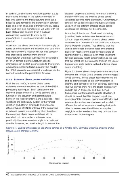
In studies, Schupler <strong>and</strong> Clark <strong>use</strong>d laboratory<br />
(chamber) tests to determ<strong>in</strong>e <strong>the</strong> elevation <strong>and</strong><br />
azimuth angle dependent antenna phase centre<br />
variations <strong>for</strong> a Trimble 4000 SST/SSE <strong>and</strong> a Rogue<br />
Dorne-Margol<strong>in</strong> antenna. They showed that <strong>the</strong><br />
vertical differences between <strong>the</strong>se two antenna<br />
types can reach 35mm at an elevation angle <strong>of</strong><br />
approximately 55 degrees. Even more important,<br />
<strong>for</strong> high accuracy height determ<strong>in</strong>ation, is <strong>the</strong> fact<br />
that this effect can be worsened through <strong>the</strong> <strong>use</strong> <strong>of</strong><br />
tropospheric scale factors, without antenna phase<br />
centre modell<strong>in</strong>g.<br />
Figure 5.1 below shows <strong>the</strong> phase centre variations<br />
between <strong>the</strong> Trimble <strong>GNSS</strong> antenna <strong>and</strong> <strong>the</strong> Rogue<br />
<strong>GNSS</strong> antenna. These biases feed directly <strong>in</strong>to <strong>the</strong><br />
end co-ord<strong>in</strong>ates <strong>and</strong> so are very important to<br />
quantify <strong>and</strong> correct <strong>for</strong> <strong>in</strong> high-accuracy survey<strong>in</strong>g.<br />
The two curves show how <strong>the</strong> phase centres vary<br />
on both <strong>the</strong> L1 frequency <strong>and</strong> dual (L1/L2)<br />
frequencies, plotted aga<strong>in</strong>st satellite elevation. It<br />
should be noted that this diagram is just one<br />
example <strong>of</strong> this particular operational difficulty, <strong>and</strong><br />
antennas from o<strong>the</strong>r manufacturers will exhibit<br />
different behaviour when compared aga<strong>in</strong>st each<br />
o<strong>the</strong>r. In some cases <strong>the</strong> differences may be<br />
negligible, whilst <strong>in</strong> o<strong>the</strong>rs <strong>the</strong>y may be more than<br />
those shown <strong>in</strong> <strong>the</strong> diagram.<br />
Figure 5.1: Vertical differences <strong>in</strong> <strong>the</strong> phase centres <strong>of</strong> a Trimble 4000 SST/SSE Geodetic antenna <strong>and</strong> a<br />
Rogue Dorne-Margol<strong>in</strong> antenna<br />
40 | GUIDELINES FOR THE USE OF <strong>GNSS</strong> IN LAND SURVEYING AND MAPPING


