Guidelines for the use of GNSS in surveying and mapping
Guidelines for the use of GNSS in surveying and mapping
Guidelines for the use of GNSS in surveying and mapping
Create successful ePaper yourself
Turn your PDF publications into a flip-book with our unique Google optimized e-Paper software.
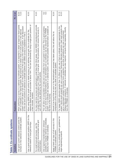
Table I: Co-ord<strong>in</strong>ate systems<br />
Guidel<strong>in</strong>e Explanation Pt. 2 ref.<br />
Use good current national control po<strong>in</strong>ts <strong>for</strong><br />
surveys on <strong>the</strong> national co-ord<strong>in</strong>ate system.<br />
When per<strong>for</strong>m<strong>in</strong>g a survey <strong>in</strong> a national co-ord<strong>in</strong>ate system, it is essential to obta<strong>in</strong> at least two fixed po<strong>in</strong>ts<br />
with co-ord<strong>in</strong>ates <strong>in</strong> <strong>the</strong> national system. Best practice is to obta<strong>in</strong> three or more po<strong>in</strong>ts <strong>in</strong> <strong>the</strong> national<br />
system which will allow a full check on <strong>the</strong> accuracy <strong>of</strong> <strong>the</strong> survey <strong>in</strong> <strong>the</strong> national system. A full discussion<br />
on <strong>the</strong> <strong>use</strong> <strong>and</strong> concerns <strong>of</strong> national co-ord<strong>in</strong>ate systems with <strong>GNSS</strong> surveys is expla<strong>in</strong>ed <strong>in</strong> Part 2.<br />
6.3.5<br />
7.2.3<br />
Use a good s<strong>in</strong>gle po<strong>in</strong>t position (SPP) <strong>for</strong> <strong>the</strong><br />
reference station <strong>in</strong> local grid surveys.<br />
When us<strong>in</strong>g <strong>GNSS</strong> <strong>for</strong> small control or detail surveys on an arbitrary local grid, <strong>the</strong> co-ord<strong>in</strong>ate <strong>for</strong> <strong>the</strong><br />
reference station should be accurate to about 10m. This can be achieved by us<strong>in</strong>g a s<strong>in</strong>gle po<strong>in</strong>t position <strong>of</strong><br />
a few m<strong>in</strong>utes’ duration.<br />
6.3.5<br />
For small local grid surveys, <strong>use</strong> <strong>the</strong><br />
manufacturer’s recommended local grid<br />
trans<strong>for</strong>mation.<br />
As many real-time surveys are per<strong>for</strong>med <strong>in</strong> small (less than 2km) areas, most <strong>GNSS</strong> manufacturers provide<br />
a simple best-fit trans<strong>for</strong>mation from ITRS89 to a local grid. Use this procedure, but ensure <strong>the</strong> survey is<br />
well with<strong>in</strong> <strong>the</strong> area def<strong>in</strong>ed by <strong>the</strong> control po<strong>in</strong>ts.<br />
6.3.5<br />
Use a rigorous trans<strong>for</strong>mation wherever<br />
possible to compute national co-ord<strong>in</strong>ates<br />
directly from ITRS89 co-ord<strong>in</strong>ates.<br />
This will allow re-computation <strong>of</strong> data <strong>and</strong> co-ord<strong>in</strong>ates from one system to ano<strong>the</strong>r. This is good practice,<br />
as any errors due to trans<strong>for</strong>mations can be elim<strong>in</strong>ated <strong>and</strong> co-ord<strong>in</strong>ates can be returned to <strong>the</strong> ITRS89<br />
system. If co-ord<strong>in</strong>ates are required <strong>in</strong> a national system, <strong>use</strong> <strong>the</strong> best possible trans<strong>for</strong>mation available at<br />
<strong>the</strong> time <strong>of</strong> <strong>the</strong> survey.<br />
6.2<br />
6.3<br />
Keep a back-up copy <strong>of</strong> all surveys <strong>in</strong> <strong>the</strong><br />
ITRS89 co-ord<strong>in</strong>ate system.<br />
Should it be found that an error <strong>in</strong> <strong>the</strong> trans<strong>for</strong>mation process has taken place, this will allow <strong>the</strong> recomputation<br />
<strong>of</strong> <strong>the</strong> survey <strong>in</strong>to any o<strong>the</strong>r co-ord<strong>in</strong>ate system.<br />
6.3.5<br />
Follow <strong>the</strong> co-ord<strong>in</strong>ate system guidel<strong>in</strong>es <strong>for</strong><br />
large eng<strong>in</strong>eer<strong>in</strong>g projects.<br />
For larger <strong>GNSS</strong> networks (greater than 15–20km or so), <strong>use</strong> a f<strong>in</strong>al co-ord<strong>in</strong>ate system appropriate to <strong>the</strong><br />
project. North–south projects can <strong>use</strong> a customised Transverse Mercator projection. East–west projects can<br />
<strong>use</strong> a customised Lambert Con<strong>for</strong>mal Conic projection, <strong>and</strong> o<strong>the</strong>r orientations can <strong>use</strong> a customised<br />
Oblique Mercator projection. If national co-ord<strong>in</strong>ates are also required, compute <strong>the</strong>se separately, directly<br />
from <strong>the</strong> ITRS89 co-ord<strong>in</strong>ates.<br />
6.1.5<br />
6.3.3<br />
GUIDELINES FOR THE USE OF <strong>GNSS</strong> IN LAND SURVEYING AND MAPPING |21


