

Guidelines for the use of GNSS in surveying and mapping
Guidelines for the use of GNSS in surveying and mapping
Guidelines for the use of GNSS in surveying and mapping

You also want an ePaper? Increase the reach of your titles
YUMPU automatically turns print PDFs into web optimized ePapers that Google loves.
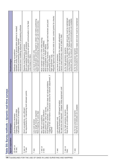
Table D3: Survey methods – dynamic real-time surveys<br />
Epoch separation Advantages Disadvantages<br />
20 sec or<br />
30 sec<br />
Dual-frequency receivers<br />
Forgiv<strong>in</strong>g, tolerates cycle slips<br />
Calculates effects <strong>of</strong> ionosphere<br />
Relatively long occupations<br />
Geodetic choke r<strong>in</strong>g or ground-plane antenna is needed<br />
Advanced process<strong>in</strong>g strategies required<br />
Advanced error modell<strong>in</strong>g required <strong>in</strong> process<strong>in</strong>g s<strong>of</strong>tware<br />
5 sec or<br />
10 sec<br />
Short occupations, very efficient<br />
No requirements <strong>for</strong> ma<strong>in</strong>ta<strong>in</strong><strong>in</strong>g lock between po<strong>in</strong>ts<br />
Requires dual-frequency receivers<br />
More susceptible to GDOP problems<br />
Requires careful plann<strong>in</strong>g <strong>and</strong> good communication <strong>in</strong> <strong>the</strong> field<br />
L<strong>in</strong>es limited to 40km<br />
1 sec Low-cost receiver<br />
Only s<strong>in</strong>gle receiver required<br />
More <strong>for</strong>giv<strong>in</strong>g <strong>of</strong> cycle slips<br />
Low level <strong>of</strong> precision only<br />
Long observation period required to obta<strong>in</strong> sub-metre position<strong>in</strong>g<br />
Need specialist process<strong>in</strong>g s<strong>of</strong>tware to get sub-metre accuracy<br />
1 sec or<br />
2 sec<br />
Very short occupations<br />
Most effective data collection<br />
One person can carry out survey<br />
Dual-frequency receivers – loss <strong>of</strong> lock does not ca<strong>use</strong> problems<br />
Logg<strong>in</strong>g <strong>of</strong> QC <strong>in</strong><strong>for</strong>mation to produce vectors <strong>for</strong> network adjustment, if<br />
required<br />
Must ma<strong>in</strong>ta<strong>in</strong> lock to 4 SVs while mov<strong>in</strong>g<br />
Must <strong>in</strong>itialise with 5 or more satellites<br />
Most susceptible to PDOP effects<br />
Dual-frequency receivers – requires high-end receivers <strong>and</strong> postprocess<strong>in</strong>g<br />
s<strong>of</strong>tware<br />
High equipment cost<br />
Requires rigorous QC <strong>and</strong> re-visits to static control po<strong>in</strong>ts <strong>for</strong> checks<br />
1 sec Low equipment cost<br />
Effective technique <strong>for</strong> GIS/asset location<br />
No real-time l<strong>in</strong>k required – cheaper <strong>in</strong>itial equipment cost<br />
Low level <strong>of</strong> precision<br />
Vectors not appropriate <strong>for</strong> network adjustment<br />
Cannot check accuracy values <strong>of</strong> data <strong>in</strong> field<br />
1 sec or<br />
2sec<br />
As <strong>for</strong> high-precision dynamic<br />
Real-time co-ord<strong>in</strong>ates are available<br />
As <strong>for</strong> high-precision dynamic<br />
Communications l<strong>in</strong>k between base <strong>and</strong> rover must be ma<strong>in</strong>ta<strong>in</strong>ed<br />
L<strong>in</strong>es limited to 15–20km. For Network RTK <strong>the</strong> service operates<br />
anywhere with<strong>in</strong> <strong>the</strong> network where communications are available.<br />
1 sec As <strong>for</strong> low-precision dynamic<br />
Real-time co-ord<strong>in</strong>ates are available<br />
As <strong>for</strong> low-precision dynamic<br />
Communications l<strong>in</strong>k between base <strong>and</strong> rover must be ma<strong>in</strong>ta<strong>in</strong>ed<br />
14 | GUIDELINES FOR THE USE OF <strong>GNSS</strong> IN LAND SURVEYING AND MAPPING


