

Guidelines for the use of GNSS in surveying and mapping
Guidelines for the use of GNSS in surveying and mapping
Guidelines for the use of GNSS in surveying and mapping

Create successful ePaper yourself
Turn your PDF publications into a flip-book with our unique Google optimized e-Paper software.
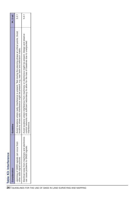
Table K3: Interference<br />
Consideration Guidel<strong>in</strong>e Pt. 2 ref.<br />
Jamm<strong>in</strong>g <strong>of</strong> <strong>GNSS</strong> signals can occur from<br />
o<strong>the</strong>r radio signal sources.<br />
Avoid locations where radio <strong>in</strong>terference is present. Test dur<strong>in</strong>g <strong>the</strong> plann<strong>in</strong>g phase at critical po<strong>in</strong>ts. Avoid<br />
locations where radio <strong>in</strong>terference might be present, e.g. near radio <strong>and</strong> television masts.<br />
5.3.1<br />
Electrical noise from mach<strong>in</strong>ery <strong>and</strong> electronics<br />
can ca<strong>use</strong> problems to <strong>GNSS</strong> signals.<br />
Avoid locations where <strong>in</strong>terference from mach<strong>in</strong>ery or electronics might be present. Design <strong>and</strong> observe<br />
control networks with sufficient redundancy to allow <strong>for</strong> <strong>the</strong> loss <strong>of</strong> basel<strong>in</strong>es due to unexpected<br />
<strong>in</strong>terference.<br />
5.3.1<br />
26 | GUIDELINES FOR THE USE OF <strong>GNSS</strong> IN LAND SURVEYING AND MAPPING


