

Guidelines for the use of GNSS in surveying and mapping
Guidelines for the use of GNSS in surveying and mapping
Guidelines for the use of GNSS in surveying and mapping

You also want an ePaper? Increase the reach of your titles
YUMPU automatically turns print PDFs into web optimized ePapers that Google loves.
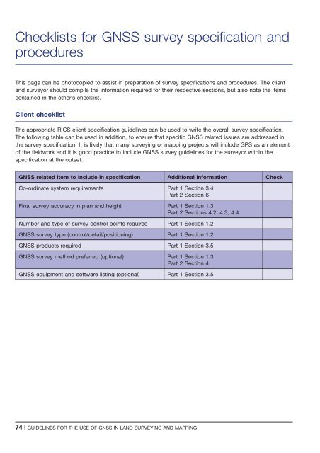
Checklists <strong>for</strong> <strong>GNSS</strong> survey specification <strong>and</strong><br />
procedures<br />
This page can be photocopied to assist <strong>in</strong> preparation <strong>of</strong> survey specifications <strong>and</strong> procedures. The client<br />
<strong>and</strong> surveyor should compile <strong>the</strong> <strong>in</strong><strong>for</strong>mation required <strong>for</strong> <strong>the</strong>ir respective sections, but also note <strong>the</strong> items<br />
conta<strong>in</strong>ed <strong>in</strong> <strong>the</strong> o<strong>the</strong>r’s checklist.<br />
Client checklist<br />
The appropriate RICS client specification guidel<strong>in</strong>es can be <strong>use</strong>d to write <strong>the</strong> overall survey specification.<br />
The follow<strong>in</strong>g table can be <strong>use</strong>d <strong>in</strong> addition, to ensure that specific <strong>GNSS</strong> related issues are addressed <strong>in</strong><br />
<strong>the</strong> survey specification. It is likely that many survey<strong>in</strong>g or mapp<strong>in</strong>g projects will <strong>in</strong>clude GPS as an element<br />
<strong>of</strong> <strong>the</strong> fieldwork <strong>and</strong> it is good practice to <strong>in</strong>clude <strong>GNSS</strong> survey guidel<strong>in</strong>es <strong>for</strong> <strong>the</strong> surveyor with<strong>in</strong> <strong>the</strong><br />
specification at <strong>the</strong> outset.<br />
<strong>GNSS</strong> related item to <strong>in</strong>clude <strong>in</strong> specification Additional <strong>in</strong><strong>for</strong>mation Check<br />
Co-ord<strong>in</strong>ate system requirements Part 1 Section 3.4<br />
Part 2 Section 6<br />
F<strong>in</strong>al survey accuracy <strong>in</strong> plan <strong>and</strong> height Part 1 Section 1.3<br />
Part 2 Sections 4.2, 4.3, 4.4<br />
Number <strong>and</strong> type <strong>of</strong> survey control po<strong>in</strong>ts required Part 1 Section 1.2<br />
<strong>GNSS</strong> survey type (control/detail/position<strong>in</strong>g) Part 1 Section 1.2<br />
<strong>GNSS</strong> products required Part 1 Section 3.5<br />
<strong>GNSS</strong> survey method preferred (optional) Part 1 Section 1.3<br />
Part 2 Section 4<br />
<strong>GNSS</strong> equipment <strong>and</strong> s<strong>of</strong>tware list<strong>in</strong>g (optional) Part 1 Section 3.5<br />
74 | GUIDELINES FOR THE USE OF <strong>GNSS</strong> IN LAND SURVEYING AND MAPPING


