

Guidelines for the use of GNSS in surveying and mapping
Guidelines for the use of GNSS in surveying and mapping
Guidelines for the use of GNSS in surveying and mapping

Create successful ePaper yourself
Turn your PDF publications into a flip-book with our unique Google optimized e-Paper software.
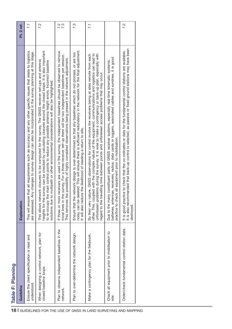
Table F: Plann<strong>in</strong>g<br />
Guidel<strong>in</strong>e Explanation Pt. 2 ref.<br />
Ensure <strong>the</strong> client specification is read <strong>and</strong><br />
understood.<br />
This will ensure that all requirements such as accuracy <strong>and</strong> any o<strong>the</strong>r specific issues that relate to logistics<br />
are assessed. Any changes to survey design can also be <strong>in</strong>corporated <strong>in</strong> <strong>the</strong> survey plann<strong>in</strong>g at this stage.<br />
7.1<br />
When design<strong>in</strong>g a control network, plan <strong>for</strong><br />
closed basel<strong>in</strong>e loops.<br />
This allows network closures to be computed <strong>for</strong> <strong>the</strong> survey. The <strong>GNSS</strong> receiver set-ups <strong>and</strong> antenna<br />
heights <strong>for</strong> <strong>the</strong> survey can be checked by calculat<strong>in</strong>g closures around <strong>the</strong> closed loops. It is also important<br />
to re-occupy <strong>the</strong> ma<strong>in</strong> control po<strong>in</strong>ts to reduce any possible antenna height errors. Incorrect basel<strong>in</strong>e<br />
solutions due to multipath or o<strong>the</strong>r environmental considerations will also be highlighted.<br />
7.2<br />
Plan to observe <strong>in</strong>dependent basel<strong>in</strong>es <strong>in</strong> <strong>the</strong><br />
network.<br />
If three or more receivers are <strong>use</strong>d <strong>in</strong> <strong>the</strong> survey, <strong>the</strong> <strong>in</strong>dependent basel<strong>in</strong>es should be observed to remove<br />
trivial l<strong>in</strong>es <strong>in</strong> <strong>the</strong> survey. For a three-receiver set-up <strong>the</strong>re will be two <strong>in</strong>dependent basel<strong>in</strong>es per session.<br />
This removes <strong>the</strong> possibility <strong>of</strong> highly correlated observations be<strong>in</strong>g present <strong>in</strong> <strong>the</strong> network adjustment.<br />
7.2<br />
7.3<br />
Plan to over-determ<strong>in</strong>e <strong>the</strong> network design. Ensure that <strong>the</strong> network design is over-determ<strong>in</strong>ed so that any basel<strong>in</strong>es which do not process, or are too<br />
noisy, can be deleted. This will ensure <strong>the</strong>re is sufficient redundancy <strong>in</strong> <strong>the</strong> network <strong>for</strong> <strong>the</strong> f<strong>in</strong>al adjustment.<br />
It will also reduce <strong>the</strong> likelihood <strong>of</strong> need<strong>in</strong>g a return to site.<br />
7.3<br />
Make a cont<strong>in</strong>gency plan <strong>for</strong> <strong>the</strong> fieldwork. By <strong>the</strong>ir very nature, <strong>GNSS</strong> observations <strong>for</strong> control <strong>in</strong>volve <strong>the</strong> receivers be<strong>in</strong>g at sites remote from each<br />
o<strong>the</strong>r. This, coupled with <strong>the</strong> complex nature <strong>of</strong> <strong>the</strong> equipment, communications <strong>and</strong> logistics can lead to<br />
un<strong>for</strong>eseen problems dur<strong>in</strong>g <strong>the</strong> survey. It is wise to make a cont<strong>in</strong>gency or back-up plan, especially with<br />
regard to <strong>the</strong> travell<strong>in</strong>g time between po<strong>in</strong>ts <strong>and</strong> un<strong>for</strong>eseen access problems that may occur.<br />
7.1<br />
Check all equipment prior to mobilisation to<br />
site.<br />
Due to <strong>the</strong> many constituent parts <strong>of</strong> <strong>GNSS</strong> receiver systems, especially real-time k<strong>in</strong>ematic systems:<br />
batteries, antennas, receivers, radios, data cards or loggers, associated cables <strong>and</strong> sundries, it is good<br />
practice to check all equipment prior to mobilisation.<br />
Order/check fundamental control station data. It is good practice to check that <strong>the</strong> co-ord<strong>in</strong>ates or data <strong>for</strong> <strong>the</strong> fundamental control stations are available.<br />
It is also recommended that back-up control is selected, as passive or fixed ground stations may have been<br />
destroyed.<br />
7.2<br />
18 | GUIDELINES FOR THE USE OF <strong>GNSS</strong> IN LAND SURVEYING AND MAPPING


