

Guidelines for the use of GNSS in surveying and mapping
Guidelines for the use of GNSS in surveying and mapping
Guidelines for the use of GNSS in surveying and mapping

Create successful ePaper yourself
Turn your PDF publications into a flip-book with our unique Google optimized e-Paper software.
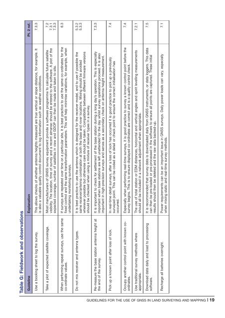
Table G: Fieldwork <strong>and</strong> observations<br />
Guidel<strong>in</strong>e Explanation Pt. 2 ref.<br />
Use a book<strong>in</strong>g sheet to log <strong>the</strong> survey. This allows checks <strong>of</strong> whe<strong>the</strong>r antenna heights measured are true vertical or slope distance, <strong>for</strong> example. It<br />
is also a valuable quality control document to log <strong>in</strong><strong>for</strong>mation such as wea<strong>the</strong>r conditions.<br />
7.3.3<br />
Take a plot <strong>of</strong> expected satellite coverage. Most manufacturers <strong>of</strong> <strong>GNSS</strong> survey equipment provide a s<strong>of</strong>tware programme to calculate future satellite<br />
visibility. The location, time <strong>of</strong> survey <strong>and</strong> a recent almanac should be entered to <strong>the</strong> s<strong>of</strong>tware. A plot <strong>of</strong> <strong>the</strong><br />
expected coverage, number <strong>of</strong> satellites <strong>in</strong> view <strong>and</strong> GDOP can <strong>the</strong>n be made <strong>and</strong> taken to site.<br />
7.2<br />
7.3.1<br />
7.3.3<br />
When per<strong>for</strong>m<strong>in</strong>g repeat surveys, <strong>use</strong> <strong>the</strong> same<br />
co-ord<strong>in</strong>ate values.<br />
If surveys are repeated over time on a particular site, it is best practice to <strong>use</strong> <strong>the</strong> same co-ord<strong>in</strong>ates <strong>for</strong> <strong>the</strong><br />
fixed control <strong>and</strong> <strong>the</strong> same trans<strong>for</strong>mation parameters. This will help m<strong>in</strong>imise variations, <strong>for</strong> example, when<br />
undertak<strong>in</strong>g monitor<strong>in</strong>g surveys.<br />
6.3<br />
Do not mix receiver <strong>and</strong> antenna types. It is best practice to <strong>use</strong> <strong>the</strong> antenna which is designed <strong>for</strong> <strong>the</strong> receiver model, <strong>and</strong> to <strong>use</strong> if possible <strong>the</strong><br />
same receiver/antenna comb<strong>in</strong>ation at both <strong>the</strong> base <strong>and</strong> rover locations. Mix<strong>in</strong>g should be avoided<br />
whenever possible but o<strong>the</strong>rwise care should be taken. Compatibility between different firmware versions<br />
should be checked when us<strong>in</strong>g a mixture <strong>of</strong> receiver types <strong>in</strong> a survey.<br />
5.3.2<br />
5.3.3<br />
Re-measure <strong>the</strong> base station antenna height at<br />
<strong>the</strong> end <strong>of</strong> <strong>the</strong> survey.<br />
It is important to check <strong>for</strong> settlement <strong>of</strong> <strong>the</strong> base station dur<strong>in</strong>g a long day’s operation. This is especially<br />
important when base stations are left unattended <strong>for</strong> <strong>the</strong> day whilst survey operations proceed. It is also<br />
important <strong>in</strong> high-precision surveys <strong>and</strong> serves as a secondary check on antenna height measurement.<br />
7.3.3<br />
Pick up a known po<strong>in</strong>t after loss <strong>of</strong> lock. In real-time detail surveys, after a loss <strong>of</strong> lock has occurred it is good practice to pick up a previously<br />
surveyed po<strong>in</strong>t. This can be coded as a detail or check po<strong>in</strong>t to ensure <strong>the</strong> correct <strong>in</strong>itialisation has<br />
occurred.<br />
7.4<br />
Occupy ano<strong>the</strong>r control po<strong>in</strong>t with known coord<strong>in</strong>ates.<br />
Especially when per<strong>for</strong>m<strong>in</strong>g real-time surveys, it is good practice to survey a known control po<strong>in</strong>t be<strong>for</strong>e <strong>the</strong><br />
survey beg<strong>in</strong>s. This is to ensure displayed co-ord<strong>in</strong>ates are correct <strong>and</strong> is a quality control check.<br />
7.4<br />
Use traditional survey methods where<br />
appropriate.<br />
The <strong>use</strong> <strong>of</strong> total station or EDM distances, horizontal <strong>and</strong> vertical angles <strong>and</strong> spirit levell<strong>in</strong>g measurements<br />
should all be <strong>in</strong>cluded <strong>in</strong> a network adjustment when appropriate.<br />
7.2.1<br />
Download data daily <strong>and</strong> load to process<strong>in</strong>g<br />
s<strong>of</strong>tware.<br />
It is recommended that survey data is downloaded daily from <strong>GNSS</strong> <strong>in</strong>struments, or data loggers. This data<br />
can <strong>the</strong>n be pre-loaded or pre-processed <strong>in</strong> <strong>the</strong> s<strong>of</strong>tware to ensure all po<strong>in</strong>ts are captured. These <strong>in</strong>itial<br />
results should <strong>the</strong>n be deleted <strong>and</strong> <strong>the</strong> raw data backed-up.<br />
7.5<br />
Recharge all batteries overnight. Power requirements can be an important issue <strong>in</strong> <strong>GNSS</strong> surveys. Daily power loads can vary, especially<br />
when mix<strong>in</strong>g static <strong>and</strong> real-time survey methods.<br />
7.1<br />
GUIDELINES FOR THE USE OF <strong>GNSS</strong> IN LAND SURVEYING AND MAPPING |19


