Guidelines for the use of GNSS in surveying and mapping
Guidelines for the use of GNSS in surveying and mapping
Guidelines for the use of GNSS in surveying and mapping
Create successful ePaper yourself
Turn your PDF publications into a flip-book with our unique Google optimized e-Paper software.
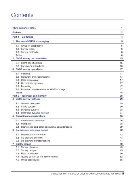
Contents<br />
RICS guidance notes 1<br />
Preface 2<br />
Part 1 – <strong>Guidel<strong>in</strong>es</strong> 4<br />
1 The role <strong>of</strong> <strong>GNSS</strong> <strong>in</strong> survey<strong>in</strong>g 5<br />
1.1 <strong>GNSS</strong> <strong>in</strong> perspective 5<br />
1.2 Survey types 6<br />
1.3 Survey methods 6<br />
Tables 8<br />
2 <strong>GNSS</strong> survey documentation 15<br />
2.1 Client specifications 15<br />
2.2 Surveyor’s procedures 16<br />
3 <strong>GNSS</strong> survey operations 17<br />
3.1 Plann<strong>in</strong>g 17<br />
3.2 Fieldwork <strong>and</strong> observations 17<br />
3.3 Data process<strong>in</strong>g 17<br />
3.4 Co-ord<strong>in</strong>ate systems 17<br />
3.5 Report<strong>in</strong>g 17<br />
3.6 Essential considerations <strong>for</strong> <strong>GNSS</strong> surveys 17<br />
Tables 18<br />
Part 2 – Technical commentary 28<br />
4 <strong>GNSS</strong> survey methods 29<br />
4.1 General pr<strong>in</strong>ciples 29<br />
4.2 Static surveys 30<br />
4.3 Dynamic surveys 33<br />
4.4 Real-time dynamic surveys 34<br />
5 Operational considerations 36<br />
5.1 Atmospheric refraction 36<br />
5.2 Multipath 38<br />
5.3 Interference <strong>and</strong> o<strong>the</strong>r operational considerations 39<br />
6 Co-ord<strong>in</strong>ate reference frames 42<br />
6.1 Description <strong>of</strong> <strong>the</strong> earth 42<br />
6.2 Co-ord<strong>in</strong>ate systems 43<br />
6.3 Co-ord<strong>in</strong>ate trans<strong>for</strong>mations 44<br />
7 Quality issues 49<br />
7.1 Survey plann<strong>in</strong>g 49<br />
7.2 Survey design 49<br />
7.3 Field procedures 50<br />
7.4 Quality control <strong>of</strong> real-time systems 52<br />
7.5 Office procedures 55<br />
GUIDELINES FOR THE USE OF <strong>GNSS</strong> IN LAND SURVEYING AND MAPPING | iii


