

Guidelines for the use of GNSS in surveying and mapping
Guidelines for the use of GNSS in surveying and mapping
Guidelines for the use of GNSS in surveying and mapping

Create successful ePaper yourself
Turn your PDF publications into a flip-book with our unique Google optimized e-Paper software.
steps <strong>use</strong>d <strong>in</strong> generat<strong>in</strong>g <strong>the</strong> local grid coord<strong>in</strong>ates.<br />
This will ensure that any future survey<br />
work is totally compatible with that previously<br />
carried out.<br />
6.3.4 Height trans<strong>for</strong>mations<br />
There is a special treatment required to calculate<br />
<strong>the</strong> heights <strong>of</strong> po<strong>in</strong>ts observed by <strong>GNSS</strong>. It is<br />
simpler to envisage <strong>the</strong> reverse trans<strong>for</strong>mation from<br />
levelled orthometric heights, to those observed by<br />
<strong>GNSS</strong>. Be<strong>for</strong>e any co-ord<strong>in</strong>ate trans<strong>for</strong>mations take<br />
place, <strong>the</strong> elevation height <strong>of</strong> <strong>the</strong> control po<strong>in</strong>t <strong>in</strong><br />
<strong>the</strong> national datum (e.g. to mean sea level (MSL))<br />
must first be converted from an orthometric height<br />
to an ellipsoidal height. Be<strong>for</strong>e any datum<br />
trans<strong>for</strong>mation, this orthometric height is <strong>the</strong> height<br />
<strong>of</strong> <strong>the</strong> control po<strong>in</strong>t above <strong>the</strong> geoid <strong>in</strong> that area,<br />
usually given <strong>the</strong> symbol H.<br />
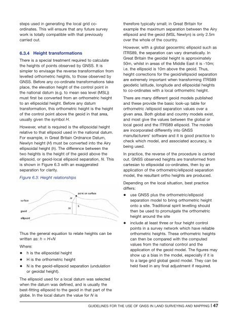
However, what is required is <strong>the</strong> ellipsoidal height<br />
relative to that ellipsoid <strong>use</strong>d <strong>in</strong> <strong>the</strong> national datum.<br />
For example, <strong>in</strong> Great Brita<strong>in</strong> Ordnance Datum,<br />
Newlyn height (H) must be converted <strong>in</strong>to <strong>the</strong> Airy<br />
ellipsoidal height (h). The difference between <strong>the</strong><br />
two heights is <strong>the</strong> height <strong>of</strong> <strong>the</strong> geoid above <strong>the</strong><br />
ellipsoid, or geoid-local ellipsoid separation, N. This<br />
is shown <strong>in</strong> Figure 6.3 with an exaggerated<br />
separation <strong>for</strong> clarity.<br />
Figure 6.3: Height relationships<br />
Thus <strong>the</strong> general equation to relate heights can be<br />
written as: h = H+N<br />
Where:<br />
+ h is <strong>the</strong> ellipsoidal height<br />
+ H is <strong>the</strong> orthometric height<br />
+ N is <strong>the</strong> geoid-ellipsoid separation (undulation<br />
or geoidal height).<br />
The ellipsoid <strong>use</strong>d <strong>for</strong> a local datum was selected<br />
when <strong>the</strong> datum was def<strong>in</strong>ed, <strong>and</strong> is usually <strong>the</strong><br />
best-fitt<strong>in</strong>g ellipsoid to <strong>the</strong> geoid <strong>in</strong> that part <strong>of</strong> <strong>the</strong><br />
globe. In <strong>the</strong> local datum <strong>the</strong> value <strong>for</strong> N is<br />
<strong>the</strong>re<strong>for</strong>e typically small; <strong>in</strong> Great Brita<strong>in</strong> <strong>for</strong><br />
example <strong>the</strong> maximum separation between <strong>the</strong> Airy<br />
ellipsoid <strong>and</strong> <strong>the</strong> geoid (MSL Newlyn) is only 2.5m<br />
over <strong>the</strong> whole <strong>of</strong> <strong>the</strong> country.<br />
However, with a global geocentric ellipsoid such as<br />
ITRS89, <strong>the</strong> separation can vary dramatically. In<br />
Great Brita<strong>in</strong> <strong>the</strong> geoidal height is approximately<br />
50m, whilst <strong>in</strong> areas <strong>of</strong> <strong>the</strong> Middle East it is -10m;<br />
i.e. <strong>the</strong> ellipsoid is 10m above <strong>the</strong> geoid. Thus,<br />
height corrections <strong>for</strong> <strong>the</strong> geoid/ellipsoid separation<br />
are extremely important when trans<strong>for</strong>m<strong>in</strong>g ITRS89<br />
geodetic latitude, longitude <strong>and</strong> ellipsoidal heights<br />
to co-ord<strong>in</strong>ates with a local orthometric height.<br />
There are many different geoid models published<br />
<strong>and</strong> <strong>the</strong>se provide <strong>the</strong> basic look-up table <strong>for</strong><br />
orthometric /ellipsoid separation values over a<br />
given area. Both global <strong>and</strong> country models exist,<br />
<strong>and</strong> most give <strong>the</strong> values between <strong>the</strong> global or<br />
local geoid <strong>and</strong> <strong>the</strong> ITRS89 ellipsoid. The models<br />
are <strong>in</strong>corporated differently <strong>in</strong>to <strong>GNSS</strong><br />
manufacturers’ s<strong>of</strong>tware <strong>and</strong> it is good practice to<br />
check which model, <strong>and</strong> associated accuracy, is<br />
be<strong>in</strong>g <strong>use</strong>d.<br />
In practice, <strong>the</strong> reverse <strong>of</strong> <strong>the</strong> procedure is carried<br />
out. <strong>GNSS</strong> observed heights are trans<strong>for</strong>med from<br />
cartesian to ellipsoidal co-ord<strong>in</strong>ates, <strong>the</strong>n by an<br />
application <strong>of</strong> <strong>the</strong> orthometric/ellipsoid separation<br />
model, <strong>the</strong> resultant ortho heights are produced.<br />
Depend<strong>in</strong>g on <strong>the</strong> local situation, best practice<br />
differs:<br />
+ <strong>use</strong> <strong>GNSS</strong> plus <strong>the</strong> orthometric/ellipsoid<br />
separation model to br<strong>in</strong>g orthometric height<br />
onto a site. Traditional spirit levell<strong>in</strong>g should<br />
<strong>the</strong>n be <strong>use</strong>d to promulgate <strong>the</strong> orthometric<br />
height around <strong>the</strong> site<br />
+ <strong>in</strong>clude at least three or four height control<br />
po<strong>in</strong>ts <strong>in</strong> a survey network which have reliable<br />
orthometric heights. These orthometric heights<br />
can <strong>the</strong>n be compared with <strong>the</strong> computed<br />
values from <strong>the</strong> national control <strong>and</strong> <strong>the</strong><br />
application <strong>of</strong> <strong>the</strong> geoid model. The figures may<br />
show up a bias <strong>in</strong> <strong>the</strong> model, especially if it is<br />
to a large grid global geoid model. They can be<br />
held fixed <strong>in</strong> any f<strong>in</strong>al adjustment if required.<br />
GUIDELINES FOR THE USE OF <strong>GNSS</strong> IN LAND SURVEYING AND MAPPING |47


