

Guidelines for the use of GNSS in surveying and mapping
Guidelines for the use of GNSS in surveying and mapping
Guidelines for the use of GNSS in surveying and mapping

Create successful ePaper yourself
Turn your PDF publications into a flip-book with our unique Google optimized e-Paper software.
6.3.5 Co-ord<strong>in</strong>ate trans<strong>for</strong>mation issues <strong>in</strong><br />
<strong>GNSS</strong><br />
In <strong>GNSS</strong> l<strong>and</strong> surveys, <strong>the</strong>re are several key coord<strong>in</strong>ate<br />
system <strong>and</strong> trans<strong>for</strong>mation issues that<br />
should be considered.<br />
First, <strong>the</strong>re is <strong>the</strong> <strong>use</strong> <strong>of</strong> national control po<strong>in</strong>ts. For<br />
any project a m<strong>in</strong>imum <strong>of</strong> three but preferably four<br />
po<strong>in</strong>ts should be obta<strong>in</strong>ed to control <strong>the</strong> survey<br />
network. An <strong>in</strong>dication <strong>of</strong> <strong>the</strong> actual accuracy <strong>of</strong><br />
<strong>the</strong>se po<strong>in</strong>ts should also be obta<strong>in</strong>ed from <strong>the</strong><br />
national mapp<strong>in</strong>g agency. This needs to be<br />
considered, as older control values from<br />
triangulation surveys will not be as accurate as<br />
<strong>GNSS</strong> values. If <strong>the</strong>se older ‘fundamental coord<strong>in</strong>ates’<br />
are held fixed <strong>in</strong> any network adjustment,<br />
<strong>the</strong> <strong>GNSS</strong> survey geometry will be distorted <strong>and</strong><br />
errors will result <strong>in</strong> <strong>the</strong> survey. There<strong>for</strong>e, good<br />
quality, recently surveyed national control po<strong>in</strong>ts<br />
should be obta<strong>in</strong>ed <strong>for</strong> any survey which requires a<br />
tie to a national grid.<br />
Secondly, if no national grid co-ord<strong>in</strong>ates are<br />
required <strong>and</strong> no national control is <strong>use</strong>d <strong>for</strong> a<br />
survey, it is important to <strong>use</strong> an accurate position <strong>in</strong><br />
ITRS89 as <strong>the</strong> basis <strong>for</strong> <strong>the</strong> survey. If this is not<br />
done, scale errors will result <strong>in</strong> <strong>the</strong> basel<strong>in</strong>es<br />
observed from this base po<strong>in</strong>t. The approximate<br />
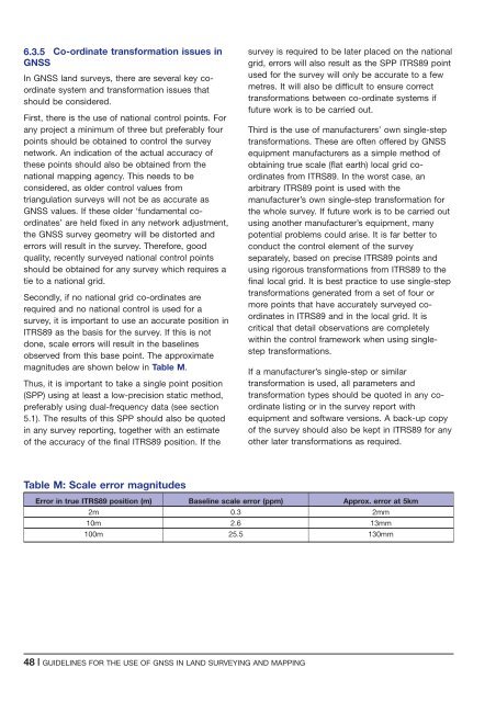
magnitudes are shown below <strong>in</strong> Table M.<br />
Thus, it is important to take a s<strong>in</strong>gle po<strong>in</strong>t position<br />
(SPP) us<strong>in</strong>g at least a low-precision static method,<br />
preferably us<strong>in</strong>g dual-frequency data (see section<br />
5.1). The results <strong>of</strong> this SPP should also be quoted<br />
<strong>in</strong> any survey report<strong>in</strong>g, toge<strong>the</strong>r with an estimate<br />
<strong>of</strong> <strong>the</strong> accuracy <strong>of</strong> <strong>the</strong> f<strong>in</strong>al ITRS89 position. If <strong>the</strong><br />
survey is required to be later placed on <strong>the</strong> national<br />
grid, errors will also result as <strong>the</strong> SPP ITRS89 po<strong>in</strong>t<br />
<strong>use</strong>d <strong>for</strong> <strong>the</strong> survey will only be accurate to a few<br />
metres. It will also be difficult to ensure correct<br />
trans<strong>for</strong>mations between co-ord<strong>in</strong>ate systems if<br />
future work is to be carried out.<br />
Third is <strong>the</strong> <strong>use</strong> <strong>of</strong> manufacturers’ own s<strong>in</strong>gle-step<br />
trans<strong>for</strong>mations. These are <strong>of</strong>ten <strong>of</strong>fered by <strong>GNSS</strong><br />
equipment manufacturers as a simple method <strong>of</strong><br />
obta<strong>in</strong><strong>in</strong>g true scale (flat earth) local grid coord<strong>in</strong>ates<br />
from ITRS89. In <strong>the</strong> worst case, an<br />
arbitrary ITRS89 po<strong>in</strong>t is <strong>use</strong>d with <strong>the</strong><br />
manufacturer’s own s<strong>in</strong>gle-step trans<strong>for</strong>mation <strong>for</strong><br />
<strong>the</strong> whole survey. If future work is to be carried out<br />
us<strong>in</strong>g ano<strong>the</strong>r manufacturer’s equipment, many<br />
potential problems could arise. It is far better to<br />
conduct <strong>the</strong> control element <strong>of</strong> <strong>the</strong> survey<br />
separately, based on precise ITRS89 po<strong>in</strong>ts <strong>and</strong><br />
us<strong>in</strong>g rigorous trans<strong>for</strong>mations from ITRS89 to <strong>the</strong><br />
f<strong>in</strong>al local grid. It is best practice to <strong>use</strong> s<strong>in</strong>gle-step<br />
trans<strong>for</strong>mations generated from a set <strong>of</strong> four or<br />
more po<strong>in</strong>ts that have accurately surveyed coord<strong>in</strong>ates<br />
<strong>in</strong> ITRS89 <strong>and</strong> <strong>in</strong> <strong>the</strong> local grid. It is<br />
critical that detail observations are completely<br />
with<strong>in</strong> <strong>the</strong> control framework when us<strong>in</strong>g s<strong>in</strong>glestep<br />
trans<strong>for</strong>mations.<br />
If a manufacturer’s s<strong>in</strong>gle-step or similar<br />
trans<strong>for</strong>mation is <strong>use</strong>d, all parameters <strong>and</strong><br />
trans<strong>for</strong>mation types should be quoted <strong>in</strong> any coord<strong>in</strong>ate<br />
list<strong>in</strong>g or <strong>in</strong> <strong>the</strong> survey report with<br />
equipment <strong>and</strong> s<strong>of</strong>tware versions. A back-up copy<br />
<strong>of</strong> <strong>the</strong> survey should also be kept <strong>in</strong> ITRS89 <strong>for</strong> any<br />
o<strong>the</strong>r later trans<strong>for</strong>mations as required.<br />
Table M: Scale error magnitudes<br />
Error <strong>in</strong> true ITRS89 position (m) Basel<strong>in</strong>e scale error (ppm) Approx. error at 5km<br />
2m 0.3 2mm<br />
10m 2.6 13mm<br />
100m 25.5 130mm<br />
48 | GUIDELINES FOR THE USE OF <strong>GNSS</strong> IN LAND SURVEYING AND MAPPING


