Th`ese Marouan BOUALI - Sites personnels de TELECOM ParisTech
Th`ese Marouan BOUALI - Sites personnels de TELECOM ParisTech
Th`ese Marouan BOUALI - Sites personnels de TELECOM ParisTech

You also want an ePaper? Increase the reach of your titles
YUMPU automatically turns print PDFs into web optimized ePapers that Google loves.
24 2. Remote Sensing with MODIS<br />
any unit. Radiometric calibration converts instrument digital numbers (DN) to physical<br />
radiance values (W.sr −1 .m −2 ). Since CZCS (Coastal Zone Color Scanner), most space<br />
instruments relie on on-board, in-flight internal calibration systems that inclu<strong>de</strong> a solar<br />
diffuser plate oriented towards the sun. The solar irradiance reaching the diffuser is then<br />
used as a radiance reference to adjust the sensor absolute radiometric calibration. Furthermore,<br />
pre-flight calibrations are not necessarely optimal in the actual space environment<br />
of the sensors and might require further adjustments. On many instruments, the continous<br />
exposure of the diffuser plate to solar radiations and bombardment by space particules,<br />
induces a progressive <strong>de</strong>gradation that needs to be accounted for in the overall system<br />
(see section ). This can be achieved using an additional diffuser to monitor the primary<br />
diffuser <strong>de</strong>gradation (MERIS) or by comparing lunar observations to the light scattered<br />
by the solar diffuser (MODIS and SeaWiFS).<br />
In addition to absolute and relative radiometric calibration, vicarious calibration techniques<br />
are used to minimize errors between satellite-<strong>de</strong>rived data and stable ground targets<br />
with known radiance values. Typical calibration sites inclu<strong>de</strong> <strong>de</strong>sertic regions, ice sheets,<br />
clouds and ocean targets contaminated with sun glint. Assuming the availability of an<br />
extensive in situ data set and a reliable atmospheric correction, the sensor response can<br />
be adjusted so that the values of a geophysical variable estimated from satellite radiances,<br />
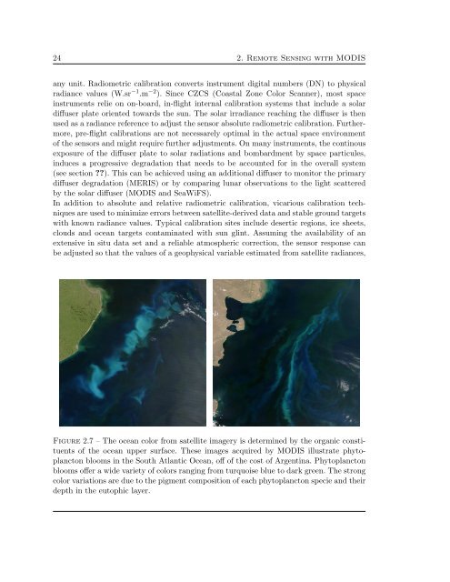
Figure 2.7 – The ocean color from satellite imagery is <strong>de</strong>termined by the organic constituents<br />
of the ocean upper surface. These images acquired by MODIS illustrate phytoplancton<br />
blooms in the South Atlantic Ocean, off of the cost of Argentina. Phytoplancton<br />
blooms offer a wi<strong>de</strong> variety of colors ranging from turquoise blue to dark green. The strong<br />
color variations are due to the pigment composition of each phytoplancton specie and their<br />
<strong>de</strong>pth in the eutophic layer.