Th`ese Marouan BOUALI - Sites personnels de TELECOM ParisTech
Th`ese Marouan BOUALI - Sites personnels de TELECOM ParisTech
Th`ese Marouan BOUALI - Sites personnels de TELECOM ParisTech

Create successful ePaper yourself
Turn your PDF publications into a flip-book with our unique Google optimized e-Paper software.
28 2. Remote Sensing with MODIS<br />
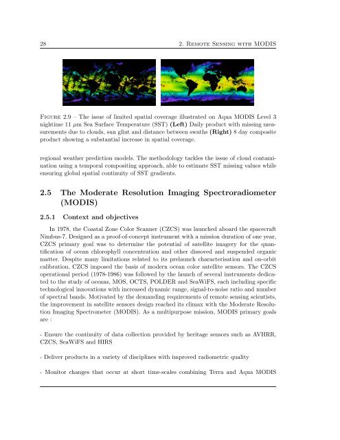
Figure 2.9 – The issue of limited spatial coverage illustrated on Aqua MODIS Level 3<br />
nightime 11 µm Sea Surface Temperature (SST) (Left) Daily product with missing measurements<br />
due to clouds, sun glint and distance between swaths (Right) 8 day composite<br />
product showing a substantial increase in spatial coverage.<br />
regional weather prediction mo<strong>de</strong>ls. The methodology tackles the issue of cloud contamination<br />
using a temporal compositing approach, able to estimate SST missing values while<br />
ensuring global spatial continuity of SST gradients.<br />
2.5 The Mo<strong>de</strong>rate Resolution Imaging Spectroradiometer<br />
(MODIS)<br />
2.5.1 Context and objectives<br />
In 1978, the Coastal Zone Color Scanner (CZCS) was launched aboard the spacecraft<br />
Nimbus-7. Designed as a proof-of-concept instrument with a mission duration of one year,<br />
CZCS primary goal was to <strong>de</strong>termine the potential of satellite imagery for the quantification<br />
of ocean chlorophyll concentration and other dissoved and suspen<strong>de</strong>d organic<br />
matter. Despite many limitations related to its prelaunch characterisation and on-orbit<br />
calibration, CZCS imposed the basis of mo<strong>de</strong>rn ocean color satellite sensors. The CZCS<br />
operational period (1978-1986) was followed by the launch of several instruments <strong>de</strong>dicated<br />
to the study of oceans, MOS, OCTS, POLDER and SeaWiFS, each including specific<br />
technological innovations with increased dynamic range, signal-to-noise ratio and number<br />
of spectral bands. Motivated by the <strong>de</strong>manding requirements of remote sensing scientists,<br />
the improvement in satellite sensors <strong>de</strong>sign reached its climax with the Mo<strong>de</strong>rate Resolution<br />
Imaging Spectrometer (MODIS). As a multipurpose mission, MODIS primary goals<br />
are :<br />
- Ensure the continuity of data collection provi<strong>de</strong>d by heritage sensors such as AVHRR,<br />
CZCS, SeaWiFS and HIRS<br />
- Deliver products in a variety of disciplines with improved radiometric quality<br />
- Monitor changes that occur at short time-scales combining Terra and Aqua MODIS