Th`ese Marouan BOUALI - Sites personnels de TELECOM ParisTech
Th`ese Marouan BOUALI - Sites personnels de TELECOM ParisTech
Th`ese Marouan BOUALI - Sites personnels de TELECOM ParisTech
Create successful ePaper yourself
Turn your PDF publications into a flip-book with our unique Google optimized e-Paper software.
27<br />
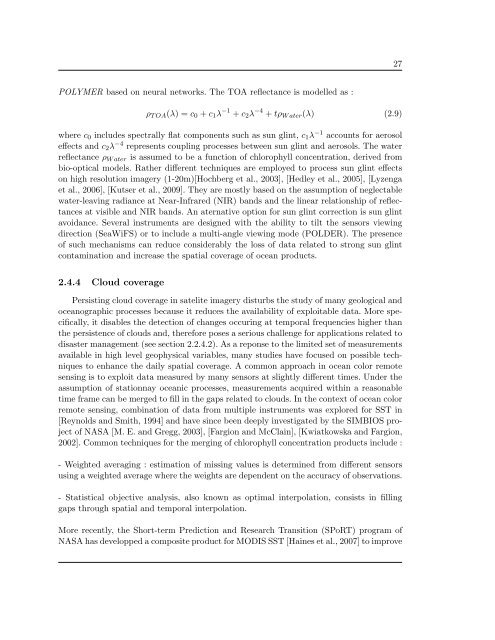
POLYMER based on neural networks. The TOA reflectance is mo<strong>de</strong>lled as :<br />
ρ T OA (λ) =c 0 + c 1 λ −1 + c 2 λ −4 + tρ W ater (λ) (2.9)<br />
where c 0 inclu<strong>de</strong>s spectrally flat components such as sun glint, c 1 λ −1 accounts for aerosol<br />
effects and c 2 λ −4 represents coupling processes between sun glint and aerosols. The water<br />
reflectance ρ W ater is assumed to be a function of chlorophyll concentration, <strong>de</strong>rived from<br />
bio-optical mo<strong>de</strong>ls. Rather different techniques are employed to process sun glint effects<br />
on high resolution imagery (1-20m)[Hochberg et al., 2003], [Hedley et al., 2005], [Lyzenga<br />
et al., 2006], [Kutser et al., 2009]. They are mostly based on the assumption of neglectable<br />
water-leaving radiance at Near-Infrared (NIR) bands and the linear relationship of reflectances<br />
at visible and NIR bands. An aternative option for sun glint correction is sun glint<br />
avoidance. Several instruments are <strong>de</strong>signed with the ability to tilt the sensors viewing<br />
direction (SeaWiFS) or to inclu<strong>de</strong> a multi-angle viewing mo<strong>de</strong> (POLDER). The presence<br />
of such mechanisms can reduce consi<strong>de</strong>rably the loss of data related to strong sun glint<br />
contamination and increase the spatial coverage of ocean products.<br />
2.4.4 Cloud coverage<br />
Persisting cloud coverage in satelite imagery disturbs the study of many geological and<br />
oceanographic processes because it reduces the availability of exploitable data. More specifically,<br />
it disables the <strong>de</strong>tection of changes occuring at temporal frequencies higher than<br />
the persistence of clouds and, therefore poses a serious challenge for applications related to<br />
disaster management (see section 2.2.4.2). As a reponse to the limited set of measurements<br />
available in high level geophysical variables, many studies have focused on possible techniques<br />
to enhance the daily spatial coverage. A common approach in ocean color remote<br />
sensing is to exploit data measured by many sensors at slightly different times. Un<strong>de</strong>r the<br />
assumption of stationnay oceanic processes, measurements acquired within a reasonable<br />
time frame can be merged to fill in the gaps related to clouds. In the context of ocean color<br />
remote sensing, combination of data from multiple instruments was explored for SST in<br />
[Reynolds and Smith, 1994] and have since been <strong>de</strong>eply investigated by the SIMBIOS project<br />
of NASA [M. E. and Gregg, 2003], [Fargion and McClain], [Kwiatkowska and Fargion,<br />
2002]. Common techniques for the merging of chlorophyll concentration products inclu<strong>de</strong> :<br />
- Weighted averaging : estimation of missing values is <strong>de</strong>termined from different sensors<br />
using a weighted average where the weights are <strong>de</strong>pen<strong>de</strong>nt on the accuracy of observations.<br />
- Statistical objective analysis, also known as optimal interpolation, consists in filling<br />
gaps through spatial and temporal interpolation.<br />
More recently, the Short-term Prediction and Research Transition (SPoRT) program of<br />
NASA has <strong>de</strong>velopped a composite product for MODIS SST [Haines et al., 2007] to improve


