City of Playford Report for Munno Para
City of Playford Report for Munno Para
City of Playford Report for Munno Para

Create successful ePaper yourself
Turn your PDF publications into a flip-book with our unique Google optimized e-Paper software.
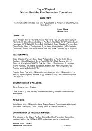
288,250<br />
289,000<br />
289,750<br />
MUNNO PARA DOWNS<br />
Main North Road<br />
Illalong Crescent<br />
1<br />
Alawoona Road<br />
Gurumbi Crescent<br />
2<br />
6,162,000<br />
Woods Court<br />
Ramnet Circuit<br />
MUNNO PARA WEST<br />
Coventry Road<br />
Tyalla Court<br />
Yera Court<br />
Doongara Crescent<br />
Winulta Court<br />
Carcoola Road<br />
Main North Road<br />
6,162,000<br />
Aruma Crescent<br />
Koolena Street<br />
MUNNO PARA<br />
2<br />
Amanda Crescent<br />
Karri Street<br />
Shaun Court<br />
Noora Crescent<br />
1<br />
Medlow Road<br />
Konanda Crescent<br />
4<br />
Wanbi Court<br />
6,161,250<br />
6,161,250<br />
Koongara Crescent<br />
Cutana Crescent<br />
2<br />
BLAKEVIEW<br />
Tallara Crescent<br />
Karinga Crescent<br />
Lulama Crescent<br />
1<br />
Maltarra Road<br />
Palari Crescent<br />
1<br />
1<br />
1<br />
Oration Court<br />
2<br />
Lawder Road<br />
6,160,500<br />
Palina Road<br />
Palina Court<br />
Carrama Crescent<br />
Curtis Road<br />
Mingari Street<br />
Bindui Court<br />
1<br />
Myall Avenue<br />
3<br />
Purdie Road<br />
Scoular Road<br />
6,160,500<br />
7<br />
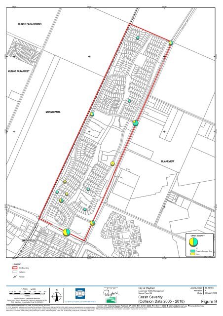
CRASH SEVERITY<br />
SMITHFIELD<br />
Anne Street<br />
Charlotte Street<br />
Jane Street<br />
Moir Street<br />
Queen Street<br />
Gardiner Terrace<br />
Craigmore Road<br />
Craigmore Road<br />
10<br />
Property Damage Only<br />
Injury<br />
Bentley Road<br />
288,250<br />
289,000<br />
289,750<br />
LEGEND<br />
Site Boundary<br />
Cadastre<br />
Railway<br />
o<br />
Job Number<br />
1:7,500 (at A3)<br />
<strong>City</strong> <strong>of</strong> <strong>Play<strong>for</strong>d</strong><br />
0 25 50 100 150 200 250 300 350<br />
Local Area Traffic Management<br />
Revision<br />
<strong>Munno</strong> <strong>Para</strong>, SA<br />
Date<br />
Metres<br />
Map Projection: Transverse Mercator<br />
Crash Severity<br />
Horizontal Datum: Geocentric Datum <strong>of</strong> Australia (GDA)<br />
Grid: Map Grid <strong>of</strong> Australia, Zone 54 (MGA54)<br />
G:\33\15485\Spatial\Maps\MXD\33_15485_03_Crash_Severity_revA.mxd<br />
Level 4, 211 Victoria Square Adelaide SA 5000 T 61 8 8111 6600 F 61 8 8111 6699 E ademail@ghd.com.au W www.ghd.com.au<br />
© 2010. While GHD has taken care to ensure the accuracy <strong>of</strong> this product, GHD and DATA SUPPLIER(S) make no representations or warranties about its accuracy, completeness or suitability <strong>for</strong> any particular purpose. GHD and DATA SUPPLIER(S) cannot accept liability <strong>of</strong> any kind (whether in contract,<br />
tort or otherwise) <strong>for</strong> any expenses, losses, damages and/or costs (including indirect or consequential damage) which are or may be incurred as a result <strong>of</strong> the product being inaccurate, incomplete or unsuitable in any way and <strong>for</strong> any reason.<br />
Data source: Cadastre- PSMA (2010), Road, Railway & Localities - NAVTEQ (2008), Crash data - DTEI (2010), GHD (2010). Created by: J Benedict<br />
33-15485<br />
A<br />
11 MAY 2010<br />
(Collision Data 2005 - 2010) Figure 9