Allegheny River Headwaters Watershed Conservation Plan
Allegheny River Headwaters Watershed Conservation Plan
Allegheny River Headwaters Watershed Conservation Plan

Create successful ePaper yourself
Turn your PDF publications into a flip-book with our unique Google optimized e-Paper software.
<strong>Allegheny</strong> <strong>River</strong> <strong>Headwaters</strong> <strong>Conservation</strong> <strong>Plan</strong><br />
Chapter 5. Cultural Resources<br />
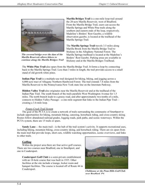
Marilla Bridges Trail is a one-mile loop trail around<br />
the 20-acre Marilla Reservoir, west of Bradford.<br />
From the Marilla Bridge Trail, users can access the<br />
Marilla Springs and White Pine trails along the<br />
southern and eastern ends of the loop, respectively.<br />
Madeline’s Birders’ Rest Gazebo, a wildlife<br />
observation gazebo, is located at the trailhead of the<br />
Marilla Springs Trail.<br />
The covered bridge over the dam of the<br />
Marilla Reservoir allows hikers to<br />
continue along the Marilla Bridges Trail<br />
The Marilla Springs Trail travels 3.5 miles along<br />
Marilla Brook from the Marilla Bridge Trail to<br />
Stickney in the <strong>Allegheny</strong> National Forest. The<br />
Marilla Springs trailhead is located at the Madeline’s<br />
Birders’ Rest Gazebo. Parking areas are available in<br />
Stickney and at the Marilla Bridges Trailhead.<br />
The White Pine Trail also spurs from the Marilla Bridge Trail. It forms a loop by connecting<br />
back to the Marilla Springs Trail. Less than 3 miles in length, the trail provides access to a small<br />
stand of old growth white pines.<br />
Indian Pipe Trail is a multiple-use trail designed for hiking, biking, and jogging across a<br />
4,000-acre tract of Allegany Northern Hardwood Forest. The trail extends 7.4 miles from the<br />
Marilla Reservoir to the Pennsylvania-New York state line on the Interstate Parkway.<br />
Hidden Valley Trail also originates near the Marilla Reservoir and at the trailhead of the<br />
Indian Pipe Trail. The south branch of the trails parallels West Washington Avenue for 1.5<br />
miles. The north branch leads to a grassy road, and after approximately two-tenths of a mile,<br />
connects to Hidden Valley Passage—a one-mile segment that links to the Indian Pipe Trail—<br />
creating a 3.6-mile loop.<br />
Potato Creek Trail System<br />
The goal of the PCTA is to create a network of trails surrounding the community of Smethport to<br />
include opportunities for hiking, mountain biking, canoeing, horseback riding, and cross-country skiing.<br />
Routes follow abandoned railroad grades, logging roads, park paths, and scenic waterways. Within the<br />
PCTA system, there are 15 trails or spurs.<br />
Sandy Lane— the main trail—is the hub of the trail system’s activity. It supports recreational uses,<br />
including hiking, mountain biking, cross-country skiing, and horseback riding. There are six spurs from<br />
the main trail that provide loops, short cuts, wildlife watching opportunities, scenic overviews, and links<br />
to other trails.<br />
Golfing<br />
Within the project area there are four active golf courses.<br />
There are two courses near Bradford, one in Smethport, and<br />
one in Coudersport.<br />
Coudersport Golf Club is a semi-private establishment<br />
with an 18-hole course that was built in 1935. Other<br />
facilities at the site include a lounge, locker room and<br />
banquet facilities. The course is located off of Route 44 in<br />
Coudersport.<br />
Clubhouse at the Penn Hills Golf Club<br />
near Bradford, PA<br />
5-4