Allegheny River Headwaters Watershed Conservation Plan
Allegheny River Headwaters Watershed Conservation Plan
Allegheny River Headwaters Watershed Conservation Plan

You also want an ePaper? Increase the reach of your titles
YUMPU automatically turns print PDFs into web optimized ePapers that Google loves.
<strong>Allegheny</strong> <strong>River</strong> <strong>Headwaters</strong> <strong>Conservation</strong> <strong>Plan</strong><br />
Chapter 3. Water Resources<br />
Riparian Zones<br />
The land area bordering the waterfront of the stream is its riparian zone. These areas, which are often<br />
floodplains, filter pollutants and sediments from runoff and provide an area of transition between water<br />
and land. A highly functional riparian zone acts as a floodplain by reducing flooding and erosion by<br />
decreasing the velocity of the flow, retaining water, and stabilizing the surrounding soil. Riparian zones or<br />
corridors, as they are sometimes called, regulate water temperature, create fish habitat, provide important<br />
corridors for wildlife, and enhance recreational activities.<br />
Vegetative buffers prevent erosion and the undercutting of banks. The roots of plants and trees hold<br />
the soil in place, as opposed to non-vegetative buffers, where the destabilized soil erodes into the<br />
waterway. The above-ground portion of the plants slows down runoff, allowing more water to be<br />
absorbed and recharge groundwater supplies. In addition to ecological benefits, vegetative riparian buffers<br />
can increase property values, decrease property loss due to erosion, and provide privacy and scenic<br />
beauty. Native plants and warm season grasses are most effective, because they tolerate the surrounding<br />
environment and weather conditions, and are naturally resistant to pests and disease.<br />
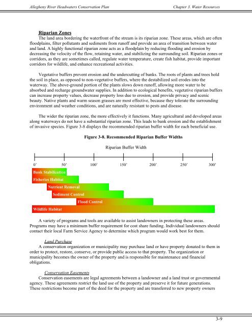
The wider the riparian zone, the more effectively it functions. Many agricultural and developed areas<br />
along waterways do not have a substantial riparian zone. This leads to bank erosion and the establishment<br />
of invasive species. Figure 3-8 displays the recommended riparian buffer width for each beneficial use.<br />
Figure 3-8. Recommended Riparian Buffer Widths<br />
Riparian Buffer Width<br />
0’ 50’ 100’ 150’ 200’ 250’<br />
300’<br />
Bank Stabilization<br />
Fisheries Habitat<br />
Wildlife Habitat<br />
Nutrient Removal<br />
Sediment Control<br />
Flood Control<br />
A variety of programs and tools are available to assist landowners in protecting these areas.<br />
Programs may have a minimum buffer requirement for cost share funding. Individual landowners should<br />
contact their local Farm Service Agency to determine which program would work best for them.<br />
Land Purchase<br />
A conservation organization or municipality may purchase land or have property donated to them in<br />
order to protect, restore, conserve, or provide public access to that property. The organization or<br />
municipality becomes the owner of the property and is responsible for maintenance and financial<br />
obligations.<br />
<strong>Conservation</strong> Easements<br />
<strong>Conservation</strong> easements are legal agreements between a landowner and a land trust or governmental<br />
agency. These agreements restrict the land use of the property and preserve it for future generations.<br />
These restrictions become part of the deed for the property and are transferred to new property owners<br />
3-9