4.8.1 Getting started - WindSim
4.8.1 Getting started - WindSim
4.8.1 Getting started - WindSim
Create successful ePaper yourself
Turn your PDF publications into a flip-book with our unique Google optimized e-Paper software.
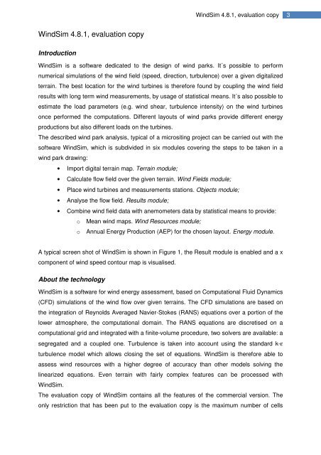
<strong>WindSim</strong> <strong>4.8.1</strong>, evaluation copy3<strong>WindSim</strong> <strong>4.8.1</strong>, evaluation copyIntroduction<strong>WindSim</strong> is a software dedicated to the design of wind parks. It´s possible to performnumerical simulations of the wind field (speed, direction, turbulence) over a given digitalizedterrain. The best location for the wind turbines is therefore found by coupling the wind fieldresults with long term wind measurements, by usage of statistical means. It´s also possible toestimate the load parameters (e.g. wind shear, turbulence intensity) on the wind turbinesonce performed the computations. Different layouts of wind parks provide different energyproductions but also different loads on the turbines.The described wind park analysis, typical of a micrositing project can be carried out with thesoftware <strong>WindSim</strong>, which is subdivided in six modules covering the steps to be taken in awind park drawing:• Import digital terrain map. Terrain module;• Calculate flow field over the given terrain. Wind Fields module;• Place wind turbines and measurements stations. Objects module;• Analyse the flow field. Results module;• Combine wind field data with anemometers data by statistical means to provide:o Mean wind maps. Wind Resources module;o Annual Energy Production (AEP) for the chosen layout. Energy module.A typical screen shot of <strong>WindSim</strong> is shown in Figure 1, the Result module is enabled and a xcomponent of wind speed contour map is visualised.About the technology<strong>WindSim</strong> is a software for wind energy assessment, based on Computational Fluid Dynamics(CFD) simulations of the wind flow over given terrains. The CFD simulations are based onthe integration of Reynolds Averaged Navier-Stokes (RANS) equations over a portion of thelower atmosphere, the computational domain. The RANS equations are discretised on acomputational grid and integrated with a finite-volume procedure, two solvers are available: asegregated and a coupled one. Turbulence is taken into account using the standard k-εturbulence model which allows closing the set of equations. <strong>WindSim</strong> is therefore able toassess wind resources with a higher degree of accuracy than other models solving thelinearized equations. Even terrain with fairly complex features can be processed with<strong>WindSim</strong>.The evaluation copy of <strong>WindSim</strong> contains all the features of the commercial version. Theonly restriction that has been put to the evaluation copy is the maximum number of cells


