

Download full issue - PanamJAS
Download full issue - PanamJAS
Download full issue - PanamJAS
- No tags were found...

Create successful ePaper yourself
Turn your PDF publications into a flip-book with our unique Google optimized e-Paper software.
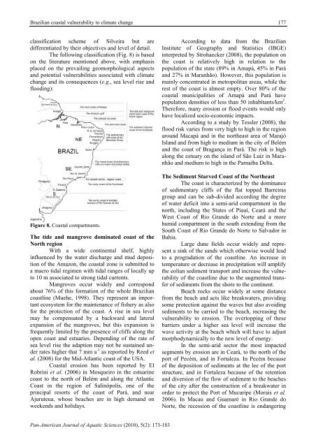
Brazilian coastal vulnerability to climate change177classification scheme of Silveira but aredifferentiated by their objectives and level of detail.The following classification (Fig. 8) is basedon the literature mentioned above, with emphasisplaced on the prevailing geomorphological aspectsand potential vulnerabilities associated with climatechange and its consequences (e.g., sea level rise andflooding):Figure 8. Coastal compartments.The tide and mangrove dominated coast of theNorth regionWith a wide continental shelf, highlyinfluenced by the water discharge and mud depositionof the Amazon, the coastal zone is submitted toa macro tidal regimen with tidal ranges of locally upto 10 m associated to strong tidal currents.Mangroves occur widely and correspondabout 76% of this formation of the whole Braziliancoastline (Muehe, 1998). They represent an importantecosystem for the maintenance of fishery as alsofor the protection of the coast. A rise in sea levelmay be compensated by a backward and lateralexpansion of the mangroves, but this expansion isfrequently limited by the presence of cliffs along theopen coast and estuaries. Depending of the rate ofsea level rise the adaption may not be sustained underrates higher that 7 mm a -1 as reported by Reed etal. (2008) for the Mid-Atlantic coast of the USA.Coastal erosion has been reported by ElRobrini et al. (2006) in Mosqueiro in the estuarinecoast to the north of Belém and along the AtlanticCoast in the region of Salinópolis, one of theprincipal resorts of the coast of Pará, and nearAjuruteua, whose beaches are in high demand onweekends and holidays.According to data from the BrazilianInstitute of Geography and Statistics (IBGE)interpreted by Strohaecker (2008), the population onthe coast is relatively high in relation to thepopulation of the state (89% in Amapá, 45% in Paráand 27% in Maranhão). However, this population ismainly concentrated in metropolitan areas, while therest of the coast is almost empty. Over 80% of thecoastal municipalities of Amapá and Pará havepopulation densities of less than 50 inhabitants/km 2 .Therefore, many erosion or flood events would onlyhave localized socio-economic impacts.According to a study by Tessler (2008), theflood risk varies from very high to high in the regionaround Macapá and in the northeast area of MarajóIsland and from high to medium in the city of Belémand the coast of Bragança in Pará. The risk is highalong the estuary on the island of São Luiz in Maranhãoand medium to high in the Parnaíba Delta.The Sediment Starved Coast of the NortheastThe coast is characterized by the dominanceof sedimentary cliffs of the flat topped Barreirasgroup and can be sub-divided according the degreeof water deficit into a semi-arid compartment in thenorth, including the States of Piauí, Ceará and theWest Coast of Rio Grande do Norte and a morehumid compartment in the south extending from theSouth Coast of Rio Grande do Norte to Salvador inBahia.Large dune fields occur widely and representa sink of the sands which otherwise would leadto a progradation of the coastline. An increase intemperature or decrease in precipitation will amplifythe eolian sediment transport and increase the vulnerabilityof the coastline due to the augmented transferof sediments from the shore to the continent.Beach rocks occur widely at some distancefrom the beach and acts like breakwaters, providingsome protection against the waves but also avoidingsediments to be carried to the beach, increasing thevulnerability to erosion. The overtopping of thesebarriers under a higher sea level will increase thewave activity at the beach which will have to adjustmorphodynamically to the new level of energy.In the semi-arid sector the most impactedsegments by erosion are in Ceará, to the north of theport of Pecém, and in Fortaleza. In Pecém becauseof the deposition of sediments at the lee of the portstructure, and in Fortaleza because of the retentionand diversion of the flow of sediment to the beachesof the city after the construction of a breakwater inorder to protect the Port of Mucuripe (Morais et al.2006). In Macau and Guamaré in Rio Grande doNorte, the recession of the coastline is endangeringPan-American Journal of Aquatic Sciences (2010), 5(2): 173-183


