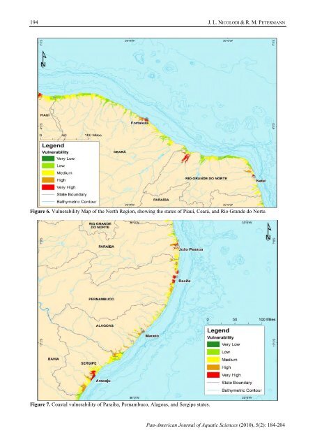
194J. L. NICOLODI & R. M. PETERMANNFigure 6. Vulnerability Map of the North Region, showing the states of Piauí, Ceará, and Rio Grande do Norte.Figure 7. Coastal vulnerability of Paraíba, Pernambuco, Alagoas, and Sergipe states.Pan-American Journal of Aquatic Sciences (2010), 5(2): 184-204
Potential vulnerability of the Brazilian coastal zone195cliffs, and marine abrasion terraces. The sedimentarycoastal plains are little developed, and the plain atthe Doce River mouth is the most relevant.This stretch consists of sections of mediumto low coastal vulnerability. Only three sites wereranked as vulnerable (medium to very high levels):the Doce River, Vitória, and the inner drainage areasof the Paraíba do Sul River (Fig. 10).In the case of the Doce River, one can seethat the combination of the above-mentionedconditions, coupled with high levels of coastalerosion, make the region of São Mateus andConceição da Barra more vulnerable.What adds to this situation is the fact that thestretch of the Coastal Zone between Mucuri, on thesouthern coast of Bahia, to the center-north ofEspírito Santo, especially near Linhares and Aracruzin Espírito Santo, is specializing in the production ofpulp for the foreign market, as can be seen from theconcentration of equipment used by the paper andpulp industry, particularly the continuousdimensions of the area involved (Egler 2008).The Doce River drainage at the end of itsflow at Linhares occurs on low ground showingmarginally to its main flow a number of tributariesconnected to ponds. Attributing higher risk levelsrelates to inundation potential for low land with arate of human occupation slightly above the region’saverage. Vitória, Vila Velha, and Guarapari have thehighest population densities in low coastal areas,with population densities above the Espírito Santostate coast average.The drainage of the Paraíba do Sul River, inthe Campos dos Goytacazes area, occurs at near sealevel land, through densely populated areas boundby the Pre-Cambrian crystalline complex. Thisgeomorphologic setting, associated with the populationdensity of northern Rio de Janeiro state, aretypical of the vectors leading to high vulnerabilitylevels in the area. The town of Atafona, on the southbank of the Paraíba do Sul River mouth, has one ofthe most intense erosive phenomena of the entireSoutheast coast of Brazil (Muehe et al. 2006).The stretch between Cabo Frio andGuanabara Bay has a rim formed by narrow ridgesseparated by rocky headlands, with the developmentof lagoons behind the ridges. This section is alsoknown as the Lake Region. The general direction ofthe coastline, which directly exposes this coastalstretch to the south (with waves from the southquadrant) and, from time to time, to the action ofheavy storms, which explains the strong erosion.The highest levels of vulnerability identifiedon the eastern coast of Rio de Janeiro state are in theareas of São João da Barra and Macaé, which, in thelast two decades, have experienced a sharp urbandevelopment linked to oil prospecting activities onthe contiguous continental shelf (Fig. 11). In CaboFrio, the increase in population in the urban areas, ina land that displays higher landforms (promontoriesand hills) and low-lying coastal plains, lead to anincreased potential hazard to which the area isexposed (Tessler 2008).The Guanabara Bay region is one of themost emblematic cases in Brazil, with regard tovulnerability. Its low topography lies along ageological fault that extends toward the ocean fromthe crystalline complex. To this depression convergeall drainage networks from Serra do Mar mountainrange at the back of the bay, which were blocked attheir low flows by high sea levels during theHolocene.In contrast with the ocean beaches located atits outer edges, constantly exposed to storm cyclesoriginating from south quadrants, the inner baycoastline is affected only occasionally by morepowerful events. Its vicinity, however, concentratesone of the highest population densities in the country9 , sometimes along the lower river streams thatflow into the system. In extreme tidal situations followedby heavy rain on the mountain range (associatedwith the passage of frontal systems whichdrown the drainages in their lower flows) the innerbay coastline, which is lower, is exposed to inundationevents (which increases the volume of rivers).In addition to this context, Rio de Janeirohas the highest ratio in Brazil, between the exposedpopulation (78%) and its total population, equivalentto 11.194,150 people – some 5 million of which inthe capital alone. Data on the social risk of thisportion of the Brazilian territory are alarming, asshown in (Fig. 12).In addition to these factors which lead tohigh vulnerability, the Rio de Janeiro metropolitanarea holds a petrochemical complex, with anintricate network of refineries 10 , natural gas plants 11 ,gas pipelines, and offshore oil fields.The location of a coastal mountain rangenear the existing shoreline, west of Guanabara Bay,with its promontories marking small individual beachesand conspicuous inlets and sedimentary plains9 Rio de Janeiro is the state with the greatest totalpopulation residing in metropolitan areas (75.2%).Additionally, the state includes most coastalmunicipalities with population densities over 1,000inhabitants/km 2 , as is the case of Rio de Janeiro City andNiteroi, the towns of Baixada Fluminense (in the state’slow-lying area) and the outskirts of the metropolitan area.10 Duque de Caxias and Manguinhos Refineries.11 REDUC I and II and Cabiunas I, II, and III.Pan-American Journal of Aquatic Sciences (2010), 5(2): 184-204