- Page 5 and 6:
The Greater Dublin AreaExecutive Su
- Page 7 and 8:
Travel in the Greater Dublin AreaTh
- Page 9 and 10:
Strategy options and assemblingthe
- Page 11 and 12:
The StrategyOverviewThe Strategy ob
- Page 14:
Public TransportPublic transport is
- Page 19 and 20:
Part A:Backgroundand Options
- Page 21:
1.1 Purpose of this documentThe Nat
- Page 24 and 25:
Part B: The Strategy comprises:•
- Page 27:
2.1 IntroductionThis chapter sets o
- Page 31 and 32:
• Mode shift to public transport
- Page 33:
National Spatial Strategy (NSS)The
- Page 36 and 37:
Chapter 3Strategy visionand objecti
- Page 38 and 39:
3.4 Strategy Sub-objectivesThe foll
- Page 40 and 41:
Chapter 4Travel in the GreaterDubli
- Page 42 and 43:
The outer suburbsIn the 1960s, plan
- Page 44 and 45:
4.2 Population growth and settlemen
- Page 46 and 47:
Figure 4.3: Projected distribution
- Page 48:
Figure 4.5: Projected distribution
- Page 51 and 52:
Figure 4.8: Journey purpose and dis
- Page 53 and 54:
4.8 ConclusionsThe projected growth
- Page 56 and 57:
Travel and economic activity are cl
- Page 59 and 60:
Many areas remain poorly served by
- Page 61 and 62:
Figure 5.4: Road fatalities in the
- Page 63 and 64:
Chapter 5: page 9 www.2030vision.ie
- Page 65 and 66:
6.1 IntroductionThis chapter looks
- Page 67 and 68:
While each option attempts to meet
- Page 69 and 70:
Some strategic infrastructure propo
- Page 71 and 72:
Base and forecast yearsThe base yea
- Page 73:
6.11 Assembling the StrategyThe ass
- Page 76 and 77:
Chapter 7Overview of theStrategyIn
- Page 78:
To make this happen, the needs of p
- Page 81 and 82:
8.1 IntroductionTransport is a deri
- Page 83 and 84:
Figure 8.1: RPG Settlement Hierarch
- Page 85 and 86:
8.4 Serving local and strategic tra
- Page 87 and 88:
Measure LU2:Development plans and l
- Page 89 and 90:
Rail based development areas:Outer
- Page 91 and 92:
Measure LU3:Development plans and L
- Page 93 and 94:
Measure LU4:• The Authority will
- Page 95 and 96:
Chapter 8: page 15 www.2030vision.i
- Page 97 and 98:
9.1 IntroductionThe Strategy envisa
- Page 99 and 100:
Footpaths on the approaches to town
- Page 101 and 102:
9.4.2 Improving pedestrian crossing
- Page 103 and 104:
Measure WCY 9:The Authority will:
- Page 105 and 106:
Measure WCY 12:The Authority will s
- Page 107 and 108:
Cycle parking at workplacesThe Depa
- Page 109 and 110:
Chapter 9: page 13 www.2030vision.i
- Page 111 and 112:
10.1 IntroductionPublic transport i
- Page 113 and 114: Measure BUS 2:The Authority will se
- Page 115 and 116: Measure BUS 6:Infrastructural measu
- Page 117 and 118: The hours of operation of bus lanes
- Page 119 and 120: Measure BUS 11:The Authority will s
- Page 121 and 122: An upgrade and renewal of the signa
- Page 123 and 124: Measure RAIL 3 (continued):The Auth
- Page 125 and 126: 10.3.5 Light rail (Metro and Luas)L
- Page 127 and 128: Measure RAIL 10:The Authority will
- Page 129 and 130: Measure RAIL 16:The Authority will
- Page 131 and 132: Taxis can also act as a substitute
- Page 133 and 134: Measure INT 1:The Authority will se
- Page 135 and 136: Measure INT 4:The Authority will se
- Page 138 and 139: Chapter 11Roads, freight andtravel
- Page 140 and 141: The implications of these principle
- Page 142 and 143: The Leinster Orbital Route is an or
- Page 144 and 145: Road authorities need to have polic
- Page 146 and 147: Figure 11.1: Motorways and National
- Page 148 and 149: Managing movements of heavy vehicle
- Page 150 and 151: 11.3 Travel demand management11.3.1
- Page 152 and 153: Measure TDM 1:The Authority will ev
- Page 154 and 155: The Department of Smarter Travel Wo
- Page 156 and 157: Chapter 1: page 18 www.2030vision.i
- Page 158 and 159: Chapter 12Expected OutcomesIn this
- Page 160 and 161: Strategy ObjectivesEconomythemed op
- Page 162 and 163: No. Sub-objective Strategyscore1.2
- Page 166 and 167: 12.3.2 Objective 2 Improve economic
- Page 168 and 169: No. Sub-objective Strategyscore2.2
- Page 170 and 171: No. Sub-objective Strategyscore2.4
- Page 172 and 173: Figure 12.2: Forecast road congesti
- Page 174 and 175: In comparison the equivalent reduct
- Page 176 and 177: No. Sub-objective Strategyscore3.1
- Page 178: 12.3.4 Objective 4 - Respect and su
- Page 181 and 182: Reductions in greenhouse gas emissi
- Page 183 and 184: No. Sub-objective Strategyscore5.2
- Page 185 and 186: No. Sub-objective Strategyscore5.5
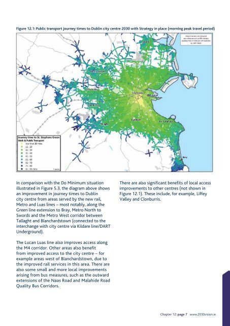
- Page 187 and 188: Total travel time by public transpo
- Page 189 and 190: 12.5 Meeting Smarter Travel targets
- Page 191 and 192: In urban areas, traffic management
- Page 193 and 194: Chapter 12: page 35 www.2030vision.
- Page 195 and 196: 13.1 OverviewChapters 7 to 11 list
- Page 197 and 198: the achievement of, the Strategy an
- Page 199 and 200: Agglomeration: Economic activity co
- Page 201 and 202: Natura 2000: European network of Sp
- Page 204: National Transport AuthorityDún Sc