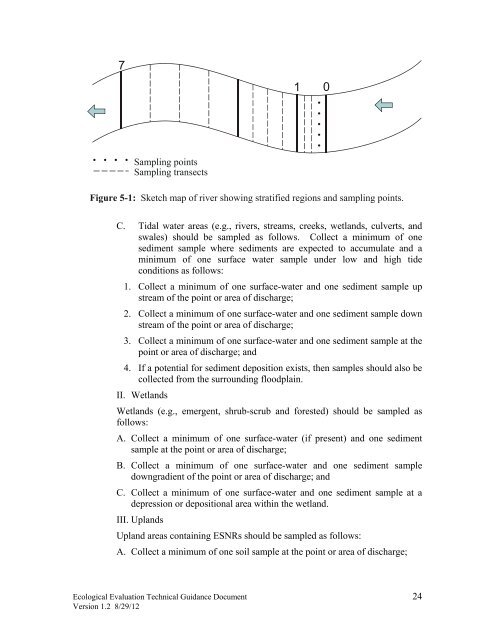
2. Collect a minimum <strong>of</strong> one surface water and sediment sample at eachinflow and outflow area; and3. Collect a minimum <strong>of</strong> one surface water and sediment sample at eachdepositional area where sediments may be expected to accumulate.B. Flowing water areas (e.g., rivers, streams, creeks, wetlands, culverts, andswales) should be sampled as follows: Collect a minimum <strong>of</strong> onesediment sample where sediments are expected to accumulate and aminimum <strong>of</strong> one surface-water sample under low flow (base flow) andhigh flow conditions as follows:1. Collect a minimum <strong>of</strong> one surface-water and one sediment sample upstream <strong>of</strong> the point or area <strong>of</strong> discharge;2. Collect a minimum <strong>of</strong> one surface-water and one sediment sample downstream <strong>of</strong> the point or area <strong>of</strong> discharge; and3. Collect a minimum <strong>of</strong> one surface-water and one sediment sample at thepoint or area <strong>of</strong> discharge.A commonly used approach to locating sediment samples is as follows: Thestream location adjacent to the contaminated site most likely to receivecontaminant input via the contaminant migration pathway is considered theinitial sample point. The study region is divided into linear segments andsample transects are located systematically within each segment; the length<strong>of</strong> the segments and distance between transects increases with increasingdistance downstream. This approach is depicted in Figure 5-1, a diagram <strong>of</strong>a sampling plan indicating 15 sediment samples per segment region. In thisexample, the first segment is from zero to one km, the second from one tothree km, and third from three to seven km. The sampling transects(indicated by dashed lines) are located at 1/4, 1/2, and 3/4 the distance alongeach segment. Sample points (indicated by five dots) are located along thetransects at 1/6, 1/3, 1/2, 2/3, and 5/6 the distance bank to bank (USEPA,1985a). The distance from bank to bank is measured from the mean highwatermark.If a potential for sediment deposition exists, then samples should also becollected from the surrounding floodplain. The actual number and location<strong>of</strong> sample points will be decided on a case-by-case basis, based on the studyobjectives, water-body dimensions, flow conditions, substrate conditions,availability <strong>of</strong> previous data, etc.<strong>Ecological</strong> <strong>Evaluation</strong> <strong>Technical</strong> <strong>Guidance</strong> Document 23Version 1.2 8/29/12
71 0Sampling pointsSampling transectsFigure 5-1: Sketch map <strong>of</strong> river showing stratified regions and sampling points.C. Tidal water areas (e.g., rivers, streams, creeks, wetlands, culverts, andswales) should be sampled as follows. Collect a minimum <strong>of</strong> onesediment sample where sediments are expected to accumulate and aminimum <strong>of</strong> one surface water sample under low and high tideconditions as follows:1. Collect a minimum <strong>of</strong> one surface-water and one sediment sample upstream <strong>of</strong> the point or area <strong>of</strong> discharge;2. Collect a minimum <strong>of</strong> one surface-water and one sediment sample downstream <strong>of</strong> the point or area <strong>of</strong> discharge;3. Collect a minimum <strong>of</strong> one surface-water and one sediment sample at thepoint or area <strong>of</strong> discharge; and4. If a potential for sediment deposition exists, then samples should also becollected from the surrounding floodplain.II. WetlandsWetlands (e.g., emergent, shrub-scrub and forested) should be sampled asfollows:A. Collect a minimum <strong>of</strong> one surface-water (if present) and one sedimentsample at the point or area <strong>of</strong> discharge;B. Collect a minimum <strong>of</strong> one surface-water and one sediment sampledowngradient <strong>of</strong> the point or area <strong>of</strong> discharge; andC. Collect a minimum <strong>of</strong> one surface-water and one sediment sample at adepression or depositional area within the wetland.III. UplandsUpland areas containing ESNRs should be sampled as follows:A. Collect a minimum <strong>of</strong> one soil sample at the point or area <strong>of</strong> discharge;<strong>Ecological</strong> <strong>Evaluation</strong> <strong>Technical</strong> <strong>Guidance</strong> Document 24Version 1.2 8/29/12
- Page 1 and 2: Ecological EvaluationTechnical Guid
- Page 3 and 4: 6.2.1.3 Biological Sampling of Fish
- Page 5 and 6: Acronyms and AbbreviationsADDAETAFA
- Page 7 and 8: Executive SummaryThis document prov
- Page 9 and 10: environmentally sensitive areas pur
- Page 11 and 12: Figure 3-1: Flow diagram to describ
- Page 13 and 14: assessment may also include evaluat
- Page 15 and 16: “Hazard quotient” or “HQ” m
- Page 17 and 18: “Site investigation” means the
- Page 19 and 20: parameters as specified in ERAGS (i
- Page 21 and 22: document otherwise). The investigat
- Page 23: 5.3.2.1 Potential Contaminant Migra
- Page 27 and 28: 5.3.4 Background ConsiderationsIt i
- Page 29 and 30: III. GroundwaterAnalytical data fro
- Page 31 and 32: 5.5 Ecological Evaluation ReportThe
- Page 33 and 34: Step 1 - Preliminary Screening Leve
- Page 35 and 36: specific measurements of receptor h
- Page 37 and 38: Figure 6-2: Ecological Conceptual S
- Page 39 and 40: ingested, air inhaled, or material
- Page 41 and 42: Fugacity, which is described as the
- Page 43 and 44: environment. As noted in ERAGS, the
- Page 45 and 46: Sample SelectionAfter completing th
- Page 47 and 48: While there are many laboratories t
- Page 49 and 50: ioavailability, and by doing so, of
- Page 51 and 52: For the purposes of surface water,
- Page 53 and 54: higher trophic level receptors. Lip
- Page 55 and 56: Details regarding surface water tox
- Page 57 and 58: e present at intervals greater than
- Page 59 and 60: elatively sedentary organisms that
- Page 61 and 62: COPECs. The following references ar
- Page 63 and 64: tests (USEPA, 2002e). After collect
- Page 65 and 66: multiple reference area soils repre
- Page 67 and 68: In ERAs, tissue residue analyses ar
- Page 69 and 70: Objectives of the ERA: including a
- Page 71 and 72: evaluation might necessitate the co
- Page 73 and 74: N.J.A.C. 7:26E-4.8(c)1. The ERA may
- Page 75 and 76:
sediment (i.e., that fraction that
- Page 77 and 78:
Twelve dioxin-like PCB congeners ha
- Page 79 and 80:
indicates burial of potential dioxi
- Page 81 and 82:
of evidence for evaluating risk unt
- Page 83 and 84:
7.2.1 Apparent Effects Threshold Ap
- Page 85 and 86:
when site conditions are most simil
- Page 87 and 88:
destroying 10 acres of the mature f
- Page 89 and 90:
ASTM (American Society for Testing
- Page 91 and 92:
Establishing Sediment Quality Crite
- Page 93 and 94:
N.J.A.C. (New Jersey Administrative
- Page 95 and 96:
USEPA. 1989c. Risk Assessment Guida
- Page 97 and 98:
http://www.epa.gov/owow/oceans/regu
- Page 99 and 100:
USEPA 2006a. Data Quality Assessmen
- Page 101 and 102:
Appendix A - Habitat Survey FormsEc
- Page 103 and 104:
Ecological Evaluation Technical Gui
- Page 105 and 106:
Appendix B - Sampling Procedures fo
- Page 107 and 108:
Appendix C - Surface Water Toxicity
- Page 109 and 110:
Short-term chronic studies, endpoin
- Page 111 and 112:
Appendix D - Sediment Toxicity Test
- Page 113 and 114:
Toxicity Test DesignSediment toxici
- Page 115 and 116:
Appendix E - Sediment Pore Water an
- Page 117 and 118:
The seven-day daphnid survival and
- Page 119 and 120:
esults are then evaluated using USE
- Page 121 and 122:
Surber or Square-foot BottomThis sa
- Page 123 and 124:
Appendix H - Soil Toxicity TestingS
- Page 125 and 126:
another sample may still have a sub
- Page 127 and 128:
conservative approach from an ecolo
- Page 129:
Data PresentationTabular presentati