- Page 3 and 4:
Informe delEstado delAmbienteGEO Ho
- Page 5 and 6:
Colaboradores EspecialesPamela Ordo
- Page 7 and 8:
Finalmente reitero el interés de m
- Page 9:
sectores de ambiente, biodiversidad
- Page 14:
GEO Honduras 2014
- Page 17:
2.5.3 Marco regulatorio del sector
- Page 20 and 21:
20Contexto Físico y DemográficoLa
- Page 23 and 24:
23dichos índices tienen el mismo s
- Page 25 and 26:
25Figura No. 4.- Aspectos demográf
- Page 27 and 28:
27Contexto Económico, Social y Pol
- Page 29 and 30:
29destacando las ventas al exterior
- Page 31:
31generales. Cabe mencionar que los
- Page 34 and 35:
34Producción de Café en Honduras
- Page 36 and 37:
36Figura No. 18.- Exportaciones de
- Page 38 and 39:
38Figura No. 20.- Ingreso de Divisa
- Page 40 and 41:
40Impacto Económico del Sector Tur
- Page 42 and 43:
42Además, han emprendido la búsqu
- Page 44 and 45:
44Por su parte, debido al alza en l
- Page 46 and 47: 46desarrollo humano, la reducción
- Page 48 and 49: 48estructura de recaudación tribut
- Page 50 and 51: 50deficiencias en la infraestructur
- Page 52 and 53: 52Inequidad en la justiciaDe acuerd
- Page 54 and 55: 54Figura No. 32.- Pobreza de los Ho
- Page 56 and 57: 56GEO Honduras 2014
- Page 58 and 59: 58GEO Honduras 2014
- Page 60 and 61: 60Sostenibilidad y Vulnerabilidad A
- Page 62 and 63: 62Principios de DublínPrincipios d
- Page 64 and 65: 64La disponibilidad del recurso agu
- Page 66 and 67: 661617Consejo de Micro-cuencarío L
- Page 68 and 69: 68calidad de agua de las poblacione
- Page 70 and 71: 70La gestión integral de los recur
- Page 72 and 73: 72del sector, y por otra crea las b
- Page 74 and 75: 74La cobertura de acceso a agua en
- Page 76 and 77: 76profesionalización del personal
- Page 78 and 79: 78dejan de operar o las operan de m
- Page 80 and 81: 80(GEI), en los sectores producció
- Page 82 and 83: 82rural, se encuentran amenazadas p
- Page 84 and 85: 84Figura No. 15.- Mapa de Humedales
- Page 86 and 87: 86Figura No. 17.- Mapa Áreas Prote
- Page 88 and 89: 88A continuación se describen las
- Page 90 and 91: 90Caceríaocurre de manera proporci
- Page 92 and 93: 922.2.3 Flora y FaunaHonduras cuent
- Page 94 and 95: 94publicado los registros de un nue
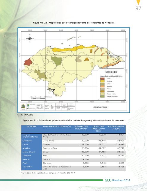
- Page 98 and 99: 98Muchos de estos grupos mantienen
- Page 100 and 101: 100que la costa del Caribe incluye
- Page 102 and 103: 102• Pérdida de actividades recr
- Page 104 and 105: 104b. Contaminación en el Golfo de
- Page 106 and 107: 106urgentes retos, tales como la me
- Page 108 and 109: 108mismas. Su importancia radica en
- Page 110 and 111: 110Figura No. 27.- Estimación de E
- Page 112 and 113: 112Los departamentos con mayor inci
- Page 114 and 115: 114como parte del desarrollo de inv
- Page 116 and 117: 116En conjunto, los costos de la co
- Page 118 and 119: 118El consumo promedio que se deter
- Page 120 and 121: 120Esta reducción de visibilidad g
- Page 122 and 123: 122Figura No. 35.- Porcentaje de Em
- Page 124 and 125: 124Figura No. 39.- Balance Nacional
- Page 126 and 127: 126agroindustrial, tal es el caso d
- Page 128 and 129: 128Figura No. 43.- Ciudades Interme
- Page 130 and 131: 130Figura No. 45.- Proyección de C
- Page 132 and 133: 132la economía de la población y
- Page 134 and 135: 134la porción oeste del Valle de S
- Page 136 and 137: 136Figura No. 47.- Riesgos Identifi
- Page 138 and 139: 138migratoria que sigue concentrand
- Page 140 and 141: 140En términos generales las remes
- Page 142 and 143: 142Característicasde los residuos
- Page 144 and 145: 144ComposiciónSe han realizado est
- Page 146 and 147:
146pasó de 0% a 11.3%, aproximadam
- Page 148 and 149:
148recursos provenientes de agencia
- Page 150 and 151:
150nacional como la agricultura, el
- Page 152 and 153:
152• La falta de voluntad políti
- Page 154 and 155:
154Figura No. 57.- Consumo final de
- Page 156 and 157:
156Figura No. 61.- Emisiones de CO2
- Page 158 and 159:
158Figura No. 64.- Consumo de combu
- Page 160 and 161:
160ha tenido una tasa promedio de c
- Page 162 and 163:
162La leña, es tan importante que
- Page 164 and 165:
164Figura No. 71.- Adición de pote
- Page 166 and 167:
166Eléctrica en Honduras, la cual
- Page 168 and 169:
168Figura No. 72.- Clasificación d
- Page 170 and 171:
170cono el cedro (Cedrela odorata)
- Page 172 and 173:
172producción de agua se determin
- Page 174 and 175:
174crédito. A todo ello se suman l
- Page 176 and 177:
176Principales Cultivos de Honduras
- Page 178 and 179:
178Es uno de los cultivos de mayor
- Page 180 and 181:
180no sustentables de desarrollo ag
- Page 182 and 183:
182más ceremonial, en la colonia l
- Page 184 and 185:
184artesanal en donde resalta princ
- Page 186 and 187:
186de los proyectos, para incentiva
- Page 188 and 189:
188sintéticas, jabones y detergent
- Page 190 and 191:
190Sin embargo, se identifican una
- Page 192 and 193:
192GEO Honduras 2014
- Page 194 and 195:
194LEGISLACIÓNVisión de País, Pl
- Page 196 and 197:
196las instituciones del Estado por
- Page 198 and 199:
198Ley General de MineríaEn 1998 s
- Page 200 and 201:
200armonía con la naturaleza, Obje
- Page 202 and 203:
202mejorar las condiciones de vida
- Page 204 and 205:
204decisión para aprobar la polít
- Page 206 and 207:
206y prioridades del ICF por medio
- Page 208 and 209:
208riesgo, Instalación y operació
- Page 210 and 211:
210de la cohesión local (a nivel d
- Page 212 and 213:
212de manejo, crece por lo menos 55
- Page 214 and 215:
214Honduras: La Tigra.• El primer
- Page 216 and 217:
216Fuente: PROCORREDOR/MIAMBIENTECo
- Page 218 and 219:
218adaptativa de los elementos de c
- Page 220 and 221:
220(PwC) revisó la metodología co
- Page 222 and 223:
222coralinos bajo protección compl
- Page 224 and 225:
2243. Catastro y regulación de la
- Page 226 and 227:
226con la finalidad de incorporar a
- Page 228 and 229:
228en la solidez de algunos grupos
- Page 230 and 231:
230La organización para la impleme
- Page 232 and 233:
232La UTB, también se inserta espe
- Page 234 and 235:
234proyecto en energías renovables
- Page 236 and 237:
236Fortalezas de uso de biocombusti
- Page 238 and 239:
238Figura No. 6.- CaracterísticasP
- Page 240 and 241:
240Con relación a los caudales de
- Page 242 and 243:
242preservación de los recursos h
- Page 244 and 245:
244Consejo Nacional de Agua y Sanea
- Page 246 and 247:
246estandarizando la información g
- Page 248 and 249:
248necesita instalar tanques evapor
- Page 250 and 251:
250agosto. Puede observarse en la i
- Page 252 and 253:
252Objetivos del proyecto:• Desar
- Page 254 and 255:
254de color azul representa el prom
- Page 256 and 257:
256c) Normalizar, en manera gradual
- Page 258 and 259:
258Figura No. 20.- Número de movim
- Page 260 and 261:
260siendo el primer país a nivel i
- Page 262 and 263:
262COPs basados en el principio de
- Page 264 and 265:
264Proyecto Enfrentando riesgos cli
- Page 266 and 267:
266El proyecto fue reestructurado e
- Page 268 and 269:
268Colohete y San Sebastián en el
- Page 270 and 271:
270GEO Honduras 2014
- Page 272 and 273:
272GEO Honduras 2014
- Page 274 and 275:
274ESCENARIOSLos escenarios son rel
- Page 276 and 277:
276Con respecto a servicios básico
- Page 278 and 279:
278existen áreas protegidas sin pl
- Page 280 and 281:
280e implementación de una estrate
- Page 282 and 283:
282GEO Honduras 2014
- Page 284 and 285:
284CONCLUSIONES Y RECOMENDACIONESLa
- Page 286 and 287:
286recuperarse de los daños reales
- Page 288 and 289:
288GEO Honduras 2014
- Page 290 and 291:
290Mapa de las Subcuencas Hidrográ
- Page 292 and 293:
292Mapa de Humedad Media Anual (Añ
- Page 294 and 295:
294Mapa de Temperatura Media AnualG
- Page 296 and 297:
296GEO Honduras 2014
- Page 298 and 299:
298Tabla 1-. Avances del Sector Bio
- Page 300 and 301:
300BIBLIOGRAFIAAFE-COHDEFOR, Secret
- Page 302 and 303:
302Gloria Raquel Rodas Velasquez. (
- Page 304 and 305:
304SERNA,SAG,. (2011). Taller de Se